
Waimangaroa
Encyclopedia
West Coast, New Zealand
The West Coast is one of the administrative regions of New Zealand, located on the west coast of the South Island, and is one of the more remote and most sparsely populated areas of the country. It is made up of three districts: Buller, Grey and Westland...
of New Zealand
New Zealand
New Zealand is an island country in the south-western Pacific Ocean comprising two main landmasses and numerous smaller islands. The country is situated some east of Australia across the Tasman Sea, and roughly south of the Pacific island nations of New Caledonia, Fiji, and Tonga...
.
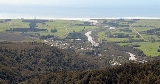
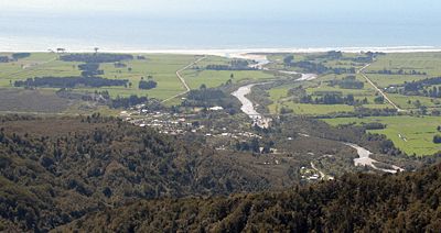
The township lies on the south-west bank of the Waimangaroa River
Waimangaroa River
The Waimangaroa River is located on the West Coast of New Zealand.The river passes through tussock, scrub and forested areas before draining into the Karamea Bight in the Tasman Sea. It passes through the town of Waimangaroa and is crossed by the Ngakawau Branch railway, with the rail bridge...
, at the western foot of the Mt William Range. It is 17 kilometres to the north east of Westport
Westport, New Zealand
-Economy:Economic activity is based around fishing, coal mining and dairy farming. Historically, gold mining was a major industry, and coal mining was much more extensive than today . However, the region still is home to New Zealand's largest opencast mining operation in Stockton...
and 13 km south-east of Granity
Granity
Granity is a small town on the West Coast of New Zealand's South Island, located 28 kilometres north-east of Westport on State Highway 67. Karamea is 68 kilometres further north....
. The abandoned coaltown of Denniston is about 5 km to the south-east. The Bridle Track, a scenic bush track, leads south-east along the Denniston Incline into the foothills of the Mt William Range, to Denniston. The Stockton
Stockton, New Zealand
Stockton is a former settlement in the northwestern South Island of New Zealand in the West Coast region. It is located in the Papahaua Ranges about 30 kilometres linear distance north east from Westport....
mine, a large open cast coal mine
Coal mining
The goal of coal mining is to obtain coal from the ground. Coal is valued for its energy content, and since the 1880s has been widely used to generate electricity. Steel and cement industries use coal as a fuel for extraction of iron from iron ore and for cement production. In the United States,...
, is operated in the vicinity by Solid Energy
Solid Energy
Solid Energy is the largest coal mining company in New Zealand and is a state owned enterprise of the New Zealand Government.The company was formed from the former government department State Coal Mines. It was then established as a state owned enterprise called Coal Corporation in 1987, and...
.
The Ngakawau Branch
Seddonville Branch
The Seddonville Branch, now truncated and operating as the Ngakawau Branch, is a branch line railway in the West Coast region of New Zealand's South Island. Construction of the line began in 1874 and it reached its final terminus at the Mokihinui Mine just beyond Seddonville in 1895...
, a branch line
Branch line
A branch line is a secondary railway line which branches off a more important through route, usually a main line. A very short branch line may be called a spur line...
railway, runs through the town. It opened to Waimangaroa on 5 August 1876; it formerly ran to Seddonville
Seddonville
Seddonville is a lightly populated locality on the West Coast of New Zealand's South Island. It is most famous for the historical role it played in New Zealand's coal mining industry.-Geography:...
but now terminates in Ngakawau. From 1877 until 1967, Waimangaroa was also the junction for the Conns Creek Branch
Conns Creek Branch
The Conns Creek Branch was a short branch line railway in the West Coast region of New Zealand's South Island. It diverged from the Seddonville Branch in Waimangaroa and followed the Waimangaroa River to its terminus at the foot of the Denniston Incline...
, which ran east alongside the Waimangaroa River to the foot of the Denniston Incline. Passenger services ceased on the Conns Creek Branch in 1931 and Ngakawau Branch on 14 October 1946. Since this time, the railway through Waimangaroa has almost solely conveyed coal.
The beaches to the west have dangerous currents and are not safe for swimming.
Education
Waimangaroa School is a coeducational full primary (years 1-8) school with a decile ratingSocio-Economic Decile
Decile, Socio-Economic Decile or Socio-Economic Decile Band is a widely used measure in education in New Zealand used to target funding and support to more needy schools....
of 2 and a roll of 38. The school celebrated its 125th jubilee in 2004.