

Wabash Memorial Bridge
Encyclopedia
The Wabash Memorial Bridge carries vehicular traffic across the Wabash River
between Indiana State Road 62
and Illinois Route 141
. The 4,932 foot long, two-lane bridge is located in both Posey County, Indiana
and White County, Illinois
. The bridge is operated by the Indiana Department of Transportation
(INDOT). The bridge was built in 1956 and has an estimated life of 75 years. It consists of a three tied arch through truss spans, flanked by six plate girder approach spans on each side. It is the southern-most span connecting Illinois and Indiana with the next bridge to the north located in New Harmony, Indiana
. Other than the Indiana Tollroad, it is the last toll bridge with tolls collected in Indiana (there are other toll bridges in Indiana but tolls are collected in ether Illinois or Kentucky). The bridge has an average daily traffic of 4,000 vehicles.
In a $1.67 million resurfacing of the bridge, the contractors used hydrojet demolition instead of jack-hammering to remove a layer of the existing concrete surface. As a result, the project was completed in four months. The bridge remained open to one lane of traffic throughout the construction.
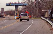 Effective January 1, 2011, INDOT has adopted an electronic toll collection system for the bridge, with users being required to obtain a transponder in order to use the bridge more than once per year. The new automated toll collection system cost $900,000. Tolls are 50 cents for cars, 30 cents for motorcycles or bicycles, and $1.70 for six-axle trucks. The last toll increase was in 1984. Customers pre-pay their tolls on-line or over the telephone using an e-check, debit card or credit card. Each driver will have a windshield decal that contains a transponder circuit associated with the driver's account. Over 7,000 of the ISO 18000 6C sticker tag transponders from Federal Signal/Sirit have been issued.
Wabash River
The Wabash River is a river in the Midwestern United States that flows southwest from northwest Ohio near Fort Recovery across northern Indiana to southern Illinois, where it forms the Illinois-Indiana border before draining into the Ohio River, of which it is the largest northern tributary...
between Indiana State Road 62
Indiana State Road 62
State Road 62 in the U.S. State of Indiana is an east–west route that runs from the Illinois state line in the southwest corner of Indiana to the Louisville, Kentucky area, then northeast toward the Cincinnati, Ohio area.-Route description:...
and Illinois Route 141
Illinois Route 141
Illinois Route 141 is an east–west state road in southeastern Illinois. It runs from U.S. Route 45 west of Omaha to the Wabash Memorial Bridge over the Wabash River into Indiana. The bridge is also the western terminus of State Road 62...
. The 4,932 foot long, two-lane bridge is located in both Posey County, Indiana
Posey County, Indiana
As of the census of 2000, there were 27,061 people, 10,205 households, and 7,612 families residing in the county. The population density was 66 people per square mile . There were 11,076 housing units at an average density of 27 per square mile...
and White County, Illinois
White County, Illinois
White County is a county located in the U.S. state of Illinois. According to the 2010 census, it has a population of 14,665, which is a decrease of 4.6% from 15,371 in 2000...
. The bridge is operated by the Indiana Department of Transportation
Indiana Department of Transportation
The Indiana Department of Transportation is a governmental agency of the U.S. state of Indiana charged with maintaining and regulating transportation and transportation related infrastructure such as state owned airports, state highways and state owned canals or railroads.-Districts:INDOT is...
(INDOT). The bridge was built in 1956 and has an estimated life of 75 years. It consists of a three tied arch through truss spans, flanked by six plate girder approach spans on each side. It is the southern-most span connecting Illinois and Indiana with the next bridge to the north located in New Harmony, Indiana
New Harmony, Indiana
New Harmony is a historic town on the Wabash River in Harmony Township, Posey County, Indiana, United States. It lies north of Mount Vernon, the county seat. The population was 916 at the 2000 census. It is part of the Evansville metropolitan area. Many of the old Harmonist buildings still stand...
. Other than the Indiana Tollroad, it is the last toll bridge with tolls collected in Indiana (there are other toll bridges in Indiana but tolls are collected in ether Illinois or Kentucky). The bridge has an average daily traffic of 4,000 vehicles.
In a $1.67 million resurfacing of the bridge, the contractors used hydrojet demolition instead of jack-hammering to remove a layer of the existing concrete surface. As a result, the project was completed in four months. The bridge remained open to one lane of traffic throughout the construction.