
VZ Navigator
Encyclopedia
VZ Navigator is a GPS navigation software
for Verizon Wireless
phones that turns the phone into a GPS navigation device
. It is a white label product
based on Networks in Motion's AtlasBook mobile navigation platform. It is compatible with many recent Verizon GPS Phones, and available through Get It Now. It uses both GPS and cellular antennas through Assisted GPS
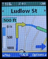
. It supports turn-by-turn navigation
, local area searches to search for businesses, ATMs, gas stations, etc., favorites, messaging between VZ Navigator users (in order to share addresses and/or times of arrival), maps (including "Where Am I?") and multiple voices. It uses the user's phone connection to download maps and to do searches. Once the map and route are downloaded, the phone can manage its position along the path without reconnecting. This initial update usually takes about 5 to 10 seconds. However, if the user departs from his planned route, the mobile phone will automatically contact the server for a new one.
The mobile phone is insensitive to which way the unit is pointing, guessing by which way the user is moving. If directions are requested while standing still (or moving very slowly) the phone might start off with an inadequate order. If the user takes a path not suggested, the phone will recalculate the route up to three times before requesting a completely new route or quitting the current one. It also has pedestrian support (ignoring one way streets, for example), avoiding HOV lanes or toll roads. The user can specify if the route calculated is the simplest, shortest, or fastest.
GPS position is updated every 1 to 2 seconds on average, and it is possible to obtain the user's land speed and altitude from within the software.
It is possible to find out the user's location in coordinates instead of the physical address (provided it is in the database.) This requires going into the service menu and enabling gpsOne
calls and dialing a special number, then checking the phone's GPS logs. This has so far only been verified in LG phones.
In versions 6.1 and above, you can access your location from the menu > location info option. It will also display your speed, altitude, and heading.
The service includes a feature where two wireless devices that have the software installed can TXT message themselves addresses and their ETA
, while the receiving unit can integrate the address into the database and utilize it for navigation.
VZ Navigator can sync with an online map browser at . Favorites and Recent Searches can be shared between the web interface and the wireless device, making it possible to back up the address and phone book in case of phone changeout or damage. Also, this makes it easier to plan a trip since users can enter the address or search for a destination online and then send the destination to any Verizon Wireless device for quick directions.
The cost is $2.99 per day, $4.99 per week or $9.99 per month. VZ Navigator will not use airtime, on America's Choice plans, or incur data transfer charges, on Nationwide plans, to download updates to the software, maps updates, routes or re-routes.
Version 4.5.1 of the software adds voice recognition abilities to most menu screens. Simply hold the "Send" key while you speak the name and release when finished. The device will analyze the voice imprint and automatically convert to text. Menu transitions have been added to the GUI for a smoother look. Note: As of this writing, the upgrade must be done from the VZ menu "Upgrade Check" rather than from within VZ Navigator. Checking for updates from within the program show none available. 4.5.1 is a very worthwhile upgrade and further adds to the functionality of the software.
Version 5.1 updated the application User Interface (UI) and routing.
Version 6.1 again updated the application UI and search engine. The formerly proprietary engine (assumed to be Networks In Motion), was replaced by Bing(TM) local search.
Version X updated the application UI and added new traffic avoidance routing technology, day/night mode, and new mapping tools, including satellite view and City views for 6 major cities (Los Angeles, Chicago, Kansas City, Detroit, New York City, Washington DC).
Most new devices that can install and run third-party app such as Google Maps now have access to the device's GPS chip.
The ability to see LAT/LON Coordinates depends on the Version of VZ Navigator. In earlier versions of VZ Navigator (i.e. Before 5.0) GPS coordinates were available for ALL locations. This functionality was again restored in version 6.1 and higher.
Some customers complain that the VZ Navigator does not avoid toll roads, like the "Avoid Toll Roads" feature suggests it should.
Some customers have complained about the version 5.1.0 being buggy, slow or lacking formerly available features. An option to downgrade was given to customers, and was available through July 30, 2010. Newer versions have removed these concerns.
GPS navigation software
GPS navigation software usually falls into one of the following two categories:# Navigation with route calculation and directions from the software to the user of the route to take, based on a vector-based map, normally for motorised vehicles with some motorised forms added on as an afterthought.#...
for Verizon Wireless
Verizon Wireless
Cellco Partnership, doing business as Verizon Wireless, is one of the largest mobile network operators in the United States. The network has 107.7 million subscribers as of 2011, making it the largest wireless service provider in America....
phones that turns the phone into a GPS navigation device
GPS navigation device
A GPS navigation device is any device that receives Global Positioning System signals for the purpose of determining the device's current location on Earth...
. It is a white label product
White label product
A white label product or service is a product or service produced by one company that other companies rebrand to make it appear as if they made it.-History:...
based on Networks in Motion's AtlasBook mobile navigation platform. It is compatible with many recent Verizon GPS Phones, and available through Get It Now. It uses both GPS and cellular antennas through Assisted GPS
Assisted GPS
Assisted GPS, generally abbreviated as A-GPS or aGPS, is a system which can, under certain conditions, improve the startup performance, or time-to-first-fix of a GPS satellite-based positioning system. It is used extensively with GPS-capable cellular phones as its development was accelerated by...
. It supports turn-by-turn navigation
Turn-by-turn navigation
Turn-by-turn navigation is a feature of some GPS navigation devices where directions for a selected route are continually presented to the user in the form of spoken and visual instructions. The system keeps the user up-to-date about the best route to the destination, and is often updated according...
, local area searches to search for businesses, ATMs, gas stations, etc., favorites, messaging between VZ Navigator users (in order to share addresses and/or times of arrival), maps (including "Where Am I?") and multiple voices. It uses the user's phone connection to download maps and to do searches. Once the map and route are downloaded, the phone can manage its position along the path without reconnecting. This initial update usually takes about 5 to 10 seconds. However, if the user departs from his planned route, the mobile phone will automatically contact the server for a new one.
The mobile phone is insensitive to which way the unit is pointing, guessing by which way the user is moving. If directions are requested while standing still (or moving very slowly) the phone might start off with an inadequate order. If the user takes a path not suggested, the phone will recalculate the route up to three times before requesting a completely new route or quitting the current one. It also has pedestrian support (ignoring one way streets, for example), avoiding HOV lanes or toll roads. The user can specify if the route calculated is the simplest, shortest, or fastest.
GPS position is updated every 1 to 2 seconds on average, and it is possible to obtain the user's land speed and altitude from within the software.
It is possible to find out the user's location in coordinates instead of the physical address (provided it is in the database.) This requires going into the service menu and enabling gpsOne
GpsOne
gpsOne is the brand name for a cellphone chipset manufactured by Qualcomm that allows cell phones to more accurately plot a user's position, using a technology referred to as A-GPS or Assisted-GPS...
calls and dialing a special number, then checking the phone's GPS logs. This has so far only been verified in LG phones.
In versions 6.1 and above, you can access your location from the menu > location info option. It will also display your speed, altitude, and heading.
The service includes a feature where two wireless devices that have the software installed can TXT message themselves addresses and their ETA
Estimated time of arrival
The estimated time of arrival or ETA is a measure of when a ship, vehicle, aircraft, cargo, emergency service or computer file is expected to arrive at a certain place...
, while the receiving unit can integrate the address into the database and utilize it for navigation.
VZ Navigator can sync with an online map browser at . Favorites and Recent Searches can be shared between the web interface and the wireless device, making it possible to back up the address and phone book in case of phone changeout or damage. Also, this makes it easier to plan a trip since users can enter the address or search for a destination online and then send the destination to any Verizon Wireless device for quick directions.
The cost is $2.99 per day, $4.99 per week or $9.99 per month. VZ Navigator will not use airtime, on America's Choice plans, or incur data transfer charges, on Nationwide plans, to download updates to the software, maps updates, routes or re-routes.
Versions
On May 8, 2008, Verizon released version 4 of the VZ Navigator software to include Traffic Avoidance (in certain areas) and other features such as Local Movies and Events, 3D Perspective View, Gas Finder and Weather.Version 4.5.1 of the software adds voice recognition abilities to most menu screens. Simply hold the "Send" key while you speak the name and release when finished. The device will analyze the voice imprint and automatically convert to text. Menu transitions have been added to the GUI for a smoother look. Note: As of this writing, the upgrade must be done from the VZ menu "Upgrade Check" rather than from within VZ Navigator. Checking for updates from within the program show none available. 4.5.1 is a very worthwhile upgrade and further adds to the functionality of the software.
Version 5.1 updated the application User Interface (UI) and routing.
Version 6.1 again updated the application UI and search engine. The formerly proprietary engine (assumed to be Networks In Motion), was replaced by Bing(TM) local search.
Version X updated the application UI and added new traffic avoidance routing technology, day/night mode, and new mapping tools, including satellite view and City views for 6 major cities (Los Angeles, Chicago, Kansas City, Detroit, New York City, Washington DC).
Complaints and Criticisms
Many customers complain about the price of VZ Navigator.Most new devices that can install and run third-party app such as Google Maps now have access to the device's GPS chip.
The ability to see LAT/LON Coordinates depends on the Version of VZ Navigator. In earlier versions of VZ Navigator (i.e. Before 5.0) GPS coordinates were available for ALL locations. This functionality was again restored in version 6.1 and higher.
Some customers complain that the VZ Navigator does not avoid toll roads, like the "Avoid Toll Roads" feature suggests it should.
Some customers have complained about the version 5.1.0 being buggy, slow or lacking formerly available features. An option to downgrade was given to customers, and was available through July 30, 2010. Newer versions have removed these concerns.