
Utah State Route 210
Encyclopedia
State Route 210 is a state route in the U.S. state
of Utah
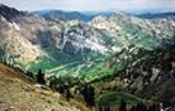
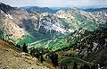
that is the access road for Little Cottonwood Canyon
and the ski resorts of Alta and Snowbird
. The 13.62 mi (21.92 km) highway straddles the southeastern edge of the Salt Lake Valley
before it enters the mouth of Little Cottonwood Canyon.
.
 The state legislature defined State Route 210 in 1941 to run from SR-4 (US-40, now I-80) at the mouth of Parley's Canyon
south along Wasatch Boulevard to Little Cottonwood Canyon
, then east through the canyon to Alta. In 1945, the west end was moved to the intersection of Fort Union Boulevard (then SR-152) and Highland Drive. The route now followed Highland Drive and Bengal Boulevard, rejoining the former alignment at 3500 East (then part of Wasatch Boulevard). A short piece of Wasatch Boulevard north of 3300 South remained a state highway, as an extension of SR-171, but the remainder was removed from the system.
State Route 229 was also defined in 1941, connecting SR-210 near Alta to SR-152 (now SR-190) near Brighton along a proposed roadway. The definition of SR-210 was changed in 1969 to absorb this mountainous route, but in 1994 it was truncated back to Alta, the extension having not been constructed. Also in 1969, the west end was changed again, beginning at SR-152 near the mouth of Big Cottonwood Canyon
and following Wasatch Boulevard to the Little Cottonwood Canyon turnoff. The Alta Bypass Road was added to SR-210 in 1975, providing an alternate route when snow slides close the main roadway. A final extension on the west end was made in 1987, continuing north on Wasatch Boulevard and northwest on a then-proposed limited access extension of 6200 South to I-215. However, a year later, this instead became part of the recently-formed SR-190 so that SR-210 would not have to be remileposted.
!County
!Location
!Mile
!Junction
!Notes
|-
U.S. state
A U.S. state is any one of the 50 federated states of the United States of America that share sovereignty with the federal government. Because of this shared sovereignty, an American is a citizen both of the federal entity and of his or her state of domicile. Four states use the official title of...
of Utah
Utah
Utah is a state in the Western United States. It was the 45th state to join the Union, on January 4, 1896. Approximately 80% of Utah's 2,763,885 people live along the Wasatch Front, centering on Salt Lake City. This leaves vast expanses of the state nearly uninhabited, making the population the...
that is the access road for Little Cottonwood Canyon
Little Cottonwood Canyon
Little Cottonwood Canyon lies within the Wasatch-Cache National Forest along the eastern side of the Salt Lake Valley, roughly 15 miles from Salt Lake City, Utah. The canyon is part of Granite, a CDP and “Community Council” designated by Salt Lake County. The canyon is a glacial trough , carved by...
and the ski resorts of Alta and Snowbird
Snowbird, Utah
Snowbird is an unincorporated area based in Little Cottonwood Canyon in the Wasatch Range of the Rocky Mountains in Salt Lake County, Utah, U.S. It is most famous for Snowbird Ski and Summer Resort, an alpine skiing and snowboarding area, which opened in December 1971.- History :Snowbird is a...
. The 13.62 mi (21.92 km) highway straddles the southeastern edge of the Salt Lake Valley
Salt Lake Valley
Salt Lake Valley is a valley in Salt Lake County in the north-central portion of the U.S. state of Utah. It contains Salt Lake City and many of its suburbs, notably West Valley City, Murray, Sandy, and West Jordan; its total population is 1,029,655 as of 2010...
before it enters the mouth of Little Cottonwood Canyon.
Route description
The highway heads south on Wasatch Boulevard from the point SR-190 turns east from that road onto Fort Union Boulevard. The four-lane undivided highway continues south-southwest before turning south-southeast again past the intersection of 3500 East. The route then turns off of Wasatch Boulevard and onto Little Cottonwood Canyon Road past the junction of Danish Road and turns east-southeast approaching SR-209. The route turns east entering the mouth of Little Cottonwood Canyon and continues east and east-northeast before terminating in AltaAlta, Utah
Alta is a town in Salt Lake County, Utah, United States. It is part of the Salt Lake City, Utah Metropolitan Statistical Area. The population was 370 at the 2000 census, a slight decrease from the 1990 figure of 397....
.
History
Parley's Canyon
Parley's Canyon is a canyon located in the U.S. state of Utah. The canyon provides the route of Interstate 80 up the western slope of the Wasatch Mountains and is a relatively wide, straight canyon. The lower part of the canyon, however, is relatively twisty and had to be dynamited to make way for...
south along Wasatch Boulevard to Little Cottonwood Canyon
Little Cottonwood Canyon
Little Cottonwood Canyon lies within the Wasatch-Cache National Forest along the eastern side of the Salt Lake Valley, roughly 15 miles from Salt Lake City, Utah. The canyon is part of Granite, a CDP and “Community Council” designated by Salt Lake County. The canyon is a glacial trough , carved by...
, then east through the canyon to Alta. In 1945, the west end was moved to the intersection of Fort Union Boulevard (then SR-152) and Highland Drive. The route now followed Highland Drive and Bengal Boulevard, rejoining the former alignment at 3500 East (then part of Wasatch Boulevard). A short piece of Wasatch Boulevard north of 3300 South remained a state highway, as an extension of SR-171, but the remainder was removed from the system.
State Route 229 was also defined in 1941, connecting SR-210 near Alta to SR-152 (now SR-190) near Brighton along a proposed roadway. The definition of SR-210 was changed in 1969 to absorb this mountainous route, but in 1994 it was truncated back to Alta, the extension having not been constructed. Also in 1969, the west end was changed again, beginning at SR-152 near the mouth of Big Cottonwood Canyon
Big Cottonwood Canyon
Big Cottonwood Canyon is a canyon in the Wasatch Range southeast of Salt Lake City in the U.S. state of Utah. The -long canyon provides hiking, biking, picnicking, rock-climbing, camping and fishing in the summer. During winter, its two ski resorts, Brighton and Solitude, are popular among skiers...
and following Wasatch Boulevard to the Little Cottonwood Canyon turnoff. The Alta Bypass Road was added to SR-210 in 1975, providing an alternate route when snow slides close the main roadway. A final extension on the west end was made in 1987, continuing north on Wasatch Boulevard and northwest on a then-proposed limited access extension of 6200 South to I-215. However, a year later, this instead became part of the recently-formed SR-190 so that SR-210 would not have to be remileposted.
Major intersections
{|class=wikitable!County
!Location
!Mile
!Junction
!Notes
|-