

U.S. Route 266
Encyclopedia
U.S. Highway 266 is an east–west United States highway. It is only 43 miles (69 km) long, and lies entirely within the state of Oklahoma
. The highway does not meet the former route of its parent, U.S. Highway 66, and is closely paralleled by Interstate 40, which replaced US-266 (along with accompanying routes US-62 from Oklahoma City to Henryetta and US-64 from Warner to the Arkansas border west of Fort Smith, Arkansas
) as the major east–west highway east of Oklahoma City during the 1960s.
The highway's eastern terminus is in Warner, Oklahoma
at an intersection with U.S. Highway 64, concurrent with State Highway 2
. Its western terminus is in Henryetta, Oklahoma
at an intersection with U.S. Highway 75 and U.S. Highway 62.
 US-266 begins at US-62/US-75 on the northeast side of Henryetta, approximately 2 miles (3.2 km) north of Interstate 40. The highway heads east from this point, quickly crossing into the town of Dewar
, which it bisects. As it leaves Dewar, US-266 turns northeast, crossing Coal Creek and the Deep Fork River
. The highway bypasses Hoffman
to the east, providing access via Hoffman Road. The route then passes through the southeastern outskirts of Grayson
. The highway then turns due east. Immediately after the curve, the highway serves as the southern terminus of SH-52's northern section. US-266 then continues east into McIntosh County
.
US-266 continues due east, running parallel to the Deep Fork Arm of Eufaula Lake
, the reservoir's northernmost arm. South of Council Hill
, the highway intersects SH-72 at its southern terminus. US-266 turns south-southeast, continuing the alignment of SH-72. The route then turns back to the east and heads into the city of Checotah
. On the west side of town, US-266 has an interchange with the modern freeway route of US-69. Further east, in downtown Checotah, the route intersects the old alignment of US-69, US-69 Business. The highway heads due east out of Checotah, descending a ridge and passing just south of its summit, Mt. Nebo. The highway passes under Interstate 40 just before crossing into Muskogee County.
Just under 3 miles (4.8 km) east of the McIntosh–Muskogee county line, US-266 intersects the southern SH-2. US-266 begins a concurrency
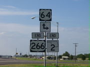
with the state route, traveling northwest to an interchange with I-40, numbered as Exit 278. The highways then curve around to due north to pass through Warner
. On the north edge of Warner lies an intersection with US-64, where both US-266 and SH-2 end. Continuing straight puts the traveler on westbound US-64 bound for Tulsa, while turning right brings the motorist onto eastbound US-64 toward Fort Smith, Arkansas
.
. Upon the US route system's inception, US-266 replaced SH-9 from US-66 in Oklahoma City to US-64 in Warner. By 1930, along with changes to several other branches of US-66 http://www.fhwa.dot.gov/infrastructure/us666.htm, the route was truncated at Henryetta. The segment from Oklahoma City to Henryetta became part of U.S. Highway 62, which was commissioned in 1930.
Oklahoma
Oklahoma is a state located in the South Central region of the United States of America. With an estimated 3,751,351 residents as of the 2010 census and a land area of 68,667 square miles , Oklahoma is the 28th most populous and 20th-largest state...
. The highway does not meet the former route of its parent, U.S. Highway 66, and is closely paralleled by Interstate 40, which replaced US-266 (along with accompanying routes US-62 from Oklahoma City to Henryetta and US-64 from Warner to the Arkansas border west of Fort Smith, Arkansas
Fort Smith, Arkansas
Fort Smith is the second-largest city in Arkansas and one of the two county seats of Sebastian County. With a population of 86,209 in 2010, it is the principal city of the Fort Smith, Arkansas-Oklahoma Metropolitan Statistical Area, a region of 298,592 residents which encompasses the Arkansas...
) as the major east–west highway east of Oklahoma City during the 1960s.
The highway's eastern terminus is in Warner, Oklahoma
Warner, Oklahoma
Warner is a town in Muskogee County, Oklahoma, United States. The population was 1,430 at the 2000 census. The town is also home to part of the Connors State College campus.-Geography:Warner is located at ....
at an intersection with U.S. Highway 64, concurrent with State Highway 2
State Highway 2 (Oklahoma)
State Highway 2, abbreviated SH-2 or OK-2, is a designation for two distinct highways maintained by the U.S. state of Oklahoma. Though they were once connected, the middle section of highway was concurrent with three different U.S. highways, so the middle section was decommissioned for reasons of...
. Its western terminus is in Henryetta, Oklahoma
Henryetta, Oklahoma
Henryetta is a city in Okmulgee County, Oklahoma, United States. The population was 6,096 at the 2000 census.Henryetta is notable as the high school hometown of NFL Hall of Fame quarterback Troy Aikman...
at an intersection with U.S. Highway 75 and U.S. Highway 62.
Route description
Dewar, Oklahoma
Dewar is a town in Okmulgee County, Oklahoma, United States. The population was 919 at the 2000 census.-Geography:Dewar is located at ....
, which it bisects. As it leaves Dewar, US-266 turns northeast, crossing Coal Creek and the Deep Fork River
Deep Fork River
Deep Fork River is an Oklahoma tributary of the North Canadian River. The headwaters flow from north Oklahoma City and the river empties into the North Canadian at Lake Eufaula about away....
. The highway bypasses Hoffman
Hoffman, Oklahoma
Hoffman is a town in Okmulgee County, Oklahoma, United States. The population was 148 at the 2000 census.-Geography:Hoffman is located at .According to the United States Census Bureau, the town has a total area of , all of it land....
to the east, providing access via Hoffman Road. The route then passes through the southeastern outskirts of Grayson
Grayson, Oklahoma
Grayson is a town in Okmulgee County, Oklahoma, United States. The population was 134 at the 2000 census.-Geography:Grayson is located at .According to the United States Census Bureau, the town has a total area of , all of it land....
. The highway then turns due east. Immediately after the curve, the highway serves as the southern terminus of SH-52's northern section. US-266 then continues east into McIntosh County
McIntosh County, Oklahoma
McIntosh County is a county located in the U.S. state of Oklahoma. As of 2000, the population was 19,456. Its county seat is Eufaula.-Geography:...
.
US-266 continues due east, running parallel to the Deep Fork Arm of Eufaula Lake
Eufaula Lake
Eufaula Lake is a reservoir in Oklahoma. It is located on the Canadian River, upstream from its confluence with the Arkansas River and near the town of Eufaula. It is the largest lake in the state of Oklahoma with and of shoreline....
, the reservoir's northernmost arm. South of Council Hill
Council Hill, Oklahoma
Council Hill is a town in Muskogee County, Oklahoma, United States. The population was 129 at the 2000 census.-Geography:Council Hill is located at ....
, the highway intersects SH-72 at its southern terminus. US-266 turns south-southeast, continuing the alignment of SH-72. The route then turns back to the east and heads into the city of Checotah
Checotah, Oklahoma
Checotah is a city in McIntosh County, Oklahoma, United States. It was named for Samuel Checote, the first chief of the Creek Nation elected after the Civil War. The population was 3,481 at the 2000 census....
. On the west side of town, US-266 has an interchange with the modern freeway route of US-69. Further east, in downtown Checotah, the route intersects the old alignment of US-69, US-69 Business. The highway heads due east out of Checotah, descending a ridge and passing just south of its summit, Mt. Nebo. The highway passes under Interstate 40 just before crossing into Muskogee County.
Just under 3 miles (4.8 km) east of the McIntosh–Muskogee county line, US-266 intersects the southern SH-2. US-266 begins a concurrency
Concurrency (road)
A concurrency, overlap, or coincidence in a road network is an instance of one physical road bearing two or more different highway, motorway, or other route numbers...
with the state route, traveling northwest to an interchange with I-40, numbered as Exit 278. The highways then curve around to due north to pass through Warner
Warner, Oklahoma
Warner is a town in Muskogee County, Oklahoma, United States. The population was 1,430 at the 2000 census. The town is also home to part of the Connors State College campus.-Geography:Warner is located at ....
. On the north edge of Warner lies an intersection with US-64, where both US-266 and SH-2 end. Continuing straight puts the traveler on westbound US-64 bound for Tulsa, while turning right brings the motorist onto eastbound US-64 toward Fort Smith, Arkansas
Fort Smith, Arkansas
Fort Smith is the second-largest city in Arkansas and one of the two county seats of Sebastian County. With a population of 86,209 in 2010, it is the principal city of the Fort Smith, Arkansas-Oklahoma Metropolitan Statistical Area, a region of 298,592 residents which encompasses the Arkansas...
.
History
Prior to the inception of the U.S. highway system, SH-9 covered much of the corridor from Oklahoma City to SpiroSpiro, Oklahoma
Spiro is a town in Le Flore County, Oklahoma, United States. It is part of the Fort Smith, Arkansas-Oklahoma Metropolitan Statistical Area. The population was 2,227 at the 2000 census.-Geography:Spiro is located at ....
. Upon the US route system's inception, US-266 replaced SH-9 from US-66 in Oklahoma City to US-64 in Warner. By 1930, along with changes to several other branches of US-66 http://www.fhwa.dot.gov/infrastructure/us666.htm, the route was truncated at Henryetta. The segment from Oklahoma City to Henryetta became part of U.S. Highway 62, which was commissioned in 1930.