
Tupelo micropolitan area
Encyclopedia
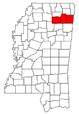
The Tupelo Micropolitan Statistical Area is a micropolitan area in northeastern Mississippi
that covers three counties - Itawamba
, Lee
and Pontotoc
. As of the 2000 census
, the μSA had a population of 125,251 (though a July 1, 2009 estimate placed the population at 134,161).
of 2000, there were 125,251 people, 48,070 households, and 34,881 families residing within the μSA. The racial makeup of the μSA was 79.37% White, 18.98% African American, 0.16% Native American, 0.37% Asian, 0.01% Pacific Islander, 0.47% from other races
, and 0.64% from two or more races. Hispanic or Latino of any race were 1.27% of the population.
The median income for a household in the μSA was $33,125, and the median income for a family was $39,929. Males had a median income of $29,781 versus $21,495 for females. The per capita income
for the μSA was $16,523.
Mississippi
Mississippi is a U.S. state located in the Southern United States. Jackson is the state capital and largest city. The name of the state derives from the Mississippi River, which flows along its western boundary, whose name comes from the Ojibwe word misi-ziibi...
that covers three counties - Itawamba
Itawamba County, Mississippi
In 2000, there were 8,773 households out of which 33.20% had children under the age of 18 living with them, 60.30% were married couples living together, 9.90% had a female householder with no husband present, and 25.90% were non-families. 23.40% of all households were made up of individuals and...
, Lee
Lee County, Mississippi
-National protected areas:* Brices Cross Roads National Battlefield Site* Natchez Trace Parkway * Tupelo National Battlefield-History:On September 20, 1816, General Andrew Jackson, David Meriwether, and the Chickasaw Nation signed the Treaty of Chickasaw Council House in Lee County.Lee County was...
and Pontotoc
Pontotoc County, Mississippi
-National protected area:* Natchez Trace Parkway * Tombigbee National Forest -Demographics:As of the census of 2000, there were 26,726 people, 10,097 households, and 7,562 families residing in the county. The population density was 54 people per square mile . There were 10,816 housing units at an...
. As of the 2000 census
United States Census, 2000
The Twenty-second United States Census, known as Census 2000 and conducted by the Census Bureau, determined the resident population of the United States on April 1, 2000, to be 281,421,906, an increase of 13.2% over the 248,709,873 persons enumerated during the 1990 Census...
, the μSA had a population of 125,251 (though a July 1, 2009 estimate placed the population at 134,161).
Counties
- ItawambaItawamba County, MississippiIn 2000, there were 8,773 households out of which 33.20% had children under the age of 18 living with them, 60.30% were married couples living together, 9.90% had a female householder with no husband present, and 25.90% were non-families. 23.40% of all households were made up of individuals and...
- LeeLee County, Mississippi-National protected areas:* Brices Cross Roads National Battlefield Site* Natchez Trace Parkway * Tupelo National Battlefield-History:On September 20, 1816, General Andrew Jackson, David Meriwether, and the Chickasaw Nation signed the Treaty of Chickasaw Council House in Lee County.Lee County was...
- PontotocPontotoc County, Mississippi-National protected area:* Natchez Trace Parkway * Tombigbee National Forest -Demographics:As of the census of 2000, there were 26,726 people, 10,097 households, and 7,562 families residing in the county. The population density was 54 people per square mile . There were 10,816 housing units at an...
Cities
- BaldwynBaldwyn, MississippiBaldwyn is a city in Lee and Prentiss Counties, Mississippi, United States. Baldwyn is located on Highway 370, due north of Tupelo, Mississippi. It was incorporated by Act of the Legislature in Tishomingo and Itawamba Counties on April 1, 1861...
(partial) - FultonFulton, MississippiFulton is a city in Itawamba County, Mississippi, United States. The population was 3,882 at the 2000 census. It is the county seat of Itawamba County.This city is part of the Tupelo Micropolitan Statistical Area.-Geography:...
- PontotocPontotoc, MississippiPontotoc is a city in Pontotoc County, Mississippi, United States. Pontotoc is west of the much larger city of Tupelo. The population was 5,625 at the 2010 census...
- TupeloTupelo, MississippiTupelo is the largest city in and the county seat of Lee County, Mississippi, United States. It is the seventh largest city in the state of Mississippi, smaller than Meridian, and larger than Greenville. As of the 2000 United States Census, the city's population was 34,211...
(Principal City) - VeronaVerona, MississippiVerona is a city in Lee County, Mississippi, United States. The population was 3,334 at the 2000 census.-Geography:Verona is located at ....
Towns
- AlgomaAlgoma, MississippiAlgoma is a town in Pontotoc County, Mississippi, United States. Algoma is a Native American word meaning "vale of flowers". The population was 508 at the 2000 census.-Geography:Algoma is located at ....
- EcruEcru, MississippiEcru is a town in Pontotoc County, Mississippi, United States. The population was 947 at the 2000 census.-Geography:Ecru is located at...
- GuntownGuntown, MississippiGuntown is a town in Lee County, Mississippi, United States. The population was 1,183 at the 2000 census.-Geography:Guntown is located at ....
- MantachieMantachie, MississippiMantachie is a town in Itawamba County, Mississippi, United States. The population was 1,107 at the 2000 census.-Geography:Mantachie is located at .According to the United States Census Bureau, the town has a total area of , all land.-Demographics:...
- NettletonNettleton, MississippiNettleton is a town in Lee and Monroe Counties in the U.S. state of Mississippi. The population was 1,932 at the 2000 census.-Geography:Nettleton is located at . The town sits on the boundary line between Lee County on the north and Monroe County on the south, with approximately equal portions of...
(partial) - PlantersvillePlantersville, MississippiPlantersville is a town in Lee County, Mississippi, United States. The population was 1,144 at the 2000 census.-Geography:Plantersville is located at ....
- SaltilloSaltillo, MississippiSaltillo is a town in Lee County, Mississippi, United States. The population was 3,393 at the 2000 census.-Geography:Saltillo is located at ....
- ShannonShannon, MississippiShannon is a town in Lee County, Mississippi, United States. The population was 1,657 at the 2000 census.-Geography:Shannon is located at .According to the United States Census Bureau, the town has a total area of , all of it land....
- ShermanSherman, MississippiSherman is a town which straddles Lee, Pontotoc, and Union counties in the U.S. state of Mississippi. The population was 548 at the 2000 census.-Geography:...
(partial) - ThaxtonThaxton, MississippiThaxton is a town in Pontotoc County, Mississippi, United States. The population was 513 at the 2000 census. There is a town of the same name in Virginia -Geography:Thaxton is located at ....
- ToccopolaToccopola, MississippiToccopola is a town in Pontotoc County, Mississippi, United States. The population was 189 at the 2000 census.-Geography:Toccopola is located at ....
- TremontTremont, MississippiTremont is town in Itawamba County, Mississippi, United States. It was founded in 1852. The population was 390 at the 2000 census. It was the birthplace of country music singer Tammy Wynette.-Geography:Tremont is located at ....
Unincorporated places
- Dorsey
- Fairview
- Mooreville
- RandolphRandolph, MississippiRandolph is a small community in Pontotoc, Mississippi. Highway 9 South runs through the center of Randolph. Mostly a farming and logging community, there are many farms and sawmills. Also, there is a large Amish community located here....
- Springville
- TroyTroy, MississippiTroy, Mississippi is an unincorporated hamlet in Pontotoc County, Mississippi, Mississippi, around the intersection of Mississippi Highway 41 and County Road 82, roughly two miles west of the Natchez Trace Parkway, due west of Shannon, Mississippi, at latitude 34.119 and longitude -88.885. The...
Demographics
As of the censusCensus
A census is the procedure of systematically acquiring and recording information about the members of a given population. It is a regularly occurring and official count of a particular population. The term is used mostly in connection with national population and housing censuses; other common...
of 2000, there were 125,251 people, 48,070 households, and 34,881 families residing within the μSA. The racial makeup of the μSA was 79.37% White, 18.98% African American, 0.16% Native American, 0.37% Asian, 0.01% Pacific Islander, 0.47% from other races
Race (United States Census)
Race and ethnicity in the United States Census, as defined by the Federal Office of Management and Budget and the United States Census Bureau, are self-identification data items in which residents choose the race or races with which they most closely identify, and indicate whether or not they are...
, and 0.64% from two or more races. Hispanic or Latino of any race were 1.27% of the population.
The median income for a household in the μSA was $33,125, and the median income for a family was $39,929. Males had a median income of $29,781 versus $21,495 for females. The per capita income
Per capita income
Per capita income or income per person is a measure of mean income within an economic aggregate, such as a country or city. It is calculated by taking a measure of all sources of income in the aggregate and dividing it by the total population...
for the μSA was $16,523.