

Tunnels in Iceland
Encyclopedia
Road
A road is a thoroughfare, route, or way on land between two places, which typically has been paved or otherwise improved to allow travel by some conveyance, including a horse, cart, or motor vehicle. Roads consist of one, or sometimes two, roadways each with one or more lanes and also any...
system. Tunnels in Iceland
Iceland
Iceland , described as the Republic of Iceland, is a Nordic and European island country in the North Atlantic Ocean, on the Mid-Atlantic Ridge. Iceland also refers to the main island of the country, which contains almost all the population and almost all the land area. The country has a population...
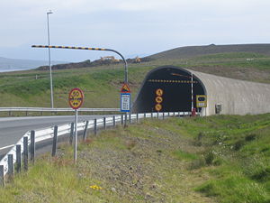
are usually built under mountains to prevent winter isolation of remote communities which would otherwise have to depend on high roads that often closed due to snow
Snow
Snow is a form of precipitation within the Earth's atmosphere in the form of crystalline water ice, consisting of a multitude of snowflakes that fall from clouds. Since snow is composed of small ice particles, it is a granular material. It has an open and therefore soft structure, unless packed by...
, to shorten distance between communities, and to increase road safety by bypassing dangerous stretches of road. A tunnel under a fjord
Fjord
Geologically, a fjord is a long, narrow inlet with steep sides or cliffs, created in a valley carved by glacial activity.-Formation:A fjord is formed when a glacier cuts a U-shaped valley by abrasion of the surrounding bedrock. Glacial melting is accompanied by rebound of Earth's crust as the ice...
, the Hvalfjörður Tunnel, is among the longest underwater road tunnels in the world, and goes as deep as 165 m (541 ft) below sea level.
Tunneling is a relatively recent trend in Icelandic road infrastructure. It started off slowly and was at first only used in extreme circumstances. The first was opened in 1967 and provided the northern town of Siglufjörður
Siglufjörður
Siglufjörður is a small fishing town in a narrow fjord with the same name on the northern coast of Iceland.Population in January 2011 was 1,206 but the town has been shrinking in size since the 1950s when the town reached its peak with 3,000 inhabitants....
with its first year-round road link to the rest of the country. The second tunnel, opened in 1977, replaced a difficult road over the mountain pass Oddsskarð in eastern Iceland which could only be used during the short summer and was the only road link to the town of Neskaupstaður
Neskaupstaður
Neskaupstaður is a town located on the fjord Norðfjörður on the eastern side of Iceland. It is part of the municipality of Fjarðabyggð and, as of 2011, it has a population of 1,437.-History:...
. The third tunnel was opened in 1992 and replaced a very hazardous mountainside road to the northern town of Ólafsfjörður
Ólafsfjörður
Ólafsfjörður is a town in the northeast of Iceland located at the mouth of the fjord Eyjafjörður.The town is connected to Eyjafjordur via a 3.5 km one-lane tunnel...
. All three of these tunnels were built as a single lane with widenings at regular intervals where vehicles coming from opposite directions can pass. As improved engineering methods made tunneling cheaper and Iceland became more prosperous in the 1990s, tunnels became viable options for places where they had not been considered before. In 1996 the Vestfjarðagöng tunnel opened in the Westfjords
Westfjords
The Westfjords or West Fjords is the name for the large peninsula in northwestern Iceland. It is connected to the rest of Iceland by a 7 km wide isthmus between Gilsfjörður and Bitrufjörður. The Westfjords are very mountainous; the coastline is heavily indented by dozens of fjords surrounded by...
region, it ended the winter isolation of three villages by linking them to the town of Ísafjörður
Ísafjörður
Ísafjörður is a town in the north west of Iceland, seat of Ísafjarðarbær municipality.The town draws its name from the fjord and the fjord was given its name simultaneously to the island...
. This tunnel was the last one built with single-lane segments.
In 1998 the sub-sea Hvalfjarðargöng opened, reducing the distance from Reykjavík to the town of Akranes by 60 kilometers and consequently abolishing the ferry service between the two. The distance between Reykjavík and other destinations on the north side of the fjord Hvalfjörðurwas reduced by 45 kilometers. It is the only tunnel in Iceland to have been financed, built and operated by a private entity and as such, is also the only tunnel where tolls are charged. The original plan assumed it would take 20 years (until 2018) to pay back the cost of building the tunnel and that the tunnel would be turned over to the state at that point but traffic has proved to be significantly higher than originally projected. So high in fact that the operator of the tunnel has suggested building a new tunnel alongside the current one since traffic is reaching the threshold mandated by European regulation (10,000 vehicles daily) where traffic in opposing directions is meant to be separated.
Five tunnels have opened since the turn of the century. The most recent to open are the Bolungarvíkurgöng on route 61 in Vestfirðir between Hnifsdalur and Bolungarvik, replacing the road which was often affected by rockfalls and avalanches and Héðinsfjarðargöng I and II on route 76 in Norðurland eystra
Norðurland eystra
Norðurland eystra is one of the traditional eight regions of Iceland, located on the northern side of the island. The biggest town in the region is Akureyri, with a population of 17,300. The name "Norðurland Eystra" means "The North-East Region"....
between the towns Ólafsfjörður
Ólafsfjörður
Ólafsfjörður is a town in the northeast of Iceland located at the mouth of the fjord Eyjafjörður.The town is connected to Eyjafjordur via a 3.5 km one-lane tunnel...
and Siglufjörður
Siglufjörður
Siglufjörður is a small fishing town in a narrow fjord with the same name on the northern coast of Iceland.Population in January 2011 was 1,206 but the town has been shrinking in size since the 1950s when the town reached its peak with 3,000 inhabitants....
, reducing the distance between the towns to 15km.
Key
| m | Metre |
| ft | Feet |
| * | Under construction |
| ** | In planning |
Tunnels
| Name | Length | Date of Opening | Region | Road # | |||
|---|---|---|---|---|---|---|---|
| Vestfjarðagöng Vestfjarðagöng Vestfjarðagöng is the longest tunnel in Iceland, located in Vestfirðir in northwestern Iceland. It has a length of and was opened in September 1996.... 3 |
9120 m (29,921 ft)1 | September 1996 | Vestfirðir | 60 and 65 | |||
| Vaðlaheiðargöng Vaðlaheiðargöng Vaðlaheiðargöng is a planned tunnel in Iceland, located in Norðurland eystra along Route 1, just East of Akureyri. It will have a length of . and replace a 21 km section of route 1 including the Víkurskard pass. The tunnel should be opened in 2014-2016.... ** |
7400 m (24,278 ft) | 2014-2016 | Norðurland eystra Norðurland eystra Norðurland eystra is one of the traditional eight regions of Iceland, located on the northern side of the island. The biggest town in the region is Akureyri, with a population of 17,300. The name "Norðurland Eystra" means "The North-East Region".... |
1 | |||
| Héðinsfjarðargöng Héðinsfjarðargöng Héðinsfjarðargöng are two road tunnels in northern Iceland, connecting Ólafsfjörður and Siglufjörður. They were opened on October 2, 2010. The total cost was around ISK 12 billion .-External links:**... I |
6910 m (22,671 ft) | October 2, 2010 | Norðurland eystra Norðurland eystra Norðurland eystra is one of the traditional eight regions of Iceland, located on the northern side of the island. The biggest town in the region is Akureyri, with a population of 17,300. The name "Norðurland Eystra" means "The North-East Region".... |
76 | |||
| Norðfjarðargöng Norðfjarðargöng Norðfjarðargöng is a tunnel under construction in Iceland, located in Austurland along Route 62. It will have a length of and is due to be completed in 2014.... ** |
6500 m (21,325 ft) | unknown | Austurland Austurland Austurland is a region in eastern Iceland. Its area is 22,721 km² and its population is 15,300. The biggest town in the region is Egilsstaðir, with a population of 2300. The oldest municipality in the Eastfjords is Seydisfjörðr municipality established 1895, with population of 706 the year... |
92 | |||
| Fáskrúðsfjarðargöng Fáskrúðsfjarðargöng Fáskrúðsfjarðargöng is a tunnel in Iceland, located in Austurland along Route 96. It has a length of and opened on September 9, 2005.... |
5850 m (19,193 ft) | September 9, 2005 | Austurland Austurland Austurland is a region in eastern Iceland. Its area is 22,721 km² and its population is 15,300. The biggest town in the region is Egilsstaðir, with a population of 2300. The oldest municipality in the Eastfjords is Seydisfjörðr municipality established 1895, with population of 706 the year... |
96 | |||
| Hvalfjörður Tunnel Hvalfjörður Tunnel Hvalfjörður Tunnel is a road tunnel under the Hvalfjörður fjord in Iceland and a part of the Route 1 . It is 5,762m long and reaches depth of 165m below sea level. Opened on 11 July 1998, it shortens the distance from Reykjavík to the western and northern parts of the island by 45 km... |
5770 m (18,930 ft) | July 1, 1998 | Greater Reykjavík Area Greater Reykjavík Area The Greater Reykjavík Area is a name used collectively for Reykjavík and seven municipalities around it.. The area is the largest urban area in Iceland. Each municipality has its independent elected council. With a population of 200,852, the Greater Reykjavík Area comprises over 60% of the... — Vesturland Vesturland Vesturland is one of the traditional eight regions of Iceland, located on the western side of the island. The biggest town in the region is Akranes, with a population of 6300.... |
1 Route 1 (Iceland) Route 1 or the Ring Road is a main road in Iceland that runs around the island and connects all habitable parts of the country . The total length of the road is .... |
|||
| Between Arnarfjörður and Dýrafjörður** | 5600 m (18,373 ft) | unknown | Vestfirðir | 60 | |||
| Bolungarvíkurgöng Bolungarvíkurgöng Bolungarvíkurgöng is a tunnel in northwestern Iceland, located in Vestfirðir along Route 61. It has a length of and opened on September 25, 2010.... |
5156 m (16,916 ft) | September 25, 2010 | Vestfirðir | 61 | |||
| Héðinsfjarðargöng Héðinsfjarðargöng Héðinsfjarðargöng are two road tunnels in northern Iceland, connecting Ólafsfjörður and Siglufjörður. They were opened on October 2, 2010. The total cost was around ISK 12 billion .-External links:**... II |
3650 m (11,975 ft) | October 2, 2010 | Norðurland eystra Norðurland eystra Norðurland eystra is one of the traditional eight regions of Iceland, located on the northern side of the island. The biggest town in the region is Akureyri, with a population of 17,300. The name "Norðurland Eystra" means "The North-East Region".... |
76 | |||
| Múlagöng Múlagöng Múlagöng is a tunnel in Iceland, located in Norðurland eystra along Route 82. It has a length of and was opened on March 1, 1991.... 2 |
3400 m (11,155 ft) | March 1, 1991 | Norðurland eystra Norðurland eystra Norðurland eystra is one of the traditional eight regions of Iceland, located on the northern side of the island. The biggest town in the region is Akureyri, with a population of 17,300. The name "Norðurland Eystra" means "The North-East Region".... |
82 | |||
| Almannaskarðsgöng Almannaskarðsgöng Almannaskarðsgöng is a tunnel along Route 1, located near Höfn in Austurland in eastern Iceland. The tunnel measures 1312 metres exactly in length and was opened on June 24, 2005... |
1308 m (4,291 ft) | June 24, 2005 | Austurland Austurland Austurland is a region in eastern Iceland. Its area is 22,721 km² and its population is 15,300. The biggest town in the region is Egilsstaðir, with a population of 2300. The oldest municipality in the Eastfjords is Seydisfjörðr municipality established 1895, with population of 706 the year... |
1 Route 1 (Iceland) Route 1 or the Ring Road is a main road in Iceland that runs around the island and connects all habitable parts of the country . The total length of the road is .... |
|||
| Strákagöng Strákagöng Strákagöng is a tunnel in Iceland, located in Norðurland vestra along Route 76. It has a length of and was opened in 1967.... 2 |
800 m (2,625 ft) | 1967 | Norðurland vestra Norðurland vestra Norðurland vestra is one of the traditional eight regions of Iceland, located on the northern side of the island. The biggest town in the region is Sauðárkrókur, with a population of 3000.... |
76 | |||
| Oddskarðsgöng Oddskarðsgöng Oddskarðsgöng is a tunnel in Iceland, located in Austurland along Route 92. It has a length of and was opened in 1977.... 2 |
640 m (2,100 ft) | 1977 | Austurland Austurland Austurland is a region in eastern Iceland. Its area is 22,721 km² and its population is 15,300. The biggest town in the region is Egilsstaðir, with a population of 2300. The oldest municipality in the Eastfjords is Seydisfjörðr municipality established 1895, with population of 706 the year... |
92 | |||
| Arnardalshamar Tunnel Arnardalshamar Tunnel Arnardalshamar Tunnel is a tunnel in Iceland, located in Vestfirðir along Route 61. It has a length of and was opened in 1948.... |
30 m (98 ft) | 1948 | Vestfirðir | 61 | |||
| Source: | |||||||
1 The tunnel has three branches that connect in a 3-way junction
3-way junction
A 3-way junction is a type of road junction with three arms. A Y junction generally has 3 arms of equal size...
inside the tunnel
2Single lane with widenings for passing.
3One branch of the tunnel has two lanes while two branches have a single lane with widenings for passing.