
Tuensang
Encyclopedia
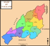
Tuensang [District Headquarter - Tuensang], the easternmost and the largest district of Nagaland
bordering with Myanmar. The town was founded in 1947 for the purpose of administrating the erstwhile North Eastern Frontier Agency (NEFA) that comprised the present day Tuensang, Mon, Longleng and Kiphire districts. Nowadays, this four districts combined together is also known as Eastern Nagaland. It is located at an altitude of 1,371 metres above sea level.
. Even after the British conquest of India, the Tuensang tribal region remained unadministered due to lack of sufficient men and money. However in 1902, the area was brought under the nominal control of the British. It was called Tribal Area and was administered by the Governor General of India. In 1948, a separate division called Tuensang Administrative Circle was created.
When the Constitution of India
was first released in 1950, Tuensang Division was placed in "Part B" category of tribal districts as per the Sixth Schedule. It became part of the North-East Frontier Agency
(NEFA). Subsequently in 1957, it was merged with the Naga Hills District
to form a new administrative unit under the Ministry of External Affairs
. After negotiation with the secessionists, this administrative unit was later made a full-fleged state called Nagaland
.
 Tuensang is located at 26.28°N 94.83°E. It has an average elevation of 1371 metres (4498 feet).
, Tuensang had a population of 29,654. Males constitute 56% of the population and females 44%. Tuensang has an average literacy rate of 71%, higher than the national average of 59.5%: male literacy is 74%, and female literacy is 67%. In Tuensang, 13% of the population is under 6 years of age.
Tuensang is one of the largest urban centre in Nagaland along with Dimapur, Kohima and Mokokchung. The Land-owners/Permanent Tribes of the district are Changs
, Sangtams, Yimchunger
s and Khiamniungans. The Tuensang town serves like a nerve center of the Eastern part (which comprises four districts i.e. Tuensang, Mon, Kiphire and Longleng with six major tribes) of Nagaland state. Since Tuensang Town is the Headquarters to several apex organisations such as Eastern Nagaland Peoples' Organisation (ENPO), Eastern Naga Students' Federation (ENSF), Chang Khulei Setshang (CKS), Confederation of Chang Students' Union (CCSU), Chang Baptist Lashong Thangyen (CBLT), Eleutheros Christian Society (ECS), Eastern Farming Association, etc.
Colleges
The district is also provided with a National Highways-155 which links with Mokokchung (NH-61 junction) and Jessami (NH-150 junction) via Tuensang Town, covering a distance of 342 km. Recently the on-going works on NH-155 came under severe criticisms from the public led by Eastern Naga Students' Federation for alleged poor workmanship and non adherence to contract norms by the contractors and lackadaisical attitude of the Nagaland Public Works Department [3,4,5].
Nagaland
Nagaland is a state in the far north-eastern part of India. It borders the state of Assam to the west, Arunachal Pradesh and part of Assam to the north, Burma to the east and Manipur to the south. The state capital is Kohima, and the largest city is Dimapur...
bordering with Myanmar. The town was founded in 1947 for the purpose of administrating the erstwhile North Eastern Frontier Agency (NEFA) that comprised the present day Tuensang, Mon, Longleng and Kiphire districts. Nowadays, this four districts combined together is also known as Eastern Nagaland. It is located at an altitude of 1,371 metres above sea level.
History
The Tuensang area was originally made up of all the present four districts of Eastern NagalandNagaland
Nagaland is a state in the far north-eastern part of India. It borders the state of Assam to the west, Arunachal Pradesh and part of Assam to the north, Burma to the east and Manipur to the south. The state capital is Kohima, and the largest city is Dimapur...
. Even after the British conquest of India, the Tuensang tribal region remained unadministered due to lack of sufficient men and money. However in 1902, the area was brought under the nominal control of the British. It was called Tribal Area and was administered by the Governor General of India. In 1948, a separate division called Tuensang Administrative Circle was created.
When the Constitution of India
Constitution of India
The Constitution of India is the supreme law of India. It lays down the framework defining fundamental political principles, establishes the structure, procedures, powers, and duties of government institutions, and sets out fundamental rights, directive principles, and the duties of citizens...
was first released in 1950, Tuensang Division was placed in "Part B" category of tribal districts as per the Sixth Schedule. It became part of the North-East Frontier Agency
North-East Frontier Agency
The North-East Frontier Agency was one of the political divisions in British India and later the Republic of India till 1972, when it became the Union Territory of Arunachal Pradesh...
(NEFA). Subsequently in 1957, it was merged with the Naga Hills District
Naga Hills District, British India
The Naga Hills District was a former district of the Assam province of British India. Located in the Naga Hills, it was mainly inhabitated by the Naga tribes. The area is now part of the Nagaland state.- History :...
to form a new administrative unit under the Ministry of External Affairs
Ministry of External Affairs (India)
The Ministry of External Affairs is the foreign ministry of India. It is the Indian government agency responsible for the foreign relations of India. The Minister of External Affairs holds cabinet rank as a member of the Council of Ministers. The current minister is S M Krishna...
. After negotiation with the secessionists, this administrative unit was later made a full-fleged state called Nagaland
Nagaland
Nagaland is a state in the far north-eastern part of India. It borders the state of Assam to the west, Arunachal Pradesh and part of Assam to the north, Burma to the east and Manipur to the south. The state capital is Kohima, and the largest city is Dimapur...
.
Geography
Demographics
India censusCensus
A census is the procedure of systematically acquiring and recording information about the members of a given population. It is a regularly occurring and official count of a particular population. The term is used mostly in connection with national population and housing censuses; other common...
, Tuensang had a population of 29,654. Males constitute 56% of the population and females 44%. Tuensang has an average literacy rate of 71%, higher than the national average of 59.5%: male literacy is 74%, and female literacy is 67%. In Tuensang, 13% of the population is under 6 years of age.
Tuensang is one of the largest urban centre in Nagaland along with Dimapur, Kohima and Mokokchung. The Land-owners/Permanent Tribes of the district are Changs
Chang Naga
Chang is a Naga of Nagaland, India. It is one of the recognized Scheduled Tribes.The tribe was also known as Mazung in British India. Other Naga tribes know the Changs by different names including Changhai , Changru , Duenching , Machungrr , Mochumi and Mojung .- Origin :According to oral...
, Sangtams, Yimchunger
Yimchunger
- History :According to the Yimchunger tradition, the tribe emerged at a village called Moru, and then came to the Jure village. The Yimchungers and the Khiamungans are believed to have migrated to the present-day Nagaland from Upper Burma as one group, in one wave...
s and Khiamniungans. The Tuensang town serves like a nerve center of the Eastern part (which comprises four districts i.e. Tuensang, Mon, Kiphire and Longleng with six major tribes) of Nagaland state. Since Tuensang Town is the Headquarters to several apex organisations such as Eastern Nagaland Peoples' Organisation (ENPO), Eastern Naga Students' Federation (ENSF), Chang Khulei Setshang (CKS), Confederation of Chang Students' Union (CCSU), Chang Baptist Lashong Thangyen (CBLT), Eleutheros Christian Society (ECS), Eastern Farming Association, etc.
Educational institutions
- Government Higher Secondary School
- St. John's High School
- Christ King School
- St. Joseph's School
- Thangjem High School
- Chaba School
- St. Xavier School
- St. Anthony School
- Holy Angel School
- Little Flower School
- Akum Imlong School
- Loyem Memorial School
- Thangyen School
- Montessori Kids Care School
- Assam Rifles School
- National Institute of Open Schooling
- Holy Cross School Saksi
- Eklavya Model Residential School Saksi
- 3rd Battalion N.A.P School Saksi
- Jawahar Navodaya Vidyalaya Chare
- Government High School Noksen
- Government Higher Secondary School Noklak
- Christian High school Shamator
- Government High School Shamator
Colleges
- Sao Chang College
- Loyem Memorial College
- District Institute of Teachers' Education
- Imlong Theological College Saksi
- Oriental Theological College Yangli
- IGNOU Study Center
Public utilities
The district also has a functional 100 bedded Civil Hospital which has been upgraded to Regional Diagnostic Center (RDC) but RDC is yet to be operationalised. The district also has an Agriculture Science Center known as KVK, an undertaking of the Government of India, Badminton Stadium, Town Hall and a Public Ground. The "Longpang Project" a program managed by Eleutheros Christian Society (ECS) in collaborations with other government and private agencies, situated nearby Hakchang Village has one Health Center which also runs the only Rehabilitation Center in the district that takes care of AIDS patients and Drug addicts.The district is also provided with a National Highways-155 which links with Mokokchung (NH-61 junction) and Jessami (NH-150 junction) via Tuensang Town, covering a distance of 342 km. Recently the on-going works on NH-155 came under severe criticisms from the public led by Eastern Naga Students' Federation for alleged poor workmanship and non adherence to contract norms by the contractors and lackadaisical attitude of the Nagaland Public Works Department [3,4,5].