
Trigo Mountains
Encyclopedia
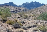
The Trigo Mountains is a north-south trending mountain range, bordering the Colorado River
on the east in the Lower Colorado River Valley
and lies north of the Colorado River as it turns east, north of Martinez Lake
and the Imperial Reservoir
. The Trigo Mountains are on a north-south stretch of the Colorado River, and form the eastern perimeter of the Imperial National Wildlife Refuge
.
, and the arc-curving ranges would be presumed to be a resultant of the same time-framed thrust-faulting event during the formation of the Basin and Range
province.
The highest peak of the Trigos is Mohave Peak at 2771 feet (845 m) in the southeast, isolated from the main trend of the range. The largest peak that terminates the mountain range in the north is unnamed, at 2170 feet (661 m) as part of the North Trigo Peaks.
, and then a 4-wheel drive dirt road to the Red Cloud Mine. Access to the northern regions is more general, by way of the valley containing the Colorado River Indian Reservation
on the east bank of the river in Arizona.
Blythe
, California is 12 miles (19 km) northwest of the northern ranges; Yuma
, Arizona-Winterhaven
, California are about 30 miles (48 km) south of the central range.
Colorado River
The Colorado River , is a river in the Southwestern United States and northwestern Mexico, approximately long, draining a part of the arid regions on the western slope of the Rocky Mountains. The watershed of the Colorado River covers in parts of seven U.S. states and two Mexican states...
on the east in the Lower Colorado River Valley
Lower Colorado River Valley
The Lower Colorado River Valley is the river region of the lower Colorado River of the southwestern United States in North America that rises in the Rocky Mountains and has its outlet at the Colorado River Delta in the northern Sea of Cortez in northwestern Mexico, between the states of Baja...
and lies north of the Colorado River as it turns east, north of Martinez Lake
Martinez Lake
Martinez Lake is a lake in the southwestern corner of the U.S. state of Arizona, about 60 miles north of Yuma, Arizona on the Lower Colorado River...
and the Imperial Reservoir
Imperial Reservoir
The Imperial Reservoir is an artificial lake formed by the construction of the Imperial Diversion Dam across the Colorado River in the Lower Colorado River Valley of Imperial County, California, and Yuma County, Arizona...
. The Trigo Mountains are on a north-south stretch of the Colorado River, and form the eastern perimeter of the Imperial National Wildlife Refuge
Imperial National Wildlife Refuge
The Imperial National Wildlife Refuge protects wildlife habitat along of the lower Colorado River in Arizona and California, including the last un-channeled section before the river enters Mexico...
.
Specifics of the range
The Trigo Mountains are north-south trending with the northern and central range arcing to the northeast. The curving range parallels the similar-(half the size) curving range to the southeast, the Chocolate MountainsChocolate Mountains (Arizona)
The Chocolate Mountains of Arizona are located in the southwestern part of the state east of the Trigo Mountains and southwest of the Kofa National Wildlife Refuge. The mountains are located about 30 miles east of the Chocolate Mountains of California, but the two ranges are not connected. The...
, and the arc-curving ranges would be presumed to be a resultant of the same time-framed thrust-faulting event during the formation of the Basin and Range
Basin and Range
The Basin and Range Province is a vast physiographic region defined by a unique topographic expression. Basin and Range topography is characterized by abrupt changes in elevation, alternating between narrow faulted mountain chains and flat arid valleys or basins...
province.
The highest peak of the Trigos is Mohave Peak at 2771 feet (845 m) in the southeast, isolated from the main trend of the range. The largest peak that terminates the mountain range in the north is unnamed, at 2170 feet (661 m) as part of the North Trigo Peaks.
Access
Access from the south is made at the Colorado River at Martinez LakeMartinez Lake
Martinez Lake is a lake in the southwestern corner of the U.S. state of Arizona, about 60 miles north of Yuma, Arizona on the Lower Colorado River...
, and then a 4-wheel drive dirt road to the Red Cloud Mine. Access to the northern regions is more general, by way of the valley containing the Colorado River Indian Reservation
Colorado River Indian Reservation
The Colorado River Indian Reservation is 189 miles west of Phoenix, Arizona, on highway 95. It lies in western La Paz County, Arizona, southeastern San Bernardino County, California, and northeastern Riverside County, California. It has a total land area of 432.22 sq mi , and most of it lies...
on the east bank of the river in Arizona.
Blythe
Blythe, California
Blythe is a city in Riverside County, California, United States, in the "Palo Verde Valley" of the Lower Colorado River Valley region, an agricultural area and part of the Colorado Desert along the Colorado River. Blythe was named after Thomas Blythe, a gold prospector who established primary...
, California is 12 miles (19 km) northwest of the northern ranges; Yuma
Yuma, Arizona
Yuma is a city in and the county seat of Yuma County, Arizona, United States. It is located in the southwestern corner of the state, and the population of the city was 77,515 at the 2000 census, with a 2008 Census Bureau estimated population of 90,041....
, Arizona-Winterhaven
Winterhaven, California
Winterhaven is a census-designated place in Imperial County, California. Winterhaven is located east of Pilot Knob, The population was 394 at the 2010 census, down from 529 at the 2000 census. It is part of the 'El Centro, California Metropolitan Statistical Area'...
, California are about 30 miles (48 km) south of the central range.
See also
- List of mountain ranges of La Paz County, Arizona
- List of mountain ranges of Arizona
- Trigo Mountains WildernessTrigo Mountains WildernessTrigo Mountains Wilderness is a wilderness area in the U.S. state of Arizona and was established in 1990. It is located north of Yuma east of the Colorado River in an area called the Lower Colorado River Valley. It is a stretch of ridgeline of the rugged desert Trigo Mountains and is adjacent to...