
Toodyay, Western Australia
Encyclopedia
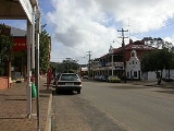
Toodyay is a town located in the Wheatbelt
region in the Avon Valley
, 85 km north-east of Perth
, Western Australia
. Toodyay is connected to Perth via both rail and road.
 The original village of Toodyay was one of the earliest inland towns in the State, established along the Avon River
in 1836 after settlers including James Drummond
, Captain Francis Whitfield and Alexander Anderson explored the area; Drummond established his homestead Hawthornden nearby. However, the location was subject to flooding which led to its abandonment in the 1850s, and a new townsite was established on higher ground 2 km upstream. This was gazetted in 1860 as 'Newcastle' and the original settlement came to be referred to as 'Old Toodyay'. In May 1910 due to confusion with the New South Wales
city of Newcastle
, Newcastle became known as 'Toodyay', and the original townsite, which had by this time declined substantially, became 'West Toodyay'.
The meaning of the name is uncertain, although it is Noongar
Indigenous
in origin - maps in 1836 referred to "Duidgee", while some believe it was named for a local woman named Toodyeep who accompanied early explorers in the area. Another source suggests it could mean "place of plenty". The name "Duidgee" is preserved in the riverside recreation area, "Duidgee Park".
In 1861, Western Australia's best known bushranger
, Moondyne Joe
, was imprisoned in Toodyay for stealing a horse, but escaped. After a series of crimes and jail terms, he was on the run again, returning to Toodyay in 1865 to steal supplies for an attempt to escape overland to South Australia. The annual Moondyne Festival is a light-hearted celebration of this darker side of Toodyay's history.
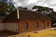
The Newcastle Gaol, in Clinton Street, was completed in 1864 and in use as a state gaol until 1909. It is now preserved as the Old Gaol Museum
; an historic building and tourist attraction.
In 1870, a steam-driven flour mill, Connor's Mill
, was built on Stirling Terrace by George Hasell. The mill was also used to generate electricity in the early part of the twentieth century. Saved from demolition in the 1970s, and restored to demonstrate the milling process and machinery, the mill now forms the museum section of the Toodyay Visitors Centre.
The Heritage Council of Western Australia
lists well over one hundred places of historical significance in or near Toodyay, including cottages (some of which are now ruins), homesteads, shops, churches, parks and railway constructions.
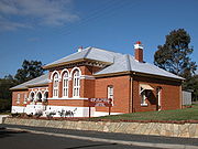
The State Register of Heritage Buildings includes the Gaol, Connor's Mill, Toodyay Public Library (built 1874), the old Toodyay Post Office (designed by George Temple-Poole
, built 1897) and the old Toodyay Fire Station (designed by Ken Duncan, built 1938), as well as several other historic sites in Toodyay. Some of the historic architecture of shops and residences along Stirling Terrace, the main street, form a distinctive frontage described as the Stirling Terrace Streetscape Group.
A number of the above historic buildings are listed on the Australian Heritage Database. Other buildings listed include Freemasons Hotel (built 1861), Victoria Hotel (built late 1890s) and Old Unwins Store on Stirling Terrace, and Butterly's Cottage (built c. 1870) in Harper Road.
/ Toodyay / Chittering Valley and Great Northern Highway
- is a favourite with motorcyclists. On most weekends, Toodyay's main street is lined with cruisers and sportsbikes of many models, makes and vintages, their riders relaxing in the increasing number of pavement cafes that are springing up to accommodate the burgeoning tourist trade.
Toodyay also serves as a stop on the Avonlink
and Prospector
passenger trains from Perth
to Northam
and Kalgoorlie
.
) on 29 December after temperatures reached 45.4 °C (113.7 °F) and the "catastrophic" fire risk rating had been used for the first time in the state, affected areas to the south, south-west and east of the town of Toodyay, with more than 3000 hectares (7,413.2 acre) of forest burnt and 37 homes lost. The main impact of the fire appeared to be in the area of Stirlingia and Adenanthus Drives (31.583°N 116.446°W), although warnings had also been issued for the Wicklow Estate to the east of town, and Dumbarton Road to the south-east.
Wheatbelt
A wheat belt is an agricultural region predominantly dedicated to the growing of wheat--98.77.166.159 23:27, 21 November 2011 also has lots of corn and crops to deal with to.It may more specifically refer to:* Wheat belt...
region in the Avon Valley
Avon Valley, Western Australia
Avon Valley may refer to:* the fertile land in the catchment of the Avon River * the Avon Valley National Park* the final Eastern Railway route through the valley* Avon Valley School...
, 85 km north-east of Perth
Perth, Western Australia
Perth is the capital and largest city of the Australian state of Western Australia and the fourth most populous city in Australia. The Perth metropolitan area has an estimated population of almost 1,700,000....
, Western Australia
Western Australia
Western Australia is a state of Australia, occupying the entire western third of the Australian continent. It is bounded by the Indian Ocean to the north and west, the Great Australian Bight and Indian Ocean to the south, the Northern Territory to the north-east and South Australia to the south-east...
. Toodyay is connected to Perth via both rail and road.
History
Avon River (Western Australia)
The Avon River is a river in Western Australia. It is a tributary of the Swan River totalling 280 kilometres in length, with a catchment area of 125,000 square kilometres.-Catchment area:...
in 1836 after settlers including James Drummond
James Drummond (botanist)
James Drummond was a botanist and naturalist who was an early settler in Western Australia.-Early life:...
, Captain Francis Whitfield and Alexander Anderson explored the area; Drummond established his homestead Hawthornden nearby. However, the location was subject to flooding which led to its abandonment in the 1850s, and a new townsite was established on higher ground 2 km upstream. This was gazetted in 1860 as 'Newcastle' and the original settlement came to be referred to as 'Old Toodyay'. In May 1910 due to confusion with the New South Wales
New South Wales
New South Wales is a state of :Australia, located in the east of the country. It is bordered by Queensland, Victoria and South Australia to the north, south and west respectively. To the east, the state is bordered by the Tasman Sea, which forms part of the Pacific Ocean. New South Wales...
city of Newcastle
Newcastle, New South Wales
The Newcastle metropolitan area is the second most populated area in the Australian state of New South Wales and includes most of the Newcastle and Lake Macquarie Local Government Areas...
, Newcastle became known as 'Toodyay', and the original townsite, which had by this time declined substantially, became 'West Toodyay'.
The meaning of the name is uncertain, although it is Noongar
Noongar
The Noongar are an indigenous Australian people who live in the south-west corner of Western Australia from Geraldton on the west coast to Esperance on the south coast...
Indigenous
Indigenous Australians
Indigenous Australians are the original inhabitants of the Australian continent and nearby islands. The Aboriginal Indigenous Australians migrated from the Indian continent around 75,000 to 100,000 years ago....
in origin - maps in 1836 referred to "Duidgee", while some believe it was named for a local woman named Toodyeep who accompanied early explorers in the area. Another source suggests it could mean "place of plenty". The name "Duidgee" is preserved in the riverside recreation area, "Duidgee Park".
In 1861, Western Australia's best known bushranger
Bushranger
Bushrangers, or bush rangers, originally referred to runaway convicts in the early years of the British settlement of Australia who had the survival skills necessary to use the Australian bush as a refuge to hide from the authorities...
, Moondyne Joe
Moondyne Joe
Joseph Bolitho Johns , better known as Moondyne Joe, was Western Australia's best known bushranger.- Biography :...
, was imprisoned in Toodyay for stealing a horse, but escaped. After a series of crimes and jail terms, he was on the run again, returning to Toodyay in 1865 to steal supplies for an attempt to escape overland to South Australia. The annual Moondyne Festival is a light-hearted celebration of this darker side of Toodyay's history.
The Newcastle Gaol, in Clinton Street, was completed in 1864 and in use as a state gaol until 1909. It is now preserved as the Old Gaol Museum
Old Gaol Museum
The Newcastle Gaol Museum is a prison museum in Toodyay Western Australia.-History:In the early days of settlement the Military and the Resident Magistrate were stationed at York. 'Crimes' at his time were mostly stealing of livestock...
; an historic building and tourist attraction.
In 1870, a steam-driven flour mill, Connor's Mill
Connor's Mill
Connor's Mill is a steam driven flour mill located on Stirling Terrace, Toodyay, Western Australia. Still operational, the Shire of Toodyay protected the then dilapidated building in 1975 and established the Toodyay Tourist Centre. It is now one of the town's main tourist attractions.-History:The...
, was built on Stirling Terrace by George Hasell. The mill was also used to generate electricity in the early part of the twentieth century. Saved from demolition in the 1970s, and restored to demonstrate the milling process and machinery, the mill now forms the museum section of the Toodyay Visitors Centre.
The Heritage Council of Western Australia
Heritage Council of Western Australia
The Heritage Council of Western Australia is the Government of Western Australia agency created to identify, conserve and promote places of cultural heritage significance in the state.It was created under the Heritage of Western Australia Act...
lists well over one hundred places of historical significance in or near Toodyay, including cottages (some of which are now ruins), homesteads, shops, churches, parks and railway constructions.
The State Register of Heritage Buildings includes the Gaol, Connor's Mill, Toodyay Public Library (built 1874), the old Toodyay Post Office (designed by George Temple-Poole
George Temple-Poole
George Thomas Temple-Poole was a British architect and public servant, primarily known for his work in Western Australia from 1886....
, built 1897) and the old Toodyay Fire Station (designed by Ken Duncan, built 1938), as well as several other historic sites in Toodyay. Some of the historic architecture of shops and residences along Stirling Terrace, the main street, form a distinctive frontage described as the Stirling Terrace Streetscape Group.
A number of the above historic buildings are listed on the Australian Heritage Database. Other buildings listed include Freemasons Hotel (built 1861), Victoria Hotel (built late 1890s) and Old Unwins Store on Stirling Terrace, and Butterly's Cottage (built c. 1870) in Harper Road.
Transport
Toodyay, being an historic township and an hour's distance from Perth, is a venue for daytrippers, tourists and motorcyclists. The circuit - Toodyay Road through GidgegannupGidgegannup, Western Australia
Gidgegannup is a township northeast of Perth, the capital city of Western Australia. The name Gidgegannup comes from a Noongar word meaning "Place where spears are made", and was first recorded by passing surveyors in 1852....
/ Toodyay / Chittering Valley and Great Northern Highway
Great Northern Highway
The Great Northern Highway is a generally north-south Western Australian highway which links the state's capital Perth with its most northern port, Wyndham. It is in length, with being National Highway...
- is a favourite with motorcyclists. On most weekends, Toodyay's main street is lined with cruisers and sportsbikes of many models, makes and vintages, their riders relaxing in the increasing number of pavement cafes that are springing up to accommodate the burgeoning tourist trade.
Toodyay also serves as a stop on the Avonlink
Transwa Avonlink
The AvonLink is a standard gauge passenger train operated by Transwa that operates between Perth, Western Australia and the Avon Valley. It provides one service in each direction every weekday, to and from the regional town of Northam, and since 2004, has provided three extended services a week to...
and Prospector
Transwa Prospector
The Transwa Prospector is a standard-gauge passenger train operated by Transwa that runs between Perth, Western Australia, and the Goldfields town of Kalgoorlie.-History:...
passenger trains from Perth
Perth, Western Australia
Perth is the capital and largest city of the Australian state of Western Australia and the fourth most populous city in Australia. The Perth metropolitan area has an estimated population of almost 1,700,000....
to Northam
Northam, Western Australia
Northam is a town in Western Australia, situated at the confluence of the Avon and Mortlock Rivers, about north-east of Perth in the Avon Valley. At the 2006 census, Northam had a population of 6,009. Northam is the largest town in the Avon region...
and Kalgoorlie
Kalgoorlie, Western Australia
Kalgoorlie, known as Kalgoorlie-Boulder, is a town in the Goldfields-Esperance region of Western Australia, and is located east-northeast of state capital Perth at the end of the Great Eastern Highway...
.
Tourist Attractions
Toodyay has a number of tourist attractions, including olive oil farms, lavender farms, holiday retreats, hotels, caravan parks and an archery park.2009 bushfire
A major bushfire on 29–30 December 2009, which broke out at approximately midday (AWSTAWST
AWST may refer to:* Australian Western Standard Time. See Time in Australia* Aviation Week & Space Technology...
) on 29 December after temperatures reached 45.4 °C (113.7 °F) and the "catastrophic" fire risk rating had been used for the first time in the state, affected areas to the south, south-west and east of the town of Toodyay, with more than 3000 hectares (7,413.2 acre) of forest burnt and 37 homes lost. The main impact of the fire appeared to be in the area of Stirlingia and Adenanthus Drives (31.583°N 116.446°W), although warnings had also been issued for the Wicklow Estate to the east of town, and Dumbarton Road to the south-east.