
Tongariro Northern Circuit
Encyclopedia
New Zealand Great Walks
The New Zealand Great Walks are a set of popular tramping tracks. They are New Zealand's premier tracks, through areas of some of the best scenery in the country...
, is a three to four day tramp in Tongariro National Park
Tongariro National Park
Tongariro National Park is the oldest national park in New Zealand, located in the central North Island. It has been acknowledged by UNESCO as one of the 28 mixed cultural and natural World Heritage Sites....
, New Zealand
New Zealand
New Zealand is an island country in the south-western Pacific Ocean comprising two main landmasses and numerous smaller islands. The country is situated some east of Australia across the Tasman Sea, and roughly south of the Pacific island nations of New Caledonia, Fiji, and Tonga...
. Part of it is the famous Tongariro Alpine Crossing, a day's march that incorporates the Northern Circuit's most stunning scenery. The complete trail forms a 50 kilometres long loop trail that circumnavigates Mount Ngauruhoe
Mount Ngauruhoe
Mount Ngauruhoe is an active stratovolcano or composite cone in New Zealand, made from layers of lava and tephra. It is the youngest vent in the Tongariro volcanic complex on the Central Plateau of the North Island, and first erupted about 2,500 years ago...
. Approximately 7,000 trampers complete the walk each year. This compares to the approximately 25,000 who walk only the Tongariro Crossing section.
When to Go
The best time to go is during the summer months (from December to March). It is important to get information about the weather beforehand. Heavy rain can cause small rivers and therefore complicate the progress of the march significantly, some alpine parts are also quite exposed. Moreover the beautiful scenery will be missed. Mountaineering equipment is required during the winter.Accommodation
There are four New Zealand Department of ConservationNew Zealand Department of Conservation
The Department of Conservation , commonly known by its acronym, "DOC", is the state sector organisation which deals with the conservation of New Zealand’s natural and historic heritage...
(DOC) huts around the circuit - Mangatepopo, Ketetahi, Oturere and Waihohonu. Since this is nominated a Great Walk, you must pay in advance to stay in the huts or the nearby campsites. This applies to the summer season from October 1 to April 30, during the other time these huts become backcountry huts, which can be used with a cheaper annual hut pass. It is forbidden to camp within 500 metres off the track.
Tour Guide
The Northern Circuit is a round trip that can be walked either way. The tour below describes the clockwise route starting in Whakapapa Village. There is a car park and a DOC Visitor Center where all necessary information is available. There are other possible starting points from various road ends along the track.Whakapapa Village to Mangatepopo Hut
Day One, 3-5 hours, 8.5 km.Starting the track at the Whakapapa Visitor Centre, it follows mainly the Whakapapa track over eroded plains. It crosses many smaller river beds and can be fairly muddy during rain. On the right side the cone of the volcano Mount Ngauruhoe is visible. The Mangatepopo Hut is 5 minutes off the main track.
Mangatepopo Hut to Ketetahi Hut
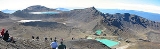
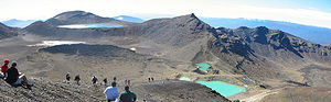
Day Two, 5-6 hours, 9 km.This is the actual Tongariro Alpine Crossing. Starting gently up the Mangatepopo river valley it becomes a steep climb on magmatic rock. It continues through the South Crater up and over the side of Red Crater and down to the Emerald Lakes. During the walk there are picturesque views of the active volcanic scenery, weather permitting. At the Emerald Lakes, named after their colour due to minerals from thermal area, the track joins the route to Oturere Hut (1 hours 30 minutes). After the lakes, the route passes Blue Lake before descending down to Ketetahi Hut.
Ketetahi Hut to Waihohonu Hut
Day Three, 6-7 hours, 16.5 km.The day begins with a moderate climb back to Emerald Lakes then down a relatively steep descent to Oturere Hut. One can see many abstractly formed lava formations on the way. Passing Oturere Hut the track fades into field of gravel lacking vegetation. The day finishes with a valley crossing and ascent through forest, then a descent to Waihohonu hut.
Waihohonu Hut to Whakapapa
Day Four, 5½–6 hours, 14 km.The track follows an old pack route beside Waihohonu Stream without much climbing. On the way there are side trips to the Lower and Upper Tama Lakes (20 minutes and 90 minutes return), formed by water filled volcanic craters. Just before Whakapapa the Taranaki Falls form a 5 minute detour from the main track.