
Tobago Cays
Encyclopedia
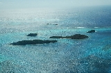
The Tobago Cays are an archipelago comprising five small uninhabited islands - Petit Rameau, Petit Bateau, Baradol, Petit Tobac and Jamesby - located in the Southern Grenadines. The Tobago Cays are now the key element of the Tobago Cays Marine Park, a national park and wildlife preserve run by the St.Vincent and the Grenadines government. The Tobago Cays Marine Park consists of a 1400 acres (5.7 km²) sand-bottom lagoon which encompasses four uninhabited cays and the 4 km Horseshoe Reef. While the cays are uninhabited, they are surrounded by the three larger inhabited islands of Union Island
, Mayreau
and Canouan
.
The most extensive and well-developed coral reef complexes in St. Vincent & the Grenadines
occur on shallow shelves around the windward sides of Mayreau and Union Islands and the Cays themselves. In addition, principal vegetation types include beach vegetation and dry forest. With the exception of a small mangrove in Petit Rameau and salt pond in Mayreau, there are no wetlands in the Cays.
Major users of the area include: cruise ships (an estimated 50,000 visitors each year of which 10,000 visit the Cays); yachts (an estimated 3,000 yachts anchor in the lagoon each year); day charters (from nearby hotels); sport divers and snorkelers; and fishing enthusiasts.
In 1985, the Government of St.Vincent and the Grenadines (GOSVG) requested assistance from the Organization of American States (OAS) for developing tourism within the Grenadines. This led to a detailed proposal for the formation of a 'Tobago Cays National Park' with initial investment costs estimated at $US 1 million (Heyman 1988).
In 1987, the Fisheries Division of the GOSVG established the Tobago Cays as a conservation area, along with nine other such areas, in which spear fishing was prohibited. The rectangular boundary of this area included the whole of Mayreau, the Cays and most of the coral reefs, but was slightly smaller than the area now designated as a marine park. It has also been pointed out (ECLAC, 2002; IJA, 2004a) that the 1986 Fisheries Act only provided for the designation of marine reserves, not conservation areas.
In September 1993 (as described by Espeut, 2006), the governments of France and St. Vincent and the Grenadines signed and launched the Tobago Cays Marine Park Project and produced an updated Action Plan (FMC, 1995).
In 1995 while the Tobago Cays were still under private ownership, Cabinet then approved a proposal to establish the Tobago Cays Marine Park (TCMP) including the island of Mayreau. On 25 November 1997, the Government enacted the Marine Parks Act and thereby created a Marine Parks Board that was to oversee the management and conservation of the TCMP, and any other marine parks to be designated in future.
The Tobago Cays were then declared a marine park in December 1997 by order published in the Official Gazette No. 40 of that year. Cabinet appointed the first Marine Parks Board in May 1998. On 8 July 1998, the Government gazetted the Marine Parks (Tobago Cays) Regulations, and in August 1998 a draft copy of the Tobago Cays management plan was submitted to the Marine Parks Board (Cordice, 1998). At this point, a series of problems began to appear. The regulations enacted for the park were not implemented, nor was the proposed fee structure, and the first draft management plan was never officially endorsed or adopted.
A set of revisions to the management plan was prepared in July 2000 (Cordice, 2000), but this also was never formally approved. Part of the problem was the uncertainty in the legal status and boundaries of the park. It has since been observed that the 1997 designation as a ‘marine park’ only included the actual islands of the park, and none of the surrounding sea area (Espeut, 2006).
In November 2001, a study by Caribbean marine park manager, Tom van’t Hof (ECLAC, 2002), described the slow progress with implementation up to this time and outlined some of the problems. With legal discrepancies in the appointment of its members, the board ceased to operate in 2001, and French financial assistance to the park was discontinued at the end of that year. Since this time, various studies have been conducted, and alternative plans put forward for management of the park.
In May 2003, it was announced that the Government was considering a proposal for the day to day management of the Tobago Cays to be contracted to the nearby but foreign-owned Palm Island Resort. While the proposal clearly provided some attractions for government, not least a guaranteed income from the park, there were also concerns over the proposer’s apparent prioritization of profitability over biodiversity conservation. The plan would have seen several structures erected on the islands and the concept of handing a prized national asset to a private company caused a public outcry.
In September 2003, a local NGO – the Mayreau Environmental Development Organization (MEDO) – then submitted a counter-proposal to the Marine Parks Board. The Palm Island proposal was eventually withdrawn by the resort company, and in the end, neither proposal was accepted by government. In the meantime, additions were being suggested to the ‘management plan’ for the park, but still little was happening on the ground. Subventions provided by government paid the salaries of some park staff, but were usually insufficient to keep the boats running and maintain a regular presence in the park.
At the present time, the Marine Parks Board (that was created to oversee the management and conservation of all marine parks in SVG), functions as the Board of Management for the TCMP, overseeing its day to day operations. The current arrangement lacks local involvement in decision making and gives too much responsibility to the board for operational matters rather than policy issues and national coordination. With four other marine parks proposed in the 2004 Protected Areas Systems Plan (IJA, 2004a), there is an urgent need to put the management of the TCMP and any future marine parks on firmer ground. Progress towards this was made in 2005 with the preparation of a fully revised draft Marine Parks Bill, but further challenges remain.
Towards these aims, the TCMP was ‘re-launched’ by government on 2 December 2006 at a ceremony in Union Island, coinciding with the start of the main 2006-07 tourist season. From this time, the park administration has implemented a new user fee policy, as approved by cabinet on 1 November 2006.
Key human induced impacts include: (i) overfishing attributed to both local fisher folks and visiting yachts (particularly in the use of spear guns); (ii) physical impacts associated with visiting yachts (anchor damage and running aground); (iii) snorkeling and diving; and (iv) bilge and wastewater discharge from yachts. Visitation is difficult to control due to number of boats (many of which are under an international flag) exacerbated by the absence of regular coast guard patrols.
Major stakeholder groups include "boat boys" (locals who service the visiting yachts); diver and hotel operators; and the fishers. There appears to be a growing perception among many of the locals that despite the increasing number of tourists and the presence of a world-class resource, they are not benefiting from the development area.
The Tobago Cays Marine Park offices are located at Clifton harbour, Union Island
.

Union Island
Union Island is part of the nation of St. Vincent and the Grenadines. It the southernmost island of the Grenadines. It lies 90 kilometers southwest of Barbados and is within view of the islands of Carriacou and the mainland of Grenada, which lie directly south.Clifton and Ashton are the two...
, Mayreau
Mayreau
Mayreau is the smallest inhabited island of the Grenadines, with an area of about 1.5 sq. miles, and a population of about 300. The population is centered in Old Wall village, located on a hilltop in the southwest of the island. It is an isolated community, accessible only by boat. Electricity is...
and Canouan
Canouan
Canouan is an island in the Grenadines Islands belonging to St Vincent. It is a tiny island, measuring only 3.5 miles by 1.25 miles.A barrier reef runs along the Atlantic side of the island. The highest point on the island is Mount Royal. Two bays, Glossy and Friendship, separate the southern side...
.
The most extensive and well-developed coral reef complexes in St. Vincent & the Grenadines
Grenadines
The Grenadines is a Caribbean island chain of over 600 islands in the Windward Islands.-Geographic boundaries:They are divided between the island nations of Saint Vincent and the Grenadines and Grenada. They lie between the islands of Saint Vincent in the north and Grenada in the south. Neither...
occur on shallow shelves around the windward sides of Mayreau and Union Islands and the Cays themselves. In addition, principal vegetation types include beach vegetation and dry forest. With the exception of a small mangrove in Petit Rameau and salt pond in Mayreau, there are no wetlands in the Cays.
Major users of the area include: cruise ships (an estimated 50,000 visitors each year of which 10,000 visit the Cays); yachts (an estimated 3,000 yachts anchor in the lagoon each year); day charters (from nearby hotels); sport divers and snorkelers; and fishing enthusiasts.
History Of Tobago Cays Marine Park
The islands of Mayreau and the Tobago Cays were under private ownership from at least the 16th Century up until 12 April 1999, when the Cays were purchased after long negotiations by the state of St.Vincent & the Grenadines. The purchase were restricted to the five islands of the Cays, while the larger island of Mayreau remained in private hands.In 1985, the Government of St.Vincent and the Grenadines (GOSVG) requested assistance from the Organization of American States (OAS) for developing tourism within the Grenadines. This led to a detailed proposal for the formation of a 'Tobago Cays National Park' with initial investment costs estimated at $US 1 million (Heyman 1988).
In 1987, the Fisheries Division of the GOSVG established the Tobago Cays as a conservation area, along with nine other such areas, in which spear fishing was prohibited. The rectangular boundary of this area included the whole of Mayreau, the Cays and most of the coral reefs, but was slightly smaller than the area now designated as a marine park. It has also been pointed out (ECLAC, 2002; IJA, 2004a) that the 1986 Fisheries Act only provided for the designation of marine reserves, not conservation areas.
In September 1993 (as described by Espeut, 2006), the governments of France and St. Vincent and the Grenadines signed and launched the Tobago Cays Marine Park Project and produced an updated Action Plan (FMC, 1995).
In 1995 while the Tobago Cays were still under private ownership, Cabinet then approved a proposal to establish the Tobago Cays Marine Park (TCMP) including the island of Mayreau. On 25 November 1997, the Government enacted the Marine Parks Act and thereby created a Marine Parks Board that was to oversee the management and conservation of the TCMP, and any other marine parks to be designated in future.
The Tobago Cays were then declared a marine park in December 1997 by order published in the Official Gazette No. 40 of that year. Cabinet appointed the first Marine Parks Board in May 1998. On 8 July 1998, the Government gazetted the Marine Parks (Tobago Cays) Regulations, and in August 1998 a draft copy of the Tobago Cays management plan was submitted to the Marine Parks Board (Cordice, 1998). At this point, a series of problems began to appear. The regulations enacted for the park were not implemented, nor was the proposed fee structure, and the first draft management plan was never officially endorsed or adopted.
A set of revisions to the management plan was prepared in July 2000 (Cordice, 2000), but this also was never formally approved. Part of the problem was the uncertainty in the legal status and boundaries of the park. It has since been observed that the 1997 designation as a ‘marine park’ only included the actual islands of the park, and none of the surrounding sea area (Espeut, 2006).
In November 2001, a study by Caribbean marine park manager, Tom van’t Hof (ECLAC, 2002), described the slow progress with implementation up to this time and outlined some of the problems. With legal discrepancies in the appointment of its members, the board ceased to operate in 2001, and French financial assistance to the park was discontinued at the end of that year. Since this time, various studies have been conducted, and alternative plans put forward for management of the park.
In May 2003, it was announced that the Government was considering a proposal for the day to day management of the Tobago Cays to be contracted to the nearby but foreign-owned Palm Island Resort. While the proposal clearly provided some attractions for government, not least a guaranteed income from the park, there were also concerns over the proposer’s apparent prioritization of profitability over biodiversity conservation. The plan would have seen several structures erected on the islands and the concept of handing a prized national asset to a private company caused a public outcry.
In September 2003, a local NGO – the Mayreau Environmental Development Organization (MEDO) – then submitted a counter-proposal to the Marine Parks Board. The Palm Island proposal was eventually withdrawn by the resort company, and in the end, neither proposal was accepted by government. In the meantime, additions were being suggested to the ‘management plan’ for the park, but still little was happening on the ground. Subventions provided by government paid the salaries of some park staff, but were usually insufficient to keep the boats running and maintain a regular presence in the park.
At the present time, the Marine Parks Board (that was created to oversee the management and conservation of all marine parks in SVG), functions as the Board of Management for the TCMP, overseeing its day to day operations. The current arrangement lacks local involvement in decision making and gives too much responsibility to the board for operational matters rather than policy issues and national coordination. With four other marine parks proposed in the 2004 Protected Areas Systems Plan (IJA, 2004a), there is an urgent need to put the management of the TCMP and any future marine parks on firmer ground. Progress towards this was made in 2005 with the preparation of a fully revised draft Marine Parks Bill, but further challenges remain.
Towards these aims, the TCMP was ‘re-launched’ by government on 2 December 2006 at a ceremony in Union Island, coinciding with the start of the main 2006-07 tourist season. From this time, the park administration has implemented a new user fee policy, as approved by cabinet on 1 November 2006.
Issues and Threats
Despite being described in various sources as one of the largest remaining pristine coral reef groups in the Windward Island, there is growing evidence that this ecosystem is being affected by non-sustainable use and natural environmental impacts. Significant sources of "natural" threats to corals are storm damage and white band disease and bleaching.Key human induced impacts include: (i) overfishing attributed to both local fisher folks and visiting yachts (particularly in the use of spear guns); (ii) physical impacts associated with visiting yachts (anchor damage and running aground); (iii) snorkeling and diving; and (iv) bilge and wastewater discharge from yachts. Visitation is difficult to control due to number of boats (many of which are under an international flag) exacerbated by the absence of regular coast guard patrols.
Major stakeholder groups include "boat boys" (locals who service the visiting yachts); diver and hotel operators; and the fishers. There appears to be a growing perception among many of the locals that despite the increasing number of tourists and the presence of a world-class resource, they are not benefiting from the development area.
The Tobago Cays Marine Park offices are located at Clifton harbour, Union Island
Union Island
Union Island is part of the nation of St. Vincent and the Grenadines. It the southernmost island of the Grenadines. It lies 90 kilometers southwest of Barbados and is within view of the islands of Carriacou and the mainland of Grenada, which lie directly south.Clifton and Ashton are the two...
.