
Tinerhir
Encyclopedia
Tinghir located in south-eastern Morocco
, south of the High Atlas
and north of the Little Atlas, is part of the region of Ouarzazate
.
The name originally referred Tinghir the mountain "IGHIR" which meant the shoulder Tamazight, but it has gradually expanded to bring together all the villages around and give this name to the whole oasis.
This lush palm covers about 30 miles on 500 to 1500 m wide tracts along the Wadi Todgha. After the Todra Gorge
, Wadi Todgha is difficult to spawn a passage on the southern slopes of the great atlas (Tizgui), then leads into the great plain to meander slightly over twenty kilometers up Ferkla.
The palm Todgha, very dense and widespread, consists of only two sides of the ASSIF Todgha, it is irrigated by a network of pipes called tirgouine (plural of Târgu). Absorbed by a large number of irrigation canals, water from the ASSIF Todgha generally can not trickle up. Ferkla through his bed and then lay in the Ghris, but there are times when water during heavy floods, but it usually only lasts a few days.
Social and cultural activities continue to grow strongly, in recent years projects for the entertainment of young children are increasing in many villages, and also literacy projects aimed at adults and particularly women are taking place. These projects are supported by a large number of local and foreign organisations (GTF, APS, and many others).
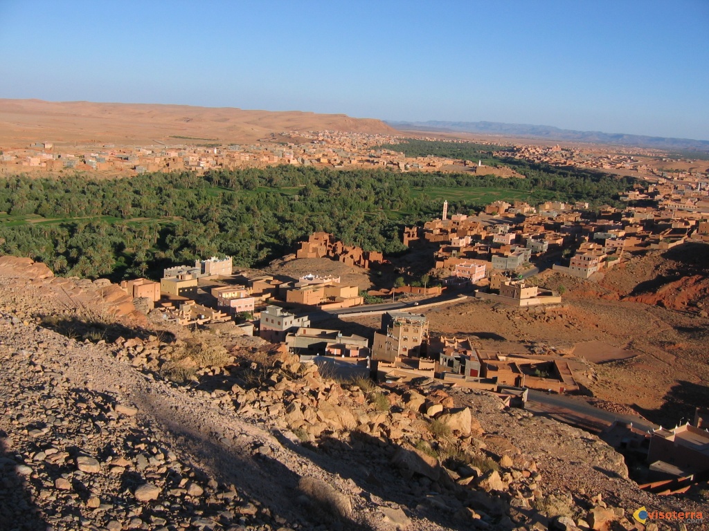
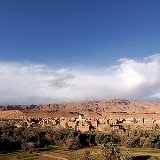
.jpg) Tinghir is a huge oasis stretching about 30 km long and varies in width from a few kilometers upstream and 4 km downstream. The climate of eastern Tinghir arid subtropical regions, ie hot, dries winters plus costs, in relation to altitude (1430 meters). There are a few rainy days per year, the largest precipitation occurring in fall and winter.
Tinghir is a huge oasis stretching about 30 km long and varies in width from a few kilometers upstream and 4 km downstream. The climate of eastern Tinghir arid subtropical regions, ie hot, dries winters plus costs, in relation to altitude (1430 meters). There are a few rainy days per year, the largest precipitation occurring in fall and winter.
Tinghir region is wedged between two mountain ranges, stretching over 700 km long, south-west to north-eastern Morocco: High Atlas
north climax over 4167m (Adrar Toubkal). Little Atlas to the south which is the Adrar Sarhro continuity. This is called path-South Atlas, which is also the road from Ouarzazate to Imtghren.
During the second era, this region has been periodically invaded by the sea, where thick deposits of sediments rich in marine fossils (ammonites are well represented). The uplift of the atlas, mainly during the Tertiary, causing the withdrawal of the sea and the deformation of the strata of rocks (folds, faults).
Wind erosion and river eventually shape the desert landscape of limestone and clay. Todgha the river has widened over time these layers of rock, which gave rise to impressive canyons 300m high but only 10m wide in some places.
Then the river widens and its banks to develop a green oasis (gardens, palm trees ...) edged radically with the colors red ocher of the desert stone.
Morocco
Morocco , officially the Kingdom of Morocco , is a country located in North Africa. It has a population of more than 32 million and an area of 710,850 km², and also primarily administers the disputed region of the Western Sahara...
, south of the High Atlas
High Atlas
High Atlas, also called the Grand Atlas Mountains is a mountain range in central Morocco in Northern Africa.The High Atlas rises in the west at the Atlantic Ocean and stretches in an eastern direction to the Moroccan-Algerian border. At the Atlantic and to the southwest the range drops abruptly...
and north of the Little Atlas, is part of the region of Ouarzazate
Ouarzazate
-See also:* Tizi n'Tichka: The mountain pass that leads to Ouarzazate* List of Movies shot in Morocco-External links:* at IMDb...
.
The name originally referred Tinghir the mountain "IGHIR" which meant the shoulder Tamazight, but it has gradually expanded to bring together all the villages around and give this name to the whole oasis.
Introduction
The city proper of Tinghir (Baladia tinghir) has 36,000 inhabitants, while the area as a whole has 86,500 inhabitants according to the 2004 census. Tinghir, in the region of Ouarzazate, is populated by Amazighs. Tinghir is at the center of one of the most beautiful oases of southern Morocco.This lush palm covers about 30 miles on 500 to 1500 m wide tracts along the Wadi Todgha. After the Todra Gorge
Todra Gorge
Todra Gorge is a canyon in the eastern part of the High Atlas Mountains in Morocco, near the town of Tinerhir. Both the Todra and neighbouring Dades Rivers have carved out cliff-sided canyons on their final through the mountains. The last of the Todra gorge are the most spectacular...
, Wadi Todgha is difficult to spawn a passage on the southern slopes of the great atlas (Tizgui), then leads into the great plain to meander slightly over twenty kilometers up Ferkla.
The palm Todgha, very dense and widespread, consists of only two sides of the ASSIF Todgha, it is irrigated by a network of pipes called tirgouine (plural of Târgu). Absorbed by a large number of irrigation canals, water from the ASSIF Todgha generally can not trickle up. Ferkla through his bed and then lay in the Ghris, but there are times when water during heavy floods, but it usually only lasts a few days.
Economy
The economy of the city relies mainly on agriculture, trade and services related to tourism. Many families are living on money sent home by their immigrant relatives in Europe.Social and cultural activities continue to grow strongly, in recent years projects for the entertainment of young children are increasing in many villages, and also literacy projects aimed at adults and particularly women are taking place. These projects are supported by a large number of local and foreign organisations (GTF, APS, and many others).
Natural geography
Tinghir region is wedged between two mountain ranges, stretching over 700 km long, south-west to north-eastern Morocco: High Atlas
High Atlas
High Atlas, also called the Grand Atlas Mountains is a mountain range in central Morocco in Northern Africa.The High Atlas rises in the west at the Atlantic Ocean and stretches in an eastern direction to the Moroccan-Algerian border. At the Atlantic and to the southwest the range drops abruptly...
north climax over 4167m (Adrar Toubkal). Little Atlas to the south which is the Adrar Sarhro continuity. This is called path-South Atlas, which is also the road from Ouarzazate to Imtghren.
During the second era, this region has been periodically invaded by the sea, where thick deposits of sediments rich in marine fossils (ammonites are well represented). The uplift of the atlas, mainly during the Tertiary, causing the withdrawal of the sea and the deformation of the strata of rocks (folds, faults).
Wind erosion and river eventually shape the desert landscape of limestone and clay. Todgha the river has widened over time these layers of rock, which gave rise to impressive canyons 300m high but only 10m wide in some places.
Then the river widens and its banks to develop a green oasis (gardens, palm trees ...) edged radically with the colors red ocher of the desert stone.