
Third Street Light Rail Project
Encyclopedia
>
|}
Muni Metro
Muni Metro is a light rail system serving San Francisco, California, operated by the San Francisco Municipal Railway , a division of the San Francisco Municipal Transportation Agency...
system in San Francisco, California along the eastern side of the city. Construction was finished near the end of 2006, and a weekend-only non-revenue service began on January 13, 2007. Full service started April 7, 2007. The new service, as the T Third Street Metro line, replaced most of the now defunct 15 Third bus line, running south from The Caltrain Depot
Caltrain
Caltrain is a California commuter rail line on the San Francisco Peninsula and in the Santa Clara Valley in the United States. The northern terminus of the rail line is in San Francisco, at 4th and King streets; its southern terminus is in Gilroy...
at 4th Street and King Street, along Third Street and Bayshore Boulevard to the Bayshore Caltrain Station in the Visitacion Valley
Visitacion Valley, San Francisco, California
Visitacion Valley is a neighborhood located in the south eastern quadrant of San Francisco, California.-Location:Visitacion Valley is roughly defined by McLaren Park and Gleneagles Golf Course to the West, Mansell Blvd to the North, Bayview Hill and Candlestick Cove to the East, and the San...
neighborhood.
The extension was supposed to connect directly to the Bayshore Caltrain Station when the station was in San Francisco County. However, as part of Caltrain's 2004 CTX project, Caltrain relocated the Bayshore Station to San Mateo County without informing Muni. To complicate matters, this connection has been plagued by cost and design issues. As a result, the initial line's terminus will be at the Sunnydale station on 3rd Street for the time being.
The T-line officially starts at St. Francis Circle
St. Francis Wood, San Francisco, California
St. Francis Wood is an affluent residential neighborhood located in southwestern San Francisco, California, south of the West Portal neighborhood and west of Mount Davidson....
light rail stop on West Portal Avenue
West Portal, San Francisco, California
West Portal is a small neighborhood in San Francisco, California. Like adjacent Forest Hill and St. Francis Wood, West Portal is an affluent, primarily residential area of the City...
, as it become a "T" line from its original "K" line and operates through the Market Street Tunnel
Market Street Tunnel
Market Street Tunnel refers to the following tunnels:*Market Street Tunnel , carrying rapid transit and light rail*Market Street Tunnel , carrying rapid transit and streetcars...
to the The Caltrain Depot
Caltrain
Caltrain is a California commuter rail line on the San Francisco Peninsula and in the Santa Clara Valley in the United States. The northern terminus of the rail line is in San Francisco, at 4th and King streets; its southern terminus is in Gilroy...
at Fourth Street and then along the new extension. The 15 Third bus line was eliminated and the 8X line was extended to replace the 15 in areas not served by the metro extension, including City College
City College of San Francisco
City College of San Francisco, or CCSF, is a two-year community college in San Francisco, California. The Ocean Avenue campus, in the Ingleside neighborhood, is the college's primary location...
and Fisherman's Wharf
Fisherman's Wharf, San Francisco, California
Fisherman's Wharf is a neighborhood and popular tourist attraction in San Francisco, California. It roughly encompasses the northern waterfront area of San Francisco from Ghirardelli Square or Van Ness Avenue east to Pier 35 or Kearny Street...
.
The project was initially budgeted at $667 million. As of July 2006, the budget increased by $120 million.
The Third Street Light Rail Project is the first part of a two-phase plan to expand the Muni Metro system. The second phase, known as the Central Subway
Central Subway
The Central Subway is an extension of the Muni Metro light rail system in San Francisco, California, from the Caltrain commuter rail depot at 4th and King streets to Chinatown. The subway is the second phase of the Third Street Light Rail Project...
project, has a planned underground extension that would run north from The Caltrain Depot
Caltrain
Caltrain is a California commuter rail line on the San Francisco Peninsula and in the Santa Clara Valley in the United States. The northern terminus of the rail line is in San Francisco, at 4th and King streets; its southern terminus is in Gilroy...
at 4th And King Sts.
San Francisco 4th and King Street Station
San Francisco 4th and King Street or 4th and King station or Caltrain Depot is the northern terminus of the Caltrain commuter rail line that serves San Francisco Peninsula and Santa Clara Valley, and is a major regional transit hub...
passing The Moscone Convention and Exhibition Center
Moscone Center
Moscone Center is the largest convention and exhibition complex in San Francisco, California. It comprises three main halls: Two underground halls underneath Yerba Buena Gardens, known as Moscone North and Moscone South, and a three-level Moscone West exhibition hall across 4th Street...
, going under Market Street, a stop at Union Square and ending on Stockton and Washington Streets in Chinatown.
In the early part of March 2009, media and community groups proposed that, as the Central Subway
Central Subway
The Central Subway is an extension of the Muni Metro light rail system in San Francisco, California, from the Caltrain commuter rail depot at 4th and King streets to Chinatown. The subway is the second phase of the Third Street Light Rail Project...
is being built, plans should be drawn up for the eventual extension of the T-line through North Beach and Fisherman's Wharf
Fisherman's Wharf, San Francisco, California
Fisherman's Wharf is a neighborhood and popular tourist attraction in San Francisco, California. It roughly encompasses the northern waterfront area of San Francisco from Ghirardelli Square or Van Ness Avenue east to Pier 35 or Kearny Street...
neighborhoods, passing Pier 39
Pier 39
Pier 39 is a shopping center and popular tourist attraction built on a pier in San Francisco, California. At Pier 39, there are shops, restaurants, a video arcade, street performances, an interpretive center for the Marine Mammal Center, the Aquarium of the Bay, virtual 3D rides, and views of...
, using an old coal railroad line underneath Fort Mason
Fort Mason
Fort Mason, once known as San Francisco Port of Embarkation, US Army, in San Francisco, California, is a former United States Army post located in the northern Marina District, alongside San Francisco Bay. Fort Mason served as an Army post for more than 100 years, initially as a coastal defense...
and ending up at The Presidio
Presidio of San Francisco
The Presidio of San Francisco is a park on the northern tip of the San Francisco Peninsula in San Francisco, California, within the Golden Gate National Recreation Area...
.
Features
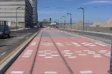
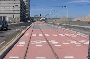
As part of the project, the entire Third Street corridor was repaved and received new streetlights. Additionally, trees were planted, sidewalks reconstructed and the pavement on 3rd Street repaved. Stations along the route have a distinctive marquee pole with a sculpture or mobile.Light rail vehicles (LRVs) operate in an exclusive right-of-way
Right-of-way (railroad)
A right-of-way is a strip of land that is granted, through an easement or other mechanism, for transportation purposes, such as for a trail, driveway, rail line or highway. A right-of-way is reserved for the purposes of maintenance or expansion of existing services with the right-of-way...
in the center of the street, except in the Bayview business district, to bypass vehicular congestion and increase speed along the line. LRV's will operate in mixed flow with other cars at the 4th Street Bridge and in a 10 block segment in the Bayview Area. The 4th Street bridge did not have enough room for an exclusive right-of-way. In the Bayview business district, parking was maintained on both sides of the street for customers of local merchants.
In addition, transit signal priority has been implemented along the entire corridor. The goal is to allow LRVs to have a green light at every intersection so they can travel from station to station without stopping.
Stations
19 new stations were built along the line. They consist of high platforms either built between the tracks or with one on each side, similar to the ones used by the N Judah along the Embarcadero. The stations are:- Fourth Street & King Street (Separate from the existing station at Fourth & King)
- Third Street & Mission Rock Street
- Third Street & South Street / UCSF-Gene Friend Way
- Third Street & Mariposa Street
- Third Street & 20th Street
- Third Street & 23rd Street
- Third Street & Marin Street
- Third Street & Evans Street
- Third Street & Hudson Avenue
- Third Street & Kirkwood Avenue
- Third Street & Palou Avenue
- Third Street & Thomas Avenue
- Third Street & Van Dyke Avenue
- Third Street & Carroll Avenue
- Third Street & Gilman Avenue
- Third Street & Leconte Avenue
- Bayshore Boulevard & Arleta Avenue
- Bayshore Boulevard & Sunnydale Avenue
- CaltrainCaltrainCaltrain is a California commuter rail line on the San Francisco Peninsula and in the Santa Clara Valley in the United States. The northern terminus of the rail line is in San Francisco, at 4th and King streets; its southern terminus is in Gilroy...
Bayshore Station (future extension)
External links
- ON REGIONAL TRANSIT Going underground in Chinatown. Gerald Cauthen, San Francisco Chronicle April 7, 2008.
- Everyone has an idea on S.F. subway plan. C.W. Nevius, San Francisco Chronicle, September 13, 2008.
- Overview: The Project in a Nutshell. SFMuni.com.
- Map of the extension. SFMuni.com.
- Central Subway Overview. SFMTA.com.
- $147 Million Deal Could Derail Central Subway Project Budget. Chuck Finnie, SFAppeal.com, March 9, 2009.
- Central Subway may travel farther north than planned. SF Examiner.