
Thiel Mountains
Encyclopedia
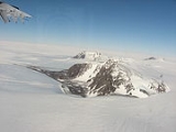
The Thiel Mountains are an isolated, mainly snow-capped mountain range
in Antarctica which are 72 km (45 mi) long. The mountains are located roughly between the Horlick Mountains
and the Pensacola Mountains
, and extend from Moulton Escarpment on the west to Nolan Pillar on the east. Major components include Ford Massif (2,810 m), Bermel Escarpment and a group of eastern peaks near Nolan Pillar. The mountains were observed and first positioned by the USARP
Horlick Mountains Traverse Party, 1958-59. The mountains were surveyed by the USGS Thiel Mountains parties of 1960-61 and 1961-62.
The Thiel Mountains were named by US-ACAN
after Edward C. Thiel, traverse seismologist at Ellsworth Station
and the Pensacola Mountains in 1957. In December 1959, he made airlifted geophysical observations along the 88th meridian west
, including work near these mountains. Thiel perished with four others on November 9, 1961 in the crash of a P2V Neptune aircraft soon after take-off from Wilkes Station
.
An aircraft fuel cache (85°12′S 087°53′W) is located near the Thiel Mountains for planes traveling between Patriot Hills
and the Amundsen-Scott South Pole Station
.
Mountain range
A mountain range is a single, large mass consisting of a succession of mountains or narrowly spaced mountain ridges, with or without peaks, closely related in position, direction, formation, and age; a component part of a mountain system or of a mountain chain...
in Antarctica which are 72 km (45 mi) long. The mountains are located roughly between the Horlick Mountains
Horlick Mountains
The Horlick Mountains are a mountain range in the Transantarctic Mountains of Antarctica, lying eastward of Reedy Glacier and including the Wisconsin Range, Long Hills and Ohio Range....
and the Pensacola Mountains
Pensacola Mountains
The Pensacola Mountains are a large group of mountain ranges and peaks in Antarctica, extending 450 km in a NE-SW direction, comprising the Argentina Range, Forrestal Range, Dufek Massif, Cordiner Peaks, Neptune Range, Patuxent Range, Rambo Nunataks and Pecora Escarpment...
, and extend from Moulton Escarpment on the west to Nolan Pillar on the east. Major components include Ford Massif (2,810 m), Bermel Escarpment and a group of eastern peaks near Nolan Pillar. The mountains were observed and first positioned by the USARP
United States Antarctic Program
United States Antarctic Program is an organization of the United States government which has presence in the continent of Antarctica. It co-ordinates research and the operational support for research in the region...
Horlick Mountains Traverse Party, 1958-59. The mountains were surveyed by the USGS Thiel Mountains parties of 1960-61 and 1961-62.
The Thiel Mountains were named by US-ACAN
Advisory Committee on Antarctic Names
The Advisory Committee on Antarctic Names is an advisory committee of the United States Board on Geographic Names responsible for recommending names for features in Antarctica...
after Edward C. Thiel, traverse seismologist at Ellsworth Station
Ellsworth Station
The Ellsworth Station was an Antarctic base established by the United States during the 1957 International Geophysical Year. The base was soon handed over to Argentina and subsequently abandoned and covered with ice in 1962.-History:...
and the Pensacola Mountains in 1957. In December 1959, he made airlifted geophysical observations along the 88th meridian west
88th meridian west
The meridian 88° west of Greenwich is a line of longitude that extends from the North Pole across the Arctic Ocean, North America, the Gulf of Mexico, the Caribbean Sea, Central America, the Pacific Ocean, the Southern Ocean, and Antarctica to the South Pole....
, including work near these mountains. Thiel perished with four others on November 9, 1961 in the crash of a P2V Neptune aircraft soon after take-off from Wilkes Station
Wilkes Station
Wilkes Station was an Antarctic research station established 29 January 1957 by the United States as one of seven U.S. stations established for the International Geophysical Year program in Antarctica...
.
An aircraft fuel cache (85°12′S 087°53′W) is located near the Thiel Mountains for planes traveling between Patriot Hills
Patriot Hills
Patriot Hills was the only private seasonally occupied camp in Antarctica. It was located in the Heritage Range of the Ellsworth Mountains, next to a group of hills that gives it its name...
and the Amundsen-Scott South Pole Station
Amundsen-Scott South Pole Station
The Amundsen–Scott South Pole Station is the American scientific research station on the high plateau of Antarctica. This station is located at the southernmost place on the Earth, the Geographic South Pole, at an elevation of 2,835 meters above sea level.The original Amundsen-Scott Station was...
.