
Tennessee State Route 99
Encyclopedia
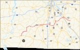
State Route 99 is a long east–west highway in Middle Tennessee
. The route travels through large sections of rural areas and for most of the length is a secondary highway. The route begins near Waynesboro
and ends in Bradyville after logging 128.4 mi (206.6 km) and passing through six counties.
The highway begins at an intersection with U.S. Route 64
as a secondary route that was the former route of US 64 in Wayne County
. From there it travels through Lewis County where it meets U.S. Route 412
. At this point SR-99 is concurrent with US 412 though it is not signed. This remains until US 412 and SR-99 enters Maury County. East of Columbia
, SR-99 separates from US 412 at Interstate 65
as US 412 ends. From here SR-99 crosses into Marshall County before entering Rutherford County
. In Murfreesboro
, SR-99 is unsigned from the intersection with SR-96
to US 70S
and US 41
. Then SR-99 heads into Cannon County to its terminus.
Middle Tennessee
Middle Tennessee is a distinct portion of the state of Tennessee, delineated according to state law as the 41 counties in the Middle Grand Division of Tennessee....
. The route travels through large sections of rural areas and for most of the length is a secondary highway. The route begins near Waynesboro
Waynesboro, Tennessee
Waynesboro is a city in and the county seat of Wayne County, Tennessee, United States. The population was 2,449 at the 2010 census.-Geography:Waynesboro is located at ....
and ends in Bradyville after logging 128.4 mi (206.6 km) and passing through six counties.
The highway begins at an intersection with U.S. Route 64
U.S. Route 64
U.S. Route 64 is an east–west United States highway that runs for 2,326 miles from eastern North Carolina to just southwest of the Four Corners in northeast Arizona. The western terminus is at U.S. Route 160 in Teec Nos Pos, Arizona. The highway's eastern terminus is at NC 12 and U.S. Route...
as a secondary route that was the former route of US 64 in Wayne County
Wayne County, Tennessee
As of the census of 2010, there were 17,021 people, 5,822 households, and 4,321 families residing in the county. The population density was 23 people per square mile . There were 6,701 housing units at an average density of 9 per square mile...
. From there it travels through Lewis County where it meets U.S. Route 412
U.S. Route 412
U.S. Route 412 is an east–west United States highway, first commissioned in 1982. Its route number is a "violation" of the usual AASHTO numbering scheme, as it comes nowhere near its implied "parent", US 12. U.S...
. At this point SR-99 is concurrent with US 412 though it is not signed. This remains until US 412 and SR-99 enters Maury County. East of Columbia
Columbia, Tennessee
Columbia is a city in Maury County, Tennessee, United States. The 2008 population was 34,402 according to U.S. Census Bureau estimates. It is the county seat of Maury County....
, SR-99 separates from US 412 at Interstate 65
Interstate 65 in Tennessee
Interstate 65 in Tennessee runs from Ardmore, Tennessee north to just south of Franklin, Kentucky, forming part of the national Interstate 65, which goes from Mobile, Alabama to Gary, Indiana. In Tennessee the highway's official name is The Albert Arnold Gore Sr...
as US 412 ends. From here SR-99 crosses into Marshall County before entering Rutherford County
Rutherford County, Tennessee
Rutherford County is a county located in the U.S. state of Tennessee. As of the 2010 census, it is the state's fifth-largest county by population with 262,604 people, an increase of 44.3 percent over the 2000 population of 182,023. Its county seat is Murfreesboro, which is also the geographic...
. In Murfreesboro
Murfreesboro, Tennessee
Murfreesboro is a city in and the county seat of Rutherford County, Tennessee, United States. The population was 108,755 according to the United States Census Bureau's 2010 U.S. Census, up from 68,816 residents certified during the 2000 census. The center of population of Tennessee is located in...
, SR-99 is unsigned from the intersection with SR-96
Tennessee State Route 96
State Route 96 is a long east–west highway in Middle Tennessee. The road begins in Dickson and ends in Granville. The current length is . Along its path it goes through 10 counties. Locals mostly refer to it as Highway 96.- Route description :...
to US 70S
U.S. Route 70
U.S. Route 70 is an east–west United States highway that runs for 2,385 miles from eastern North Carolina to east-central Arizona. As can be derived from its number, it is a major east–west highway of the Southern and Southwestern United States...
and US 41
U.S. Route 41
U.S. Route 41 is a north–south United States Highway that runs from Miami, Florida to the Upper Peninsula of Michigan. Until 1949, the part in southern Florida, from Naples to Miami, was U.S...
. Then SR-99 heads into Cannon County to its terminus.
Length
| county | mi | km |
| Wayne Wayne County, Tennessee As of the census of 2010, there were 17,021 people, 5,822 households, and 4,321 families residing in the county. The population density was 23 people per square mile . There were 6,701 housing units at an average density of 9 per square mile... |
14.1 | 22.7 |
| Lewis | 30 | 48.3 |
| Maury | 31.6 | 50.9 |
| Marshall | 14.7 | 23.7 |
| Rutherford Rutherford County, Tennessee Rutherford County is a county located in the U.S. state of Tennessee. As of the 2010 census, it is the state's fifth-largest county by population with 262,604 people, an increase of 44.3 percent over the 2000 population of 182,023. Its county seat is Murfreesboro, which is also the geographic... |
36.6 | 58.9 |
| Cannon | 1.4 | 2.3 |
| Total | 128.4 | 206.6 |
Major intersections
| County | Location | Mile | Intersects | Notes |
|---|---|---|---|---|
 begins as a secondary route begins as a secondary route |
||||
| Wayne Wayne County, Tennessee As of the census of 2010, there were 17,021 people, 5,822 households, and 4,321 families residing in the county. The population density was 23 people per square mile . There were 6,701 housing units at an average density of 9 per square mile... |
Waynesboro Waynesboro, Tennessee Waynesboro is a city in and the county seat of Wayne County, Tennessee, United States. The population was 2,449 at the 2010 census.-Geography:Waynesboro is located at .... |
0.0 | (Dexter L. Woods Memorial Boulevard) | |
| Lewis | Hohenwald Hohenwald, Tennessee Hohenwald is a city in and the county seat of Lewis County, Tennessee, United States. The population was 3,754 at the 2000 census. The name "Hohenwald" is a German word that means "High Forest". The town was founded in 1878 and later merged with a town named "New Switzerland" to the south. New... |
|||
| 28.5 | SR-20 concurrent for 0.7 mi (1.1 km) | |||
| 28.8 | (South Park Street) | SR-48 concurrent with SR-99 and SR-20 for 0.4 mi (0.643736 km) | ||
| 29.2 | (Main Street) | concurrency with SR-48 and SR-20 end | ||
concurrent for 41.8 mi (67.3 km) and primary route  is unsigned is unsignedUnsigned highway An unsigned highway is a highway that has been assigned a route number, but does not bear conventional road markings that would normally be used to identify the route with that number... |
||||
| 37.4 | Natchez Trace Parkway The Natchez Trace Parkway is a National Park Service unit in the southeastern United States that commemorates the historic Old Natchez Trace and preserves sections of the original trail.... |
|||
| Maury | 47.0 | |||
| Columbia Columbia, Tennessee Columbia is a city in Maury County, Tennessee, United States. The 2008 population was 34,402 according to U.S. Census Bureau estimates. It is the county seat of Maury County.... |
||||
| 57.2 | (Columbia Bypass) | SR-99 continues into downtown Columbia concurrent with US 412 BUS | ||
| 59.3 | SR-50 concurrent with SR-99 and US 412 BUS for 1.1 mi (1.8 km) | |||
| 60.4 | concurrency with SR-50 ends (US 412 BUS still concurrent) | |||
| 61.4 | ||||
| 62.0 | (North Garden Street) | US 31 concurrent for 1.9 mi (3.1 km) and SR-7 concurrent for 0.5 mi (0.80467 km) | ||
| 62.5 | concurrency with SR-7 ends and concurrency with US 31 and US 412 BUS continues | |||
| 63.9 | (Bear Creek Pike) | US 412 BUS ends and SR-99 rejoins concurrency with main US 412 route/US 31 concurreny ends | ||
| 71.0 | ||||
| eastern national terminus of , SR-99 signage reusmes | ||||
| 74.9 | (Lewisburg Lewisburg, Tennessee Lewisburg is a city in Marshall County, Tennessee, United States. The population was 10,413 at the 2000 census. It is the county seat of Marshall County... and Franklin Franklin, Tennessee Franklin is a city within and the county seat of Williamson County, Tennessee, United States. The population was 62,487 as of the 2010 census Franklin is located approximately south of downtown Nashville.-History:... Pike) |
US 431 and SR-106 concurrent for 0.8 mi (1.3 km) | ||
| 75.7 | (Lewisburg Lewisburg, Tennessee Lewisburg is a city in Marshall County, Tennessee, United States. The population was 10,413 at the 2000 census. It is the county seat of Marshall County... and Franklin Franklin, Tennessee Franklin is a city within and the county seat of Williamson County, Tennessee, United States. The population was 62,487 as of the 2010 census Franklin is located approximately south of downtown Nashville.-History:... Pike) |
US 431 and SR-106 concurrency ends | ||
| Marshall | ||||
| 79.5 | ||||
| Chapel Hill Chapel Hill, Tennessee Chapel Hill is a town in the northeastern part of Marshall County, Tennessee, United States. The town was named after Chapel Hill, North Carolina by settlers from that area... |
||||
| 83.1 | (Sam Davis Sam Davis Sam Davis is called the Boy Hero of the Confederacy. He was born in Rutherford County, Tennessee. He served in various combat roles in the Confederate army in 1861 through 1863 during the American Civil War... Highway) |
US 31A and SR-11 concurrent for 3.3 mi (5.3 km) | ||
| reverts to a secondary route |
||||
| 83.9 | ||||
| 86.4 | (Nashville Nashville, Tennessee Nashville is the capital of the U.S. state of Tennessee and the county seat of Davidson County. It is located on the Cumberland River in Davidson County, in the north-central part of the state. The city is a center for the health care, publishing, banking and transportation industries, and is home... Highway) |
US 31A and SR-11 concurrency ends | ||
| Rutherford Rutherford County, Tennessee Rutherford County is a county located in the U.S. state of Tennessee. As of the 2010 census, it is the state's fifth-largest county by population with 262,604 people, an increase of 44.3 percent over the 2000 population of 182,023. Its county seat is Murfreesboro, which is also the geographic... |
Eagleville Eagleville, Tennessee Eagleville is a city in Rutherford County, Tennessee, United States. The population was 464 at the 2000 census.-Geography:Eagleville is located at .... |
|||
| 92.9 | (South Main Street) | US 41A and SR-16 concurrent for 1.5 mi (2.4 km) | ||
| 94.4 | US 41A and SR-16 concurrency ends and SR-269 concurrent for 5.5 mi (8.9 km) | |||
| 99.9 | SR-269 concurrency ends | |||
| Murfreesboro Murfreesboro, Tennessee Murfreesboro is a city in and the county seat of Rutherford County, Tennessee, United States. The population was 108,755 according to the United States Census Bureau's 2010 U.S. Census, up from 68,816 residents certified during the 2000 census. The center of population of Tennessee is located in... |
||||
| 110.3 | ||||
| 111.6 | SR-96 concurrent for 0.6 mi (0.965604 km) and SR-99 is unsigned Unsigned highway An unsigned highway is a highway that has been assigned a route number, but does not bear conventional road markings that would normally be used to identify the route with that number... |
|||
| 112.2 |      US 70S US 70SU.S. Route 70S U.S. Route 70s is an alternate to U.S. Route 70 between the western part of Nashville, TN and Sparta, Tennessee. It runs concurrent with US 70 for several blocks in downtown Nashville... /US 41 U.S. Route 41 U.S. Route 41 is a north–south United States Highway that runs from Miami, Florida to the Upper Peninsula of Michigan. Until 1949, the part in southern Florida, from Naples to Miami, was U.S... /US 231 U.S. Route 231 U.S. Route 231 is a parallel route of U.S. Route 31. It currently runs for 912 miles from St. John, Indiana, at U.S. Route 41 to south of U.S. Route 98 in Downtown Panama City, Florida.One of its most notable landmarks is the William H... /SR-1(unsigned Unsigned highway An unsigned highway is a highway that has been assigned a route number, but does not bear conventional road markings that would normally be used to identify the route with that number... )/SR-10 Tennessee State Route 10 State Route 10 is a south–north route from the Alabama state line in Lincoln County, Tennessee to the Kentucky state line in Macon County- Route description :... (unsigned Unsigned highway An unsigned highway is a highway that has been assigned a route number, but does not bear conventional road markings that would normally be used to identify the route with that number... ) (NW Broad Street) |
US 70S and SR-1 concurrent for 1.2 mi (1.9 km), US 41 concurrent for 1.3 mi (2.1 km), US 231 and SR-10 concurrent for 0.7 mi (1.1 km), SR-96 concurrency ends | ||
| 112.9 | (South Church Street) | US 231 and SR-10 concurrency ends, US 70S, US 41, and SR-1 concurrency continues | ||
| 113.4 | (Mercury Boulevard) | US 70S and SR-1 concurrency ends, US 41 concurrency continues, and SR-2 concurrent for 0.1 mi (0.160934 km) | ||
| 113.5 | (SE Broad Street) | US 41 and SR-2 concurrency ends | ||
| Cannon | Bradyville | 128.4 | ||
| ends as a secondary route |
||||