
Temple Basin
Encyclopedia
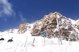
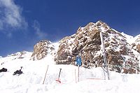
Temple Basin is a club skifield
in Arthur's Pass
, in New Zealand
's South Island
. Operated by two clubs, the Temple Basin Ski Club, and the Canterbury University Snow Sports Club, the ski area has 3 rope tows, two on-site lodges, a ski school and ski shop. The tows cover an elevation range of 1326-1753 metres, for a skiable domain of 320 hectare
s. Its natural terrain has been highly recommended by adventure skiers on several occasions.
Temple Basin is home to the New Zealand Snow Safety Institute. The New Zealand Snow Safety Institute runs a series of courses throughout the year on aspects of mountaineering and mountain safety. These courses are aimed for climbers, skiers, snowboarders and trampers. The lodges at Temple Basin allows for students to stay on field and watch the snow pack evolve over time aiding the learning of these skills.
 Temple Basin is approximately 2 hours from Christchurch
by car, followed by a 45 minute walk. Like many club fields, a good portion of the skiable area is accessible only by hiking, including some hiking between lifts.
The field consists of 4 main basins. Cassidy Tow accesses a smooth open basin with beginner and intermediate terrain. Temple Tow accesses an intermediate slope. Between Cassidy and Temple tows a stream gut offers rock faces and snow traps. A short walk from the top of Temple Tow brings users to Downhill Basin and the fields highest Tow. Downhill consists of a wide open bowl with Blimit and Mt Temples peaks above. A traverse and hike from the top of temple tow gives users access to Bills Basin, an intermediate basin with a collection of shoots at the bottom. From the top of Downhill tow one can also hike to the peak accessing the Mingha Valley over the ridge. The Mingha, whilst not patrolled, is commonly used by backcountry skiers and snowboarders.
This field is just on the Western side of the Southern Alps
and so receives significantly more snowstorms than those areas further east.
Club skifield
In New Zealand, a club skifield is a small ski resort run by a ski club to provide affordable skiing to its members. While members of the public can ski, members of the club receive heavily discounted rates, in exchange for a yearly membership fee and usually several days of voluntary work...
in Arthur's Pass
Arthur's Pass
Arthur's Pass is a mountain pass in the Southern Alps of the South Island of New Zealand. It marks part of the boundary between the West Coast and Canterbury regions, 140 km from Christchurch and 95 km from Greymouth. The pass lies in a saddle between the valleys of the Otira River, a...
, in New Zealand
New Zealand
New Zealand is an island country in the south-western Pacific Ocean comprising two main landmasses and numerous smaller islands. The country is situated some east of Australia across the Tasman Sea, and roughly south of the Pacific island nations of New Caledonia, Fiji, and Tonga...
's South Island
South Island
The South Island is the larger of the two major islands of New Zealand, the other being the more populous North Island. It is bordered to the north by Cook Strait, to the west by the Tasman Sea, to the south and east by the Pacific Ocean...
. Operated by two clubs, the Temple Basin Ski Club, and the Canterbury University Snow Sports Club, the ski area has 3 rope tows, two on-site lodges, a ski school and ski shop. The tows cover an elevation range of 1326-1753 metres, for a skiable domain of 320 hectare
Hectare
The hectare is a metric unit of area defined as 10,000 square metres , and primarily used in the measurement of land. In 1795, when the metric system was introduced, the are was defined as being 100 square metres and the hectare was thus 100 ares or 1/100 km2...
s. Its natural terrain has been highly recommended by adventure skiers on several occasions.
Temple Basin is home to the New Zealand Snow Safety Institute. The New Zealand Snow Safety Institute runs a series of courses throughout the year on aspects of mountaineering and mountain safety. These courses are aimed for climbers, skiers, snowboarders and trampers. The lodges at Temple Basin allows for students to stay on field and watch the snow pack evolve over time aiding the learning of these skills.
Christchurch
Christchurch is the largest city in the South Island of New Zealand, and the country's second-largest urban area after Auckland. It lies one third of the way down the South Island's east coast, just north of Banks Peninsula which itself, since 2006, lies within the formal limits of...
by car, followed by a 45 minute walk. Like many club fields, a good portion of the skiable area is accessible only by hiking, including some hiking between lifts.
The field consists of 4 main basins. Cassidy Tow accesses a smooth open basin with beginner and intermediate terrain. Temple Tow accesses an intermediate slope. Between Cassidy and Temple tows a stream gut offers rock faces and snow traps. A short walk from the top of Temple Tow brings users to Downhill Basin and the fields highest Tow. Downhill consists of a wide open bowl with Blimit and Mt Temples peaks above. A traverse and hike from the top of temple tow gives users access to Bills Basin, an intermediate basin with a collection of shoots at the bottom. From the top of Downhill tow one can also hike to the peak accessing the Mingha Valley over the ridge. The Mingha, whilst not patrolled, is commonly used by backcountry skiers and snowboarders.
This field is just on the Western side of the Southern Alps
Southern Alps
The Southern Alps is a mountain range extending along much of the length of New Zealand's South Island, reaching its greatest elevations near the island's western side...
and so receives significantly more snowstorms than those areas further east.