

Sørkapp Land
Encyclopedia
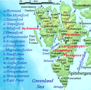
Hornsund
Hornsund is a fjord on the western side of the southernmost tip of Spitsbergen island.The fjord's mouth faces west to the Greenland Sea, and is 12 km wide. The length is 30 kilometres, the mean depth is 90 metres, and the maximal depth is 260 metres...
, at the southern part of Spitsbergen
Spitsbergen
Spitsbergen is the largest and only permanently populated island of the Svalbard archipelago in Norway. Constituting the western-most bulk of the archipelago, it borders the Arctic Ocean, the Norwegian Sea and the Greenland Sea...
, Svalbard
Svalbard
Svalbard is an archipelago in the Arctic, constituting the northernmost part of Norway. It is located north of mainland Europe, midway between mainland Norway and the North Pole. The group of islands range from 74° to 81° north latitude , and from 10° to 35° east longitude. Spitsbergen is the...
. The glaciers Hornbreen and Hambergbreen divide Sørkapp Land from the Torell Land
Torell Land
Torell Land is a land area at the southeast part of Spitsbergen, Svalbard. It is named after Otto Martin Torell. The glaciers Hornbreen and Hambergbreen divide Torell Land from Sørkapp Land.Torell Land is included in the Sør-Spitsbergen National Park....
.
Sørkapp Land is included in the Sør-Spitsbergen National Park
Sør-Spitsbergen National Park
Sør-Spitsbergen National Park lies on south end of Spitsbergen island in the Svalbard archipelago, Norway. The park was opened in 1973 and includes Wedel Jarlsberg Land, Torell Land and Sørkapp Land. Over 65% of the region is covered with glacier or permanent ice and snow.-References:...
.