

São João Batista do Glória
Encyclopedia
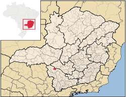
Minas Gerais
Minas Gerais is one of the 26 states of Brazil, of which it is the second most populous, the third richest, and the fourth largest in area. Minas Gerais is the Brazilian state with the largest number of Presidents of Brazil, the current one, Dilma Rousseff, being one of them. The capital is the...
. Its population as of 2007 was 6,828 people living in a total area of 553 km². The city belongs to the meso-region of Sul e Sudoeste de Minas and to the micro-region of Passos
Passos, Minas Gerais
Passos is a Brazilian municipality located in the southwest of the state of Minas Gerais. Its population as of 2007 was 122,765 people living in a total area of 1,339 km². The city belongs to the meso-region of Sul e Sudoeste de Minas and to the micro-region of Passos...
. It became a municipality in 1948.
Location
The city center of São João Batista do Glória is located at an elevation of 695 meters in the valley of the Rio Grande, a short distance northeast of regional center, PassosPassos
-People:* Cristiano Ávalos dos Passos* John Dos Passos* Márcio Emerson Passos de Albuquerque, a Brazilian footballer* Rosa Passos* Vítor Hugo Gomes Passos, a Portuguese footballer-Brazil:* Passos, Minas Gerais, a municipality in the State of Minas Gerais...
. Neighboring municipalities are: Vargem Bonita
Vargem Bonita
Vargem Bonita is a Brazilian municipality located in the west of the state of Minas Gerais. Its population as of 2007 was 2,098 people living in a total area of 409 km². The city belongs to the meso-region of Oeste de Minas and to the micro-region of Piumhi...
(77 km north), Capitólio
Capitólio
Capitólio is a Brazilian municipality located in the southwest of the state of Minas Gerais. Its population as of 2007 was 7,634 people living in a total area of 522 km². The city belongs to the meso-region of Sul e Sudoeste de Minas and to the micro-region of Passos...
(65 km east), São José da Barra
São José da Barra
São José da Barra is a Brazilian municipality located in the southwest of the state of Minas Gerais. Its population as of 2007 was 6,701 people living in a total area of 312 km². The city belongs to the meso-region of Sul e Sudoeste de Minas and to the micro-region of Passos. It became a...
(40 km southeast), Alpinópolis
Alpinópolis
Alpinópolis is a Brazilian municipality located in the southwest of the state of Minas Gerais. As of 2007, its population was 17,821 people and its area was of 458 km². The city is located in the Southwestern region of Minas Gerais and the micro-region of Passos. It became a municipality in 1938...
(33 km south), Passos
Passos
-People:* Cristiano Ávalos dos Passos* John Dos Passos* Márcio Emerson Passos de Albuquerque, a Brazilian footballer* Rosa Passos* Vítor Hugo Gomes Passos, a Portuguese footballer-Brazil:* Passos, Minas Gerais, a municipality in the State of Minas Gerais...
(14 km south and southwest), Delfinópolis
Delfinópolis
Delfinópolis is a Brazilian municipality located in the southwest of the state of Minas Gerais. Its population as of 2007 was 6,698 people living in a total area of 1,375 km². The city belongs to the meso-region of Sul e Sudoeste de Minas and to the micro-region of Passos...
(70 km west). The terrain is hilly and there are many waterfalls in the streams. In the higher elevations there are still armadillos, guará wolves, emas
EMAS
EMAS may be:* EMAS , a global offshore contractor and provider of integrated offshore solutions to the oil and gas industry and operating brand for Ezra Holdings....
, and toucans.
Distances
- Belo HorizonteBelo HorizonteBelo Horizonte is the capital of and largest city in the state of Minas Gerais, located in the southeastern region of Brazil. It is the third largest metropolitan area in the country...
: 324 km - BrasíliaBrasíliaBrasília is the capital city of Brazil. The name is commonly spelled Brasilia in English. The city and its District are located in the Central-West region of the country, along a plateau known as Planalto Central. It has a population of about 2,557,000 as of the 2008 IBGE estimate, making it the...
- 800 km - FrancaFranca-Demography:*Total: 328.473 inhabitants on July 1, 2006.** Urban: 324.138** Rural: 6.999*Demographic density : 473,80*Child mortality until 1 year : 12,66 = 1,26%*Life expectancy : 73,03*Fertility : 2,26...
: 130 km - UberabaUberabaUberaba is a city and municipality in the west of the state of Minas Gerais in Brazil. Its population is 296.000 with an area of 4529.7 km², giving a density of 60.71 people per km². It is located on a plateau at an elevation of 785 meters and is in the Uberaba River floodplain...
: 230 km - Ribeirão PretoRibeirão PretoRibeirão Preto is a municipality and city in the Northeastern region of the state of São Paulo in Brazil. It is nicknamed Brazilian California, because of a combination of an economy based on agrobusiness plus high technology, wealth and sunny weather all year long. With 605,114 inhabitants,...
: 180 km - CampinasCampinasCampinas is a city and municipality located in the coastal interior of the state of São Paulo, Brazil. is the administrative center of the meso-region of the same name, with 3,783,597 inhabitants as of the 2010 Census, consisting of 49 cities....
: 315 km - PassosPassos-People:* Cristiano Ávalos dos Passos* John Dos Passos* Márcio Emerson Passos de Albuquerque, a Brazilian footballer* Rosa Passos* Vítor Hugo Gomes Passos, a Portuguese footballer-Brazil:* Passos, Minas Gerais, a municipality in the State of Minas Gerais...
: 14 km on MG-146 - Furnas Dam: 18 km
Economic Activities
Services, industries, and agriculture are the main economic activities. There are brickworks and factories producing spirits. The GDP in 2005 was approximately R$449 million, with 82 million reais from taxes, 37 million reais from services, 301 million reais from industry, and 32 million reais from agriculture. The biggest employer was public administration with 410 workers in 2005. In the rural area there were 236 producers on 26,000 hectares of land. Approximately 600 persons were occupied in agriculture. The main crops are coffee, beans, and corn. There were 25,000 head of cattle, of which 9,000 were milk cows (2006).There were no banks (2007). In the vehicle fleet there were 787 automobiles, 69 trucks, 66 pickup trucks, 10 buses, and 663 motorcycles (2007).
Health and Education
In the health sector there were 5 health clinics and 1 hospital with 25 beds (2005). Educational needs of 1,550 students were attended to by 3 primary schools, 1 middle school, and 1 pre-primary school.- Municipal Human Development IndexHuman Development IndexThe Human Development Index is a composite statistic used to rank countries by level of "human development" and separate "very high human development", "high human development", "medium human development", and "low human development" countries...
: 0.770 (2000) - State ranking: 165 out of 853 municipalities as of 2000
- National ranking: 1321 out of 5,138 municipalities as of 2000
- Literacy rate: 86%
- Life expectancy: 73 (average of males and females)
In 2000 the per capita monthly income of R$240.00 was below the state average of R$276.00 and below the national average of R$297.00. Poços de Caldas
Poços de Caldas
Poços de Caldas is a city and municipality in south-western Minas Gerais state, Brazil, in the microregion of the same name. Its estimated population in 2009 was 151,449 inhabitants...
had the highest per capita monthly income in 2000 with R$435.00. The lowest was Setubinha
Setubinha
Setubinha is a municipality in the northeast of the Brazilian state of Minas Gerais. As of 2007 the population was 10,834 in a total area of 536 km². The elevation is 729 metres. It is part of the IBGE statistical microregion of Teófilo Otoni...
with R$73.00.
The highest ranking municipality in Minas Gerais in 2000 was Poços de Caldas
Poços de Caldas
Poços de Caldas is a city and municipality in south-western Minas Gerais state, Brazil, in the microregion of the same name. Its estimated population in 2009 was 151,449 inhabitants...
with 0.841, while the lowest was Setubinha
Setubinha
Setubinha is a municipality in the northeast of the Brazilian state of Minas Gerais. As of 2007 the population was 10,834 in a total area of 536 km². The elevation is 729 metres. It is part of the IBGE statistical microregion of Teófilo Otoni...
with 0.568. Nationally the highest was São Caetano do Sul
São Caetano do Sul
São Caetano do Sul is a city in São Paulo state in Brazil, located in the Greater São Paulo Metropolitan Area. It is the city with the highest per capita income in Brazil and it also has the highest Human Development Index .-Geography:São Caetano do Sul is located on a plateau that is part of the...
in São Paulo with 0.919, while the lowest was Setubinha. In more recent statistics (considering 5,507 municipalities) Manari in the state of Pernambuco
Pernambuco
Pernambuco is a state of Brazil, located in the Northeast region of the country. To the north are the states of Paraíba and Ceará, to the west is Piauí, to the south are Alagoas and Bahia, and to the east is the Atlantic Ocean. There are about of beaches, some of the most beautiful in the...
has the lowest rating in the country—0,467—putting it in last place.