

Sycamore, Kansas
Encyclopedia
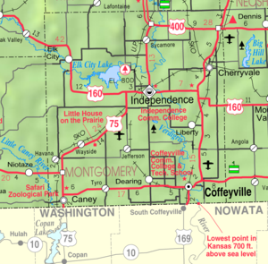
Unincorporated area
In law, an unincorporated area is a region of land that is not a part of any municipality.To "incorporate" in this context means to form a municipal corporation, a city, town, or village with its own government. An unincorporated community is usually not subject to or taxed by a municipal government...
in northern Montgomery County
Montgomery County, Kansas
Montgomery County is a county located in southeast Kansas, in the Central United States. As of the 2010 census, the county population was 35,471. Its county seat is Independence, and its most populous city is Coffeyville. The Coffeyville Micropolitan Statistical Area includes all of Montgomery...
, Kansas
Kansas
Kansas is a US state located in the Midwestern United States. It is named after the Kansas River which flows through it, which in turn was named after the Kansa Native American tribe, which inhabited the area. The tribe's name is often said to mean "people of the wind" or "people of the south...
, United States
United States
The United States of America is a federal constitutional republic comprising fifty states and a federal district...
. It lies along U.S. Route 75
U.S. Route 75
U.S. Route 75 is a north–south U.S. Highway. The highway's northern terminus is in Kittson County, Minnesota, at the Canadian border, where it continues as Manitoba Highway 75 on the other side of a closed border crossing. Its southern terminus is at Interstate 30 and Interstate 45 in Dallas,...
north of the city of Independence
Independence, Kansas
Independence is a city in and the county seat of Montgomery County, Kansas, United States. As of the 2010 census, the city population was 9,483.-Geography:...
, the county seat
County seat
A county seat is an administrative center, or seat of government, for a county or civil parish. The term is primarily used in the United States....
of Montgomery County. Its elevation is 843 feet (257 m), and it is located at 37°19′37"N 95°42′56"W (37.3270085, -95.7155358). Although it is unincorporated, it has a post office
Post office
A post office is a facility forming part of a postal system for the posting, receipt, sorting, handling, transmission or delivery of mail.Post offices offer mail-related services such as post office boxes, postage and packaging supplies...
, with the ZIP code
ZIP Code
ZIP codes are a system of postal codes used by the United States Postal Service since 1963. The term ZIP, an acronym for Zone Improvement Plan, is properly written in capital letters and was chosen to suggest that the mail travels more efficiently, and therefore more quickly, when senders use the...
of 67363.