

Sweetwater Dam
Encyclopedia
The Sweetwater Dam is a dam across the Sweetwater River
in San Diego County
, California
. As the crow flies
, it sits about 12 miles (19.3 km) east of San Diego
and 9 miles (14.5 km) northeast of Chula Vista
; and just south of the city of La Presa
. The 108 feet (32.9 m)-high masonry arch dam impounds 960 acres (388.5 ha) Sweetwater Reservoir
.
The dam was first constructed in 1888 as part of a system of reservoirs on San Diego County rivers designed to provide water to irrigate crops along the coast and to supply the city of San Diego and its outlying towns. Over the next few decades the dam was raised and retrofitted several times from its original height of 60 feet (18.3 m). In 1916, a heavy flood caused both abutments of the dam to fail. Fortunately, the rest of the dam did not sustain heavy damage and it remains in use today serving flood control, water storage and recreation.
, straddling the Sweetwater River to form a reservoir capable of holding 28079 acre.ft of water. It is 108 feet (32.9 m) high and 700 feet (213.4 m) long, with a thickness of 46 feet (14 m) at the base. It is equipped with an intake tower on the upstream end connected to a high-pressure conduit that cuts through the base of the dam designed to release water from different depths of the reservoir; if water is released from a lower elevation the outflow will be greater. However, due to the low flow of the river, there is typically only a trickle of water below the dam as it impounds all the inflow from upstream. Occasional large floods do hit the area, so the dam is designed to survive overtoppings and also has a pair of seven-gated spillways capable of handling more than 45000 cuft/s.
The dam is operated in conjunction with Loveland Dam
and its reservoir approximately 19 miles (30.6 km) upstream for flood control purposes. The dam serves as a backup water storage facility for the San Diego metropolitan area today in the case of drought, and provides some local municipal water. The reservoir serves for wildlife management and recreation among other uses.
 Despite having a mild climate and fertile soils, the San Diego area has a semiarid climate, and thus in its rivers most of the flow occur during the winter months, causing devastating floods. Conversely, in the summer, most of the smaller streams dry up and the larger waterways are reduced to trickles, leading to equally dangerous droughts. The Sweetwater River, along with others such as the San Diego River
and the San Luis Rey River
, was one of the few streams that did flow with abundance year round. As the population of the region grew, however, the river could no longer provide what was needed in the dry season.
One of the area's early settlers, Frank Kimball, was the first to suggest the building of a dam on this particular reach of the Sweetwater River in 1869. Here the river after departing a broad valley cuts through a steep and narrow gorge, providing an ideal site for a reservoir. The original blueprints for the dam, drawn by a F. E. Brown, called for a thin-arch dam 50 feet (15.2 m) high and barely wider on its crest than at its base, capable of holding some 3700 acre.ft. Groundbreaking of the dam was on November 17, 1886 and a quarry was excavated on the south side of the gorge early the following year to provide masonry rubble for the dam.
As construction progressed, the original thin arch design was considered both unstable and inadequate for the county's growing water needs. Thus the projected height of the dam was increased to 60 feet (18.3 m) and the base thickness increased by 26 feet (7.9 m). A series of specialized stone steps were constructed on the faces of the dam to provide for future increases in height.
The stone used in the dam's construction was quarried from a large rock outcropping about 800 feet (243.8 m) downstream on the south bank of the river. There were two types of stone, both metamorphic and one iron-rich, and both were considered excellent for the dam's construction. Sand was excavated from the river bottom for use in cement mixing; this was also declared exceptionally suitable. As the dam rose to a height of 45 feet (13.7 m), the outlet tunnel at the base was sealed, and the water rose behind the structure to a controlled depth of 35 feet (10.7 m) for leakage testing purposes. The dam held and no significant seepage was recorded.
Horses and mules were used to transport stone from the quarry to the dam site using carts. At the construction site, four to five derrick
s ranging in height from 30 to 50 ft (9.1 to 15.2 m) were used to facilitate placement of the stone and cement, bucket by bucket, the latter of which was being made on-site. The dam was topped out on April 7, 1888 to a height of 90 feet (27.4 m) above its foundations. To the south of the structure was constructed the spillway or "waste weir", consisting of eight overflow channels separated by masonry piers. Controlled by a series of wooden boards, the spillway could handle up to 1500 cuft/s.
A total of 20507 cubic yards (15,678.7 m³) of material were used in the construction of the dam, including 17,562 barrels of cement. The total cost came to $234,074.11, including preliminary investigations and purchase of the land to be flooded by the reservoir. The dedication ceremony was on April 19, and over three thousand people came to watch. At that time, the dam was the highest masonry arch dam in the United States and was considered an engineering marvel and tourist attraction.
, known as "the Rainmaker". The city promised Hatfield $10,000 if he could make it rain significantly by the end of the year. Hatfield's venture was apparently a success, but it is not known what actually caused the massive floods that tore through the county beginning December 9, the day after he started his inconspicuous scheme.
More than thirty-nine inches (991 mm) of rain fell during the following month, and storms continued deluging the county well into early 1916. The area's rivers and streams rose to their highest recorded levels in years. More than 200 bridges were washed out, entire communities were swept away, levees collapsed, and valleys were inundated. All the bridges along the San Diego, Sweetwater and Otay rivers were washed out except for a rail bridge that was left standing alone with its ends missing. The earthen Otay Dam, several miles southeast of the Sweetwater on the Otay River
, burst on January 27 sending a wall of water into southern Chula Vista. Flooding deposited so much sediment that the southern end of San Diego Bay
was filled with it – much of the sand remains today in the form of shoals that must be periodically dredged to accommodate boat traffic.
The Sweetwater River rose and rose until it reached a peak flow of 45500 cuft/s on January 30, 1916; now even the dam's increased height and spillway capacity did little to prevent it from overflowing. The reservoir overtopped the dam crest by 3.5 feet (1.1 m) in an event similar to but far larger than 1895. The river breached the north abutment of the dam, then soon after the south end just left of the spillway went with it. Like in 1895, the main structure of the dam was not heavily damaged but the river eroded enough material around the structure to drain two-thirds of the reservoir in a floodwave. The failure of the dam caused extensive damage downstream, including the destruction of over 15000 ft (4,572 m) of Sweetwater Water Co. pipeline, all railway track and electric utility lines. The dam was subsequently rebuilt and an additional spillway added to pass future floods.
.
Sweetwater River (California)
The Sweetwater River is a long stream in southwestern California in the United States. From its headwaters high in the Cuyamaca Mountains, the river flows generally southwest, first through rugged hinterlands but then into the urban areas surrounding its mouth at San Diego Bay. Its drainage basin...
in San Diego County
San Diego County, California
San Diego County is a large county located in the southwestern corner of the US state of California. Hence, San Diego County is also located in the southwestern corner of the 48 contiguous United States. Its county seat and largest city is San Diego. Its population was about 2,813,835 in the 2000...
, California
California
California is a state located on the West Coast of the United States. It is by far the most populous U.S. state, and the third-largest by land area...
. As the crow flies
As the crow flies
"As the crow flies" or beelining is an idiom for the shortest route between two points; the geodesic distance.An example is the great-circle distance between Key West and Pensacola, at either end of the U.S...
, it sits about 12 miles (19.3 km) east of San Diego
San Diego, California
San Diego is the eighth-largest city in the United States and second-largest city in California. The city is located on the coast of the Pacific Ocean in Southern California, immediately adjacent to the Mexican border. The birthplace of California, San Diego is known for its mild year-round...
and 9 miles (14.5 km) northeast of Chula Vista
Chula Vista, California
Chula Vista is the second largest city in the San Diego metropolitan area, the seventh largest city in Southern California, the fourteenth largest city in the State of California, and the seventy seventh largest city in the U.S....
; and just south of the city of La Presa
La Presa, California
La Presa is a census-designated place in San Diego County, California, United States. The population of was 34,169 at the 2010 census, up from 32,721 at the 2000 census...
. The 108 feet (32.9 m)-high masonry arch dam impounds 960 acres (388.5 ha) Sweetwater Reservoir
Sweetwater Reservoir
Sweetwater Reservoir is a artificial lake in San Diego County, California formed by the Sweetwater Dam on the Sweetwater River. It lies near the city of Spring Valley....
.
The dam was first constructed in 1888 as part of a system of reservoirs on San Diego County rivers designed to provide water to irrigate crops along the coast and to supply the city of San Diego and its outlying towns. Over the next few decades the dam was raised and retrofitted several times from its original height of 60 feet (18.3 m). In 1916, a heavy flood caused both abutments of the dam to fail. Fortunately, the rest of the dam did not sustain heavy damage and it remains in use today serving flood control, water storage and recreation.
Design
Sweetwater Dam is a concrete thick gravity-arch typeArch dam
An arch dam is a type of dam that is curved and commonly built with concrete. The arch dam is a structure that is designed to curve upstream so that the force of the water against it, known as hydrostatic pressure, presses against the arch, compressing and strengthening the structure as it pushes...
, straddling the Sweetwater River to form a reservoir capable of holding 28079 acre.ft of water. It is 108 feet (32.9 m) high and 700 feet (213.4 m) long, with a thickness of 46 feet (14 m) at the base. It is equipped with an intake tower on the upstream end connected to a high-pressure conduit that cuts through the base of the dam designed to release water from different depths of the reservoir; if water is released from a lower elevation the outflow will be greater. However, due to the low flow of the river, there is typically only a trickle of water below the dam as it impounds all the inflow from upstream. Occasional large floods do hit the area, so the dam is designed to survive overtoppings and also has a pair of seven-gated spillways capable of handling more than 45000 cuft/s.
The dam is operated in conjunction with Loveland Dam
Loveland Dam
Loveland Dam is a dam across the Sweetwater River in San Diego County, California. The dam forms long, narrow Loveland Reservoir which stores of water...
and its reservoir approximately 19 miles (30.6 km) upstream for flood control purposes. The dam serves as a backup water storage facility for the San Diego metropolitan area today in the case of drought, and provides some local municipal water. The reservoir serves for wildlife management and recreation among other uses.
Planning
San Diego River
The San Diego River is a river in San Diego County, California. It originates in the Cuyamaca Mountains northwest of the town of Julian, then flows to the southwest until it reaches the El Capitan Reservoir, the largest reservoir in the river's watershed at . Below El Capitan Dam, the river runs...
and the San Luis Rey River
San Luis Rey River
The San Luis Rey River is a river in northern San Diego County, California. The river's headwaters are in the Cleveland National Forest near Palomar Mountain. The river drains into the Pacific Ocean on the northern end of the city of Oceanside. The river is over long and drains...
, was one of the few streams that did flow with abundance year round. As the population of the region grew, however, the river could no longer provide what was needed in the dry season.
One of the area's early settlers, Frank Kimball, was the first to suggest the building of a dam on this particular reach of the Sweetwater River in 1869. Here the river after departing a broad valley cuts through a steep and narrow gorge, providing an ideal site for a reservoir. The original blueprints for the dam, drawn by a F. E. Brown, called for a thin-arch dam 50 feet (15.2 m) high and barely wider on its crest than at its base, capable of holding some 3700 acre.ft. Groundbreaking of the dam was on November 17, 1886 and a quarry was excavated on the south side of the gorge early the following year to provide masonry rubble for the dam.
Construction
Following groundbreaking, the dam's foundations were laid by the San Diego Land and Town Company as a large stone-and-cement block 36 feet (11 m) thick and 15 feet (4.6 m) high. During the early stages of construction the Sweetwater River was diverted underneath the foundation structure into a square masonry culvert 30 inches (76.2 cm) in diameter. The tunnel provided sufficient discharge capacity for the river past the dam site, as 1886–1887 were below average precipitation years. However, in February 1887, the river swelled due to a minor storm and overflowed the foundations for two days. No significant damage was wrought.As construction progressed, the original thin arch design was considered both unstable and inadequate for the county's growing water needs. Thus the projected height of the dam was increased to 60 feet (18.3 m) and the base thickness increased by 26 feet (7.9 m). A series of specialized stone steps were constructed on the faces of the dam to provide for future increases in height.
The stone used in the dam's construction was quarried from a large rock outcropping about 800 feet (243.8 m) downstream on the south bank of the river. There were two types of stone, both metamorphic and one iron-rich, and both were considered excellent for the dam's construction. Sand was excavated from the river bottom for use in cement mixing; this was also declared exceptionally suitable. As the dam rose to a height of 45 feet (13.7 m), the outlet tunnel at the base was sealed, and the water rose behind the structure to a controlled depth of 35 feet (10.7 m) for leakage testing purposes. The dam held and no significant seepage was recorded.
Horses and mules were used to transport stone from the quarry to the dam site using carts. At the construction site, four to five derrick
Derrick
A derrick is a lifting device composed of one tower, or guyed mast such as a pole which is hinged freely at the bottom. It is controlled by lines powered by some means such as man-hauling or motors, so that the pole can move in all four directions. A line runs up it and over its top with a hook on...
s ranging in height from 30 to 50 ft (9.1 to 15.2 m) were used to facilitate placement of the stone and cement, bucket by bucket, the latter of which was being made on-site. The dam was topped out on April 7, 1888 to a height of 90 feet (27.4 m) above its foundations. To the south of the structure was constructed the spillway or "waste weir", consisting of eight overflow channels separated by masonry piers. Controlled by a series of wooden boards, the spillway could handle up to 1500 cuft/s.
A total of 20507 cubic yards (15,678.7 m³) of material were used in the construction of the dam, including 17,562 barrels of cement. The total cost came to $234,074.11, including preliminary investigations and purchase of the land to be flooded by the reservoir. The dedication ceremony was on April 19, and over three thousand people came to watch. At that time, the dam was the highest masonry arch dam in the United States and was considered an engineering marvel and tourist attraction.
1911 expansion
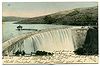
In the winter of 1895, heavy rains caused the Sweetwater River to rise to record levels, and the dam's outlets and spillways were unable to handle the excess inflow of water. For more than 40 hours during the peak of the storm, the reservoir overtopped the dam by nearly two feet, spilling over in a massive waterfall. The floods caused severe damage to the abutments of the dam and eroded the riverbed below, but the dam survived. In response to the danger of future floods, work began in 1910 to raise the dam to a height of 110 feet (33.5 m). To do this, a 20 feet (6.1 m)-tall vertical masonry parapet was added to the top of the dam, the spillways were reconstructed, and the intake tower was raised. This was finished in 1911, and gave the reservoir an additional capacity of about 4000 acre.ft.1916 failure
In the winter of 1915, southern California was experiencing a devastating drought that had drained area reservoirs to record low levels over more than three consecutive years, causing massive agricultural and ranching losses. Residents of San Diego County were so desperate that the city of San Diego hired a man called Charles HatfieldCharles Hatfield
Charles Mallory Hatfield was an American "rainmaker". He was born in Fort Scott, Kansas in 1875 or 1876. His family moved to southern California in the 1880s. As an adult, he became a salesman for the New Home Sewing Machine Company...
, known as "the Rainmaker". The city promised Hatfield $10,000 if he could make it rain significantly by the end of the year. Hatfield's venture was apparently a success, but it is not known what actually caused the massive floods that tore through the county beginning December 9, the day after he started his inconspicuous scheme.
More than thirty-nine inches (991 mm) of rain fell during the following month, and storms continued deluging the county well into early 1916. The area's rivers and streams rose to their highest recorded levels in years. More than 200 bridges were washed out, entire communities were swept away, levees collapsed, and valleys were inundated. All the bridges along the San Diego, Sweetwater and Otay rivers were washed out except for a rail bridge that was left standing alone with its ends missing. The earthen Otay Dam, several miles southeast of the Sweetwater on the Otay River
Otay River
The Otay River is a river in southern San Diego County, California. The river begins at San Miguel Mountain, flows through the Upper- and Lower- Otay Reservoirs, and continues on between the southern part of the Chula Vista and the Otay Mesa West district of San Diego, and empties into San Diego Bay...
, burst on January 27 sending a wall of water into southern Chula Vista. Flooding deposited so much sediment that the southern end of San Diego Bay
San Diego Bay
San Diego Bay is a natural harbor and deepwater port adjacent to San Diego, California. It is 12 mi/19 km long, 1 mi/1.6 km–3 mi/4.8 km wide...
was filled with it – much of the sand remains today in the form of shoals that must be periodically dredged to accommodate boat traffic.
The Sweetwater River rose and rose until it reached a peak flow of 45500 cuft/s on January 30, 1916; now even the dam's increased height and spillway capacity did little to prevent it from overflowing. The reservoir overtopped the dam crest by 3.5 feet (1.1 m) in an event similar to but far larger than 1895. The river breached the north abutment of the dam, then soon after the south end just left of the spillway went with it. Like in 1895, the main structure of the dam was not heavily damaged but the river eroded enough material around the structure to drain two-thirds of the reservoir in a floodwave. The failure of the dam caused extensive damage downstream, including the destruction of over 15000 ft (4,572 m) of Sweetwater Water Co. pipeline, all railway track and electric utility lines. The dam was subsequently rebuilt and an additional spillway added to pass future floods.
Later events
In 1939 and 1940, the dam received a major overhaul in which the 1911 parapet was lowered by two feet and built into an emergency spillway as the two existing spillways were considered insufficient to handle large floods. The dam then came under the ownership of the Sweetwater Authority, which still runs the dam today. In the late 20th century, a new concrete coating was applied to the dam in an attempt to stop leakage. However, the dam's spillways were still considered inadequate to handle more than 20 percent of a "probable maximum flood". On April 7, 2006, the Sweetwater Dam was recognized as a Historic Civil Engineering Landmark by the American Society of Civil EngineersAmerican Society of Civil Engineers
The American Society of Civil Engineers is a professional body founded in 1852 to represent members of the civil engineering profession worldwide. It is the oldest national engineering society in the United States. ASCE's vision is to have engineers positioned as global leaders who strive toward...
.