
.gif)
Sugar Island (Maine)
Encyclopedia
Island
An island or isle is any piece of sub-continental land that is surrounded by water. Very small islands such as emergent land features on atolls can be called islets, cays or keys. An island in a river or lake may be called an eyot , or holm...
located in Maine
Maine
Maine is a state in the New England region of the northeastern United States, bordered by the Atlantic Ocean to the east and south, New Hampshire to the west, and the Canadian provinces of Quebec to the northwest and New Brunswick to the northeast. Maine is both the northernmost and easternmost...
's Moosehead Lake
Moosehead Lake
Moosehead Lake is the largest lake in the U.S. state of Maine and the largest mountain lake in the eastern United States. Situated in the Longfellow Mountains in the Maine Highlands Region, the lake is the source of the Kennebec River. Towns that border the lake include Greenville to the south and...
. It is roughly four miles long and two miles wide (at its widest/longest points). Sugar Island is Moosehead Lake's largest island.
Sugar Island is mainly accessed through Lily Bay State Park, and takes about five minutes from the state park by boat. There is a fee at the state park of three dollars.
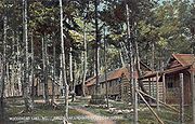
There are two resident camps on Sugar Island on the South side which have been frequented by three generations of family members and friends year after year. In the year 2000 census, the families were not there however, so the population is officially 0.