

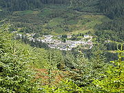
Strathyre
Encyclopedia
Stirling (council area)
Stirling is one of the 32 unitary local government council areas of Scotland, and has a population of about 87,000 . It was created under the Local Government etc Act 1994 with the boundaries of the Stirling district of the former Central local government region, and it covers most of the former...
local government district of Scotland
Scotland
Scotland is a country that is part of the United Kingdom. Occupying the northern third of the island of Great Britain, it shares a border with England to the south and is bounded by the North Sea to the east, the Atlantic Ocean to the north and west, and the North Channel and Irish Sea to the...
. It forms the south-eastern part of the parish of Balquhidder
Balquhidder
Balquhidder is a small village in the Stirling council area of Scotland. It is overlooked by the dramatic mountain terrain of the Braes of Balquhidder, at the head of Loch Voil. Balquhidder Glen is also popular for fishing, nature watching and walking...
and was, prior to the 1973 reorganisation of local government, part of Perthshire
Perthshire
Perthshire, officially the County of Perth , is a registration county in central Scotland. It extends from Strathmore in the east, to the Pass of Drumochter in the north, Rannoch Moor and Ben Lui in the west, and Aberfoyle in the south...
. It is within the bounds of the Loch Lomond and the Trossachs National Park
Loch Lomond and the Trossachs National Park
Loch Lomond and The Trossachs National Park is a national park in Scotland centred on Loch Lomond, and includes several ranges of hills, the Trossachs being the most famous...
.
The district of Strathyre extends from east of Balquhidder, following the River Balvaig
River Balvaig
The River Balvaig is a short river approximately long draining from the head of Loch Voil near Balquhidder and then southwards through the village of Strathyre before flowing into the northern end of Loch Lubnaig....
which flows out of Loch Voil
Loch Voil
Loch Voil is a small freshwater loch in Scotland. It is a short, narrow loch approximately 5 km in length, It is separated from Loch Doine by the River Larig and is drained at its northern end by the River Balvaig at Balquhidder. The Loch can be reached by a small single track road from...
, almost due south to Loch Lubnaig
Loch Lubnaig
Loch Lubnaig is a small loch near Callander in the Stirling council area, Scotland. It lies in the former county of Perthshire....
. The River Balvaig
River Balvaig
The River Balvaig is a short river approximately long draining from the head of Loch Voil near Balquhidder and then southwards through the village of Strathyre before flowing into the northern end of Loch Lubnaig....
is 8 kilometres in length, almost all of which lies in Strathyre. It falls by around 5 metres between Loch Voil and Loch Lubnaig. The A84 road
A84 road
The A84 is a major road in Scotland, United Kingdom. It links the city of Stirling with Lochearnhead, running an approximate .-Road safety:The A84 between M9 Junction 10 and Lochearnhead has a poor road safety record, according to EuroRAP...
and the route of the former Callander and Oban Railway
Callander and Oban Railway
The Callander and Oban Railway company was formed in 1864 with the objective of linking Callander, Scotland to the west coast port of Oban over challenging terrain, particularly at Glen Ogle and the Pass of Brander at Loch Awe. Callander had been reached in 1858 by the Dunblane, Doune and Callander...
run through the valley, as does the old 18th century military road.
The Strathyre Forest, which extends well beyond the limits of Strathyre proper, is managed by the Forestry Commission
Forestry Commission
The Forestry Commission is a non-ministerial government department responsible for forestry in Great Britain. Its mission is to protect and expand Britain's forests and woodlands and increase their value to society and the environment....
, forming the eastern-most part of the Queen Elizabeth Forest Park.
The village of Strathyre is largely a Victorian creation, having grown up with the arrival of the railway in the 1870s and the establishment of Strathyre railway station
Strathyre railway station
Strathyre was a railway station located at the head of Loch Lubnaig, Stirling, in Strathyre.-History:This station opened on 1 June 1870 along with the first section of the Callander and Oban Railway, between Callander and Glenoglehead .The station was laid out with two platforms, one on either side...
. The resident population recorded by the United Kingdom Census 2001
United Kingdom Census 2001
A nationwide census, known as Census 2001, was conducted in the United Kingdom on Sunday, 29 April 2001. This was the 20th UK Census and recorded a resident population of 58,789,194....
was around 100. The village is a popular tourist centre, with nearby caravan parks, camp sites and chalets, and canoeing, cycling and walking facilities.