
Standburn
Encyclopedia
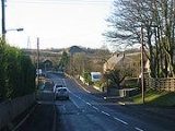
Standburn is a small village which lies within the Falkirk council area
in central Scotland
. It is located 1.3 miles (2.1 km) south-west of Maddiston
, 1.7 miles (2.7 km) north-east of Avonbridge
and 4 miles (6.4 km) south east of Falkirk
. The entire village is located along a section of the B825 road between Avonbridge
and Loan.
 The United Kingdom Census 2001
reported the population as 149 residents, a figure almost unchanged from the census of 1991
Drumbowie Environment Action Group is a charitable organisation which owns Drumbowie Park to the north of Standburn, this community woodland is open to the public.
Standburn was a mining community with several active pits until the 1950s. The pits were individually numbered and all prefixed by Gateside. The bings from the mining days can still be seen although the land has now been planted with trees and named Gateside Woodland.
Falkirk (council area)
Falkirk is one of the 32 unitary authority council areas in Scotland. It borders onto North Lanarkshire to the south west, Stirling to the north west, West Lothian to the south east and, across the Firth of Forth to the north east, Fife and Clackmannanshire...
in central Scotland
Scotland
Scotland is a country that is part of the United Kingdom. Occupying the northern third of the island of Great Britain, it shares a border with England to the south and is bounded by the North Sea to the east, the Atlantic Ocean to the north and west, and the North Channel and Irish Sea to the...
. It is located 1.3 miles (2.1 km) south-west of Maddiston
Maddiston
Maddiston is a village in the Falkirk council area of Scotland. It lies west-southwest of Linlithgow, south of Polmont and south-east of Rumford at the south-east edge of the Falkirk urban area....
, 1.7 miles (2.7 km) north-east of Avonbridge
Avonbridge
Avonbridge is a small village which lies within the Falkirk council area of Scotland. The village is south-southeast of the town of Falkirk. Avonbridge sits just inside the council boundary line between Falkirk and West Lothian councils....
and 4 miles (6.4 km) south east of Falkirk
Falkirk
Falkirk is a town in the Central Lowlands of Scotland. It lies in the Forth Valley, almost midway between the two most populous cities of Scotland; north-west of Edinburgh and north-east of Glasgow....
. The entire village is located along a section of the B825 road between Avonbridge
Avonbridge
Avonbridge is a small village which lies within the Falkirk council area of Scotland. The village is south-southeast of the town of Falkirk. Avonbridge sits just inside the council boundary line between Falkirk and West Lothian councils....
and Loan.
United Kingdom Census 2001
A nationwide census, known as Census 2001, was conducted in the United Kingdom on Sunday, 29 April 2001. This was the 20th UK Census and recorded a resident population of 58,789,194....
reported the population as 149 residents, a figure almost unchanged from the census of 1991
United Kingdom Census 1991
A nationwide census, commonly known as Census 1991, was conducted in the United Kingdom on Sunday 21 April 1991. This was the 19th UK census....
Drumbowie Environment Action Group is a charitable organisation which owns Drumbowie Park to the north of Standburn, this community woodland is open to the public.
Standburn was a mining community with several active pits until the 1950s. The pits were individually numbered and all prefixed by Gateside. The bings from the mining days can still be seen although the land has now been planted with trees and named Gateside Woodland.