
St Martin's, Guernsey
Encyclopedia
Saint Martin is a parish in Guernsey
, English Channel Islands
. The islands lie in the English Channel
between Great Britain
and France
.
The postal code for street addresses in this parish begins with GY4.
The old Guernésiais nickname for people from Saint Martin is dravans.
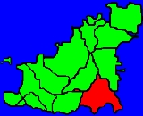
 Saint Martin is located in the southeast of Guernsey
. The parish
borders the Forest
on the southwest, Saint Andrew northwest, and Saint Peter Port on the northeast. Saint Martin also has a very small detachment to the west. The detachment is an exclave which is not contiguous with the rest of the parish.
Saint Martin is one of the most expensive parishes in the island for property, with the average four bedroom house costing £615,000.
The local football club is Saint Martins AC.
. The highest areas in the parish are in the central portion, but this gently slopes down to the boundaries, where on the coast, the parish is delineated by steep cliffs.
 The features of the parish include:
The following roads are also very important, as they provide access to the village centre and most of the shops (listed from west to east):
Guernsey
Guernsey, officially the Bailiwick of Guernsey is a British Crown dependency in the English Channel off the coast of Normandy.The Bailiwick, as a governing entity, embraces not only all 10 parishes on the Island of Guernsey, but also the islands of Herm, Jethou, Burhou, and Lihou and their islet...
, English Channel Islands
Channel Islands
The Channel Islands are an archipelago of British Crown Dependencies in the English Channel, off the French coast of Normandy. They include two separate bailiwicks: the Bailiwick of Guernsey and the Bailiwick of Jersey...
. The islands lie in the English Channel
English Channel
The English Channel , often referred to simply as the Channel, is an arm of the Atlantic Ocean that separates southern England from northern France, and joins the North Sea to the Atlantic. It is about long and varies in width from at its widest to in the Strait of Dover...
between Great Britain
Great Britain
Great Britain or Britain is an island situated to the northwest of Continental Europe. It is the ninth largest island in the world, and the largest European island, as well as the largest of the British Isles...
and France
France
The French Republic , The French Republic , The French Republic , (commonly known as France , is a unitary semi-presidential republic in Western Europe with several overseas territories and islands located on other continents and in the Indian, Pacific, and Atlantic oceans. Metropolitan France...
.
The postal code for street addresses in this parish begins with GY4.
The old Guernésiais nickname for people from Saint Martin is dravans.
Geography
Guernsey
Guernsey, officially the Bailiwick of Guernsey is a British Crown dependency in the English Channel off the coast of Normandy.The Bailiwick, as a governing entity, embraces not only all 10 parishes on the Island of Guernsey, but also the islands of Herm, Jethou, Burhou, and Lihou and their islet...
. The parish
Civil parish
In England, a civil parish is a territorial designation and, where they are found, the lowest tier of local government below districts and counties...
borders the Forest
Forest, Guernsey
The Forest is a parish in Guernsey. It is the highest parish on the island, with altitudes of up to about 100 m. The full title being Ste Margurite de la Foret after the parish church....
on the southwest, Saint Andrew northwest, and Saint Peter Port on the northeast. Saint Martin also has a very small detachment to the west. The detachment is an exclave which is not contiguous with the rest of the parish.
Saint Martin is one of the most expensive parishes in the island for property, with the average four bedroom house costing £615,000.
The local football club is Saint Martins AC.
Beaches
The coast has many cliffs, but the beaches in Saint Martin include (from southwest to northeast):- part of Petit Bot Bay (ˈpɛti ˈboʊ)
- Saint's Bay
- Moulin Huet (ˈmʊlɨn ˈwɛt)
- Petit Port
- Marble Bay - also known as Le Pied du Mur
- Part of Fermain Bay
Relief
Saint Martin is the second highest parish in Guernsey, its elevation is exceeded only by the ForestForest, Guernsey
The Forest is a parish in Guernsey. It is the highest parish on the island, with altitudes of up to about 100 m. The full title being Ste Margurite de la Foret after the parish church....
. The highest areas in the parish are in the central portion, but this gently slopes down to the boundaries, where on the coast, the parish is delineated by steep cliffs.
Features
- Jerbourg Point, the most southeasterly point in the island,
- Moulin Huet Bay, a large area of water that includes Saint's Bay, Moulin Huet, and Petit Port.
- St Martin's Parish Church and Cemetery
- Sausmarez Manor
Main roads
The following roads provide important links between Saint Martin and the other parishes (listed from southwest to northeast):- Forest Road leads to the ForestForest, GuernseyThe Forest is a parish in Guernsey. It is the highest parish on the island, with altitudes of up to about 100 m. The full title being Ste Margurite de la Foret after the parish church....
and the western portion of the island, - Les Varioufs leads to Saint Andrew'sSt Andrew's, GuernseySaint Andrew is located in the centre of Guernsey and as such is the only parish on the island to be landlocked.The post code for addresses in this parish starts with GY6.-Geography:...
and the northwestern portion of the island, - Fort Road leads to Saint Peter Port, the east coast, and the northern portion of the island.
The following roads are also very important, as they provide access to the village centre and most of the shops (listed from west to east):
- Rue Maze
- La Grande Rue