

Spuyten Duyvil Creek
Encyclopedia
Spuyten Duyvil Creek is a channel connecting the Hudson River
Hudson River
The Hudson is a river that flows from north to south through eastern New York. The highest official source is at Lake Tear of the Clouds, on the slopes of Mount Marcy in the Adirondack Mountains. The river itself officially begins in Henderson Lake in Newcomb, New York...
to the Harlem River Ship Canal
Harlem River Ship Canal
The Harlem River Ship Canal is a channel connecting the Hudson River and Spuyten Duyvil Creek to the Harlem River in New York City, separating the neighborhood of Marble Hill from the island of Manhattan...
, and on to the Harlem River
Harlem River
The Harlem River is a navigable tidal strait in New York City, USA that flows 8 miles between the Hudson River and the East River, separating the boroughs of Manhattan and the Bronx...
in New York City
New York City
New York is the most populous city in the United States and the center of the New York Metropolitan Area, one of the most populous metropolitan areas in the world. New York exerts a significant impact upon global commerce, finance, media, art, fashion, research, technology, education, and...
, separating the island of Manhattan
Manhattan
Manhattan is the oldest and the most densely populated of the five boroughs of New York City. Located primarily on the island of Manhattan at the mouth of the Hudson River, the boundaries of the borough are identical to those of New York County, an original county of the state of New York...
from the Bronx
The Bronx
The Bronx is the northernmost of the five boroughs of New York City. It is also known as Bronx County, the last of the 62 counties of New York State to be incorporated...
and the rest of the mainland. The neighborhood named Spuyten Duyvil
Spuyten Duyvil, Bronx
Spuyten Duyvil is the name of a subsection of the Riverdale section of the Bronx in New York City. The area is named after Spuyten Duyvil Creek, a Dutch name with various historical spellings and meanings, the most plausible of which is "Spinning Devil", "Devil's Whirlpool", or "Devil's Spate"...
lies to the north of the creek.
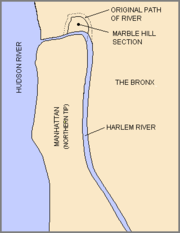
Spuyten Duyvil Creek originally flowed north of Manhattan's Marble Hill
Marble Hill, Manhattan
Marble Hill is the neighborhood which makes up the northernmost part of the Borough of Manhattan in New York City, United States. Although it is politically part of Manhattan and New York County, because of the re-routing of the Harlem River, it is located on the North American mainland contiguous...
. The construction of the Harlem River Ship Canal to the south of the neighborhood in 1895 turned Marble Hill into an island, and in 1914, when the original creekbed was filled in, Marble Hill became physically attached to the Bronx, though it remains part of the borough of Manhattan.
Another realignment of the creek occurred in the 1930s, to the west of the original realignment. This had the opposite effect: It separated a portion of the Bronx and resulted in its attachment to Manhattan as a small peninsula where the Inwood Hill Park
Inwood Hill Park
Inwood Hill Park is a city-owned and maintained public park in Inwood, Upper Manhattan, New York City, operated by the New York City Department of Parks and Recreation. It stretches along the Hudson River from Dyckman Street to the northern tip of the island. Inwood Hill Park's densely folded,...
Nature Center is now situated.
"Spuyten Duyvil" literally means "Devil's Spout" or Spuitende Duivel in Dutch
Dutch language
Dutch is a West Germanic language and the native language of the majority of the population of the Netherlands, Belgium, and Suriname, the three member states of the Dutch Language Union. Most speakers live in the European Union, where it is a first language for about 23 million and a second...
; a reference to the strong and wild currents found at that location.