
South Williamson, Kentucky
Encyclopedia
Unincorporated area
In law, an unincorporated area is a region of land that is not a part of any municipality.To "incorporate" in this context means to form a municipal corporation, a city, town, or village with its own government. An unincorporated community is usually not subject to or taxed by a municipal government...
in the Appalachian Mountains
Appalachian Mountains
The Appalachian Mountains #Whether the stressed vowel is or ,#Whether the "ch" is pronounced as a fricative or an affricate , and#Whether the final vowel is the monophthong or the diphthong .), often called the Appalachians, are a system of mountains in eastern North America. The Appalachians...
of northeastern Pike County
Pike County, Kentucky
Pike County is a county located in the U.S. state of Kentucky. As of 2010, the population was 65,024. Its county seat is Pikeville. Pike is Kentucky's largest county in terms of land area. Pike County is the 11th largest county in Kentucky in terms of population preceded by Bullitt County and...
, Kentucky
Kentucky
The Commonwealth of Kentucky is a state located in the East Central United States of America. As classified by the United States Census Bureau, Kentucky is a Southern state, more specifically in the East South Central region. Kentucky is one of four U.S. states constituted as a commonwealth...
, borders with West Virginia
West Virginia
West Virginia is a state in the Appalachian and Southeastern regions of the United States, bordered by Virginia to the southeast, Kentucky to the southwest, Ohio to the northwest, Pennsylvania to the northeast and Maryland to the east...
. It is separated from Williamson, West Virginia
Williamson, West Virginia
Williamson is a city in Mingo County, West Virginia, USA, along the Tug Fork River. The population was 3,414 at the 2000 census. It is the county seat of Mingo County, and is the county's largest and most populous city. Williamson is home to Southern West Virginia Community and Technical College...
by the Tug Fork River
Tug Fork River
The Tug Fork is a tributary of the Big Sandy River, long, in southwestern West Virginia, southwestern Virginia, and eastern Kentucky in the United States. Via the Big Sandy and Ohio rivers, it is part of the watershed of the Mississippi River....
. The town is located 23 miles east of Pikeville, Kentucky
Pikeville, Kentucky
Pikeville is a city in Pike County, Kentucky. The population was 6,903 at the 2010 census. It is the county seat of Pike County.-History:On March 25, 1822, the county's government officials decided to build a new county seat named Liberty, one and one-half mile below the mouth of the Russell Fork...
and 28 miles southwest of Logan, West Virginia
Logan, West Virginia
Logan is a city in Logan County, West Virginia, United States, along the Guyandotte River. The population was 1,779 at the 2010 census. It is the county seat of Logan County.-History:...
, and can be accessed via U.S. Route 119
U.S. Route 119
U.S. Route 119, commonly abbreviated as US 119, is a spur of US 19. It is a north–south route that was an original United States highway of 1926. It is often referred to as Corridor G east of US 23 and KY 80 in Kentucky to Interstate 64 at Charleston, West Virginia.- Kentucky :US 119 is a two...
.
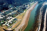
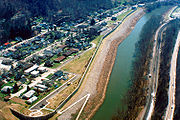
South Williamson is protected by a floodwall, built by the US Army Corps of Engineers in response to a devastating flood along the Tug Fork River in 1977. There have only been two uses of the gates thus far, the first occurred in 2002 during a major flood in the region. And the second occurred in 2003, due to anticipation of the rising river getting higher.
The South Williamson area incorporates the surrounding Kentucky
Kentucky
The Commonwealth of Kentucky is a state located in the East Central United States of America. As classified by the United States Census Bureau, Kentucky is a Southern state, more specifically in the East South Central region. Kentucky is one of four U.S. states constituted as a commonwealth...
communities of Goody, Forest Hills, Toler, and Belfry. In the early 1990s, residents of the area voted down a proposal to incorporate the area. South Williamson is home to the South Side Mall which is the only mall in the area. The zip code of 41503 (South Williamson), and 41527 (Forest Hills) are the 2nd and 3rd (respectively) wealthiest portions of the county. 41503 is the 61st wealthiest in Kentucky and 41527 is the 63rd wealthiest. The average income for these areas are $49,345 (41503), and $48,484 (41527).[6]
Notably, in the late 19th century, Pike County and bordering Mingo County, West Virginia
Mingo County, West Virginia
As of the census of 2000, there were 28,253 people, 11,303 households, and 8,217 families residing in the county. The population density was 67 people per square mile . There were 12,898 housing units at an average density of 30 per square mile...
provided the setting for the Hatfield-McCoy feud
Hatfield-McCoy feud
The Hatfield–McCoy feud involved two families of the West Virginia–Kentucky back country along the Tug Fork, off the Big Sandy River. The Hatfields of West Virginia were led by William Anderson "Devil Anse" Hatfield while the McCoys of Kentucky under the leadership of Randolph "Ole Ran'l" McCoy....
, a bitter feud waged between two feuding families between 1878 and 1891 that has become American History
History
History is the discovery, collection, organization, and presentation of information about past events. History can also mean the period of time after writing was invented. Scholars who write about history are called historians...
.
The local economy is largely fueled by coal mining, transportation, health care, and retail.