

Silver Sands State Park
Encyclopedia
Milford, Connecticut
Milford is a coastal city in southwestern New Haven County, Connecticut, United States, located between Bridgeport and New Haven. The population was 52,759 at the 2010 census...
, USA which offers facilities for swimming in the Long Island Sound
Long Island Sound
Long Island Sound is an estuary of the Atlantic Ocean, located in the United States between Connecticut to the north and Long Island, New York to the south. The mouth of the Connecticut River at Old Saybrook, Connecticut, empties into the sound. On its western end the sound is bounded by the Bronx...
, picnicking, trails, boardwalk
Boardwalk
A boardwalk, in the conventional sense, is a wooden walkway for pedestrians and sometimes vehicles, often found along beaches, but they are also common as paths through wetlands, coastal dunes, and other sensitive environments....
s and opportunities for bird-watching. It includes the 14 acres (56,656 m²) bird sanctuary of Charles Island
Charles Island
Charles Island is a 14 acre island located roughly 0.5 mile off the coast of Milford, Connecticut, in Long Island Sound centered at ....
, which is rumored to be the site of Captain Kidd's buried treasure
Buried treasure
A buried treasure is an important part of the popular beliefs surrounding pirates and Old West outlaws. According to popular conception, criminals and others often buried their stolen fortunes in remote places, intending to return for them later, often with the use of treasure maps.-Pirate...
. Silver Sands is adjacent to the city-owned park, Walnut Beach.
Silver Sands consists of 47 acres (190,202.4 m²) of beach, dunes, restored salt marsh, open areas and woods. The park land was acquired by the state after Hurricane Diane
Hurricane Diane
Hurricane Diane was one of three hurricanes to hit North Carolina during the 1955 Atlantic hurricane season, striking an area that had been hit by Hurricane Connie five days earlier...
destroyed 75 homes there in 1955. The area includes the tidal channels of the Fletcher's Creek and Nettleton Creek watershed and had been a local dumping site and landfill until 1977. Soil analyses have indicated the presence of heavy metal pollutants, probably due to the area's use as a dump.
In 1997, a project to restore the coastal wetlands along Silver Sands was approved.
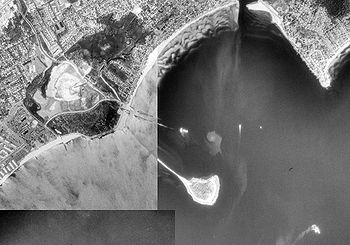
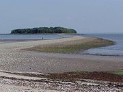
During low tide, you can walk across the tombolo
Tombolo
A tombolo, from the Italian tombolo, derived from the Latin tumulus, meaning 'mound,' and sometimes translated as ayre , is a deposition landform in which an island is attached to the mainland by a narrow piece of land such as a spit or bar. Once attached, the island is then known as a tied island...
to Charles Island. The wooded interior of the island is protected for heron
Heron
The herons are long-legged freshwater and coastal birds in the family Ardeidae. There are 64 recognised species in this family. Some are called "egrets" or "bitterns" instead of "heron"....
and egret
Egret
An egret is any of several herons, most of which are white or buff, and several of which develop fine plumes during the breeding season. Many egrets are members of the genera Egretta or Ardea which contain other species named as herons rather than egrets...
rookeries. It is one of the largest wading bird rookeries in the state. The ruins of a Catholic Retreat from the 1920s remain on the island. A boardwalk with railings extends from the parking lot to the beach (about 200 ft) and also runs along part of the beach. The land alongside the boardwalk had been used as a landfill. However, the salt water tidal marsh is being environmentally restored. Through the marsh, there are also remnants of the foundations of cottages that were destroyed by Diane. There is also an old dirt road that goes east-west through the park.
Many birds can be seen at the park. Least and common terns feed here. It is also a wintering area for raptors
Bird of prey
Birds of prey are birds that hunt for food primarily on the wing, using their keen senses, especially vision. They are defined as birds that primarily hunt vertebrates, including other birds. Their talons and beaks tend to be relatively large, powerful and adapted for tearing and/or piercing flesh....
such as the Rough-legged Hawk, the Snowy owl
Snowy Owl
The Snowy Owl is a large owl of the typical owl family Strigidae. The Snowy Owl was first classified in 1758 by Carolus Linnaeus, the Swedish naturalist who developed binomial nomenclature to classify and organize plants and animals. The bird is also known in North America as the Arctic Owl, Great...
and the Short-eared owl
Short-eared Owl
The Short-eared Owl is a species of typical owl . In Scotland this species of owl is often referred to as a cataface, grass owl or short-horned hootlet. Owls belonging to genus Asio are known as the eared owls, as they have tufts of feathers resembling mammalian ears. These "ear" tufts may or may...
.
Park Hours
Connecticut State Parks are open from 8:00 AM to Sunset. After hours fishing is permitted for anglers who walk in or park in the fisherman's parking lot at the west end of East Broadway where it dead ends at the park.Safety on the Sandbar (Tombolo)
Walking along the sandbar to Charles Island can be dangerous. If you plan to head out to the island, you should start out about one hour before dead-low tide and follow the tide out. Do not attempt to walk to Charles Island after low tide has passed. Many things can affect the tide, including the moon phase, time of year, and weather conditions. There are times that the sandbar will not uncover enough to safely get to the island. If it is not exposed by the time of dead-low tide, it will not uncover and you should never walk along any area of the sandbar that has already flooded. If you venture to the island in the late afternoon, make sure you are back at your vehicle before the park closes at sunset or it may get locked in.If you are unsure if it is safe to walk on the sandbar, check with park staff for information.
Location and Contact Information

Silver Sands State Park
(203) 874-3703
c/o Osbornedale State Park
555 Roosevelt Dr. Derby, CT 06418
(203) 735-4311
Directions
Off I-95: take Exit 35. Follow Schoolhouse Road south to Route 1 (Bridgeport Avenue). Turn left onto Route 1 then right at first light (Silver Sands Park Way). Follow Park Way across Meadowside Road and continue down hill to main parking lot.Pets & Alcohol
- Pets are not permitted on the beach or boardwalk.
- Pets are permitted in all other areas of the park and must be on a leash and under control of the owner at all times.
- Silver Sands is an alcohol-free park. Please do not bring alcoholic beverages.