
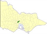
Shire of Kyneton
Encyclopedia
Melbourne
Melbourne is the capital and most populous city in the state of Victoria, and the second most populous city in Australia. The Melbourne City Centre is the hub of the greater metropolitan area and the Census statistical division—of which "Melbourne" is the common name. As of June 2009, the greater...
, the state capital of Victoria
Victoria (Australia)
Victoria is the second most populous state in Australia. Geographically the smallest mainland state, Victoria is bordered by New South Wales, South Australia, and Tasmania on Boundary Islet to the north, west and south respectively....
, Australia
Australia
Australia , officially the Commonwealth of Australia, is a country in the Southern Hemisphere comprising the mainland of the Australian continent, the island of Tasmania, and numerous smaller islands in the Indian and Pacific Oceans. It is the world's sixth-largest country by total area...
. The shire covered an area of 725.2 square kilometres (280 sq mi), and existed from 1859 until 1995.
History
Kyneton was first incorporated as a district on 8 February 1859, and became a shire on 18 January 1865.On 5 February 1913 and 9 October 1921, it gained parts of Shire of Bacchus Marsh
Shire of Bacchus Marsh
The Shire of Bacchus Marsh was a Local Government Area located about west of Melbourne, the state capital of Victoria, Australia. The shire covered an area of , and existed from 1862 until 1994.-History:...
and Shire of Ballan
Shire of Ballan
The Shire of Ballan was a Local Government Area located about west of Melbourne, the state capital of Victoria, Australia. The shire covered an area of , and existed from 1862 until 1994.-History:...
respectively, while on 1 October 1915, it absorbed the Borough of Malmsbury, which had been created on 19 October 1861 with an area of 17.05 square kilometres (6.58 sq mi).
On 20 January 1995, the Shire was abolished, and merged with the Shires of Gisborne
Shire of Gisborne
The Shire of Gisborne was a Local Government Area located about northwest of Melbourne, the state capital of Victoria, Australia. The shire covered an area of , and existed from 1860 until 1995.-History:...
, Newham and Woodend and Romsey
Shire of Romsey
The Shire of Romsey was a Local Government Area located about north-northwest of Melbourne, the state capital of Victoria, Australia. The shire covered an area of , and existed from 1862 until 1995.-History:...
into the Shire of Macedon Ranges. A small part of the shire also became part of the Hepburn Shire
Hepburn Shire
The Shire of Hepburn is a Local Government Area in Victoria, Australia. It is located in the central part of the state. It includes the towns of Clunes, Creswick, Daylesford, Hepburn Springs and Trentham. It has an area of 1,463 square kilometres. In 2006 it had a population of 13,732...
.
Wards
Kyneton was divided into four ridings , each of which elected three councillors:- Kyneton East Riding
- Kyneton West Riding
- Trentham/Tylden Riding
- Carlsruhe/Malmsbury Riding
Towns and localities
- KynetonKyneton, VictoriaKyneton is a town on the Calder Highway in the Macedon Ranges of Victoria, Australia. The Calder Freeway bypasses Kyneton to the north and east. The town was named after the English village of Kineton, Warwickshire. The town has three main streets: Mollison Street, Piper Street and High Street...
- BayntonBaynton, VictoriaBaynton is a small rural community in central Victoria, Australia. Baynton is located approximately north-east of Kyneton, and north-west of Lancefield. Baynton's elevation varies from 450 to 650 metres above sea level, and rainfall averages per annum. Agriculturally the region produces...
- CarlsruheCarlsruhe, VictoriaCarlsruhe is a small rural town in the Shire of Macedon Ranges between Woodend and Kyneton, alongside the old Calder Highway, although now bypassed bypassed by the Calder Freeway. It is approximately 50 minutes from both Melbourne and Bendigo...
- East Trentham
- Edgecombe
- Fern Hill
- Green Hill
- LauristonLauriston, VictoriaLauriston is a small community in Victoria, Australia. It is situated on the Coliban River, in a gully west of Kyneton. The Lauriston Reservoir, , is south east of the town.At the 2006 Census, Lauriston had a population of 538....
- MalmsburyMalmsbury, VictoriaMalmsbury is a town in central Victoria, Australia. It lies on the Old Calder Highway , 96 km north west of the state capital, Melbourne and 11 km north west of Kyneton. Situated close by the Coliban River, Malmsbury has a population of 587...
- Newbury
- Pastoria
- Pastoria East
- Piper's Creek
- Sidonia
- Spring Hill
- TrenthamTrentham, VictoriaTrentham is a small town in the Shire of Hepburn and Shire of Moorabool Local government area, Victoria, Australia. At the 2006 census, Trentham had a population of 629.Located at an altitude of , the town is north-west of Melbourne.-History:...
- TyldenTylden, VictoriaTylden is a small country town in central Victoria, Australia. The town is located in the Shire of Macedon Ranges Local Government Area, north west of the state capital, Melbourne. At the 2006 census, Tylden has a population of 350.-Today:...
Population
| Year | Population |
|---|---|
| 1954 | 6,063 |
| 1958 | 6,340* |
| 1961 | 5,979 |
| 1966 | 5,967 |
| 1971 | 5,959 |
| 1976 | 6,293 |
| 1981 | 6,748 |
| 1986 | 7,657 |
| 1991 | 8,387 |
* Estimate in the 1958 Victorian Year Book.