
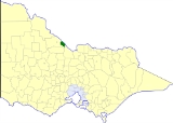
Shire of Cohuna
Encyclopedia
Murray River
The Murray River is Australia's longest river. At in length, the Murray rises in the Australian Alps, draining the western side of Australia's highest mountains and, for most of its length, meanders across Australia's inland plains, forming the border between New South Wales and Victoria as it...
about 265 kilometres (165 mi) north-northwest of Melbourne
Melbourne
Melbourne is the capital and most populous city in the state of Victoria, and the second most populous city in Australia. The Melbourne City Centre is the hub of the greater metropolitan area and the Census statistical division—of which "Melbourne" is the common name. As of June 2009, the greater...
, the state capital of Victoria
Victoria (Australia)
Victoria is the second most populous state in Australia. Geographically the smallest mainland state, Victoria is bordered by New South Wales, South Australia, and Tasmania on Boundary Islet to the north, west and south respectively....
, Australia
Australia
Australia , officially the Commonwealth of Australia, is a country in the Southern Hemisphere comprising the mainland of the Australian continent, the island of Tasmania, and numerous smaller islands in the Indian and Pacific Oceans. It is the world's sixth-largest country by total area...
. The shire covered an area of 494.69 square kilometres (191 sq mi), and existed from 1922 until 1994.
History
Cohuna was originally part of the Swan Hill District, which initially covered most of northwestern Victoria. Swan Hill was incorporated on 8 July 1862, and became a shire on 14 August 1871. It was renamed Shire of KerangShire of Kerang
The Shire of Kerang was a Local Government Area located in northwestern Victoria, Australia, along the Murray River. The shire covered an area of , and existed from 1862 until 1995. From 1966 onwards Kerang itself was managed by a separate entity, the Borough of Kerang...
on 31 December 1898.
On 8 March 1922, parts of the North East and South East Ridings severed and incorporated as the Shire of Cohuna.
On 20 January 1995, the Shire was abolished, and merged with the Borough
Borough of Kerang
The Borough of Kerang was a Local Government Area located in northwestern Victoria, Australia. The borough, for most of its history part of the surrounding Shire of Kerang, covered an area of , and existed from 1966 until 1995.-History:...
and Shire of Kerang
Shire of Kerang
The Shire of Kerang was a Local Government Area located in northwestern Victoria, Australia, along the Murray River. The shire covered an area of , and existed from 1862 until 1995. From 1966 onwards Kerang itself was managed by a separate entity, the Borough of Kerang...
into the Shire of Gannawarra.
Wards
Cohuna was divided into three wards, each of which elected three councillors:- Central Ward
- East Ward
- West Ward
Towns and localities
- CohunaCohuna, VictoriaCohuna is a town situated north of Melbourne, on the Murray Valley Highway, in northern Victoria, Australia. At the 2006 census, Cohuna had a population of 1,893.-History:...
- Gannawarra
- GunbowerGunbower, VictoriaGunbower is a town in northern Victoria, Australia. The town is located in the Shire of Campaspe, north of the state capital, Melbourne on the banks of Gunbower Creek...
- LeitchvilleLeitchville, VictoriaLeitchville is a town in northern Victoria, Australia. The town is located in the Shire of Gannawarra Local Government Area, 262 kilometres of the state capital, Melbourne...
- Mead
- McMillans
Population
| Year | Population |
|---|---|
| 1954 | 3,872 |
| 1958 | 4,190* |
| 1961 | 4,435 |
| 1966 | 4,664 |
| 1971 | 4,768 |
| 1976 | 4,607 |
| 1981 | 4,505 |
| 1986 | 4,332 |
| 1991 | 4,312 |
* Estimate in the 1958 Victorian Year Book.