
Shielmartin Hill
Encyclopedia
Shielmartin Hill or Shelmartin (163 metres (535 ft) high) is a peak on Howth Head
. From it can be seen Portmarnock
, Sutton
, Bull Island
and the coastal areas behind it, and most of Dublin Bay
.
, on whose southern edge three or four modern cairns in the form of circles have been built. The original cairn may be the burial site of Crimhthan Niadhnair
.
The hill is surrounded by Howth Golf Course to the west, north and east. To the southwest it is bordered by Carrickbrack Road
, from which a path leads up to the top. Private residences lie to the south.
, the highest point of Howth peninsula, which lies approximately 1 kilometre (0.621372736649807 mi) to the east. Also adjacent is Dun Hill, while nearby are Muck Rock (Carrickmore) and Carrickbrack.
Howth Head
Howth Head is a headland north east of Dublin City in Ireland. Howth falls under the local governance of fingal county council. Entry to the headland is at Sutton while village of Howth and the harbour are on the northern shore. Baily Lighthouse is on the southeastern part of Howth Head...
. From it can be seen Portmarnock
Portmarnock
Portmarnock is a small suburban village to the north of Dublin, Ireland. It is in the administrative county of Fingal.-Location:Portmarnock lies on the coast and, owing to its proximity to Dublin city, is a form of dormitory village north-northeast of the city centre...
, Sutton
Sutton, Dublin
Sutton is a residential suburb of Dublin's Northside, Ireland, at the base of Howth Head, the peninsula which forms the northern edge of Dublin Bay.-Location and geography:...
, Bull Island
Bull Island
Bull Island or more properly North Bull Island is an island located in Dublin Bay in Ireland, about 5 km long and 800 m wide, lying roughly parallel to the shore off Clontarf , Raheny, Kilbarrack, and facing Sutton...
and the coastal areas behind it, and most of Dublin Bay
Dublin Bay
Dublin Bay is a C-shaped inlet of the Irish Sea on the east coast of Ireland. The bay is about 10 kilometres wide along its north-south base, and 7 km in length to its apex at the centre of the city of Dublin; stretching from Howth Head in the north to Dalkey Point in the south...
.
Form
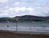
From Sutton Creek, the crest of the hill seems to be cleft in two, but the actual peak is the southern one (i.e. the one to the right in the picture) - the northern one is an ancient cairnCairn
Cairn is a term used mainly in the English-speaking world for a man-made pile of stones. It comes from the or . Cairns are found all over the world in uplands, on moorland, on mountaintops, near waterways and on sea cliffs, and also in barren desert and tundra areas...
, on whose southern edge three or four modern cairns in the form of circles have been built. The original cairn may be the burial site of Crimhthan Niadhnair
Crimthann Nia Náir
Crimthann Nia Náir , son of Lugaid Riab nDerg, was, according to medieval Irish legend and historical tradition, a High King of Ireland...
.
Access
A sign engraved on a stone slab indicates that the only right of way lies down the northwest side of the hill. Other paths exist, but the one to the northeast is dangerous as it is both extremely steep and overgrown. A route to the southeast is safe, but leads across the golf course.The hill is surrounded by Howth Golf Course to the west, north and east. To the southwest it is bordered by Carrickbrack Road
Carrickbrack Road
Carrickbrack Road is a road in Dublin, Ireland. It leads east-southeast from Sutton Creek around the southern part of Howth Head up to the eastern part of the headland near the summit to Thormanby Road. It is the main thoroughfare through the southern part of the headland. Greenfield Road links it...
, from which a path leads up to the top. Private residences lie to the south.
Other peaks
The hill is sometimes confused with the Black Linn at the Ben of HowthBen of Howth
The Ben of Howth is a hilly area on Howth Head, adjacent to the 171 metre high Black Linn, the peninsula's highest point. Lying approximately 1½ km to the south of Howth village, the nearest road is Windgate Road, from which a path leads west past Green Hallows quarry.Two of Howth's...
, the highest point of Howth peninsula, which lies approximately 1 kilometre (0.621372736649807 mi) to the east. Also adjacent is Dun Hill, while nearby are Muck Rock (Carrickmore) and Carrickbrack.