

Sherwood Island State Park
Encyclopedia
Long Island Sound
Long Island Sound is an estuary of the Atlantic Ocean, located in the United States between Connecticut to the north and Long Island, New York to the south. The mouth of the Connecticut River at Old Saybrook, Connecticut, empties into the sound. On its western end the sound is bounded by the Bronx...
, in the Greens Farms section of Westport, Connecticut
Westport, Connecticut
-Neighborhoods:* Saugatuck – around the Westport railroad station near the southwestern corner of the town – a built-up area with some restaurants, stores and offices....
.
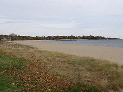
It covers 234 acre (0.94696524 km²) of beach
Beach
A beach is a geological landform along the shoreline of an ocean, sea, lake or river. It usually consists of loose particles which are often composed of rock, such as sand, gravel, shingle, pebbles or cobblestones...
, wetlands and woodland
Woodland
Ecologically, a woodland is a low-density forest forming open habitats with plenty of sunlight and limited shade. Woodlands may support an understory of shrubs and herbaceous plants including grasses. Woodland may form a transition to shrubland under drier conditions or during early stages of...
s. People come to the park to enjoy various outdoor sports, study nature, fly kites or model airplanes, picnic, or just relax under the trees.
The park is bounded on the west by the Sherwood Mill Pond, and on the south by the Sound, but it is separated from the mainland only by creeks and ditches. Access is by road: the Sherwood Island Connector that intersects with Interstate 95
Interstate 95 in Connecticut
Interstate 95, the main north–south Interstate Highway on the East Coast of the United States, runs in a general east–west compass direction for 111.57 miles in Connecticut from the Rhode Island state line to the New York State line. I-95 Southbound from East Lyme to the New York State...
.
Waves on the beach separate three different colors of sand into different lines—red (garnet
Garnet
The garnet group includes a group of minerals that have been used since the Bronze Age as gemstones and abrasives. The name "garnet" may come from either the Middle English word gernet meaning 'dark red', or the Latin granatus , possibly a reference to the Punica granatum , a plant with red seeds...
), black (magnetite
Magnetite
Magnetite is a ferrimagnetic mineral with chemical formula Fe3O4, one of several iron oxides and a member of the spinel group. The chemical IUPAC name is iron oxide and the common chemical name is ferrous-ferric oxide. The formula for magnetite may also be written as FeO·Fe2O3, which is one part...
) and white (quartz
Quartz
Quartz is the second-most-abundant mineral in the Earth's continental crust, after feldspar. It is made up of a continuous framework of SiO4 silicon–oxygen tetrahedra, with each oxygen being shared between two tetrahedra, giving an overall formula SiO2. There are many different varieties of quartz,...
) are sorted by the waves because each type has a different density and shape from the others.
Before the park
In the 1640s, several colonists who came to be known as the"Bankside Farmers
Bankside Farmers
The Bankside Farmers were a group of five men who established themselves along the Long Island Sound south of Fairfield, Connecticut in 1648. The area is now known as Greens Farms, a section of Westport, Connecticut....
" from the Town of Fairfield
Fairfield, Connecticut
Fairfield is a town located in Fairfield County, Connecticut, United States. It is bordered by the towns of Bridgeport, Trumbull, Easton, Redding and Westport along the Gold Coast of Connecticut. As of the 2010 census, the town had a population of 59,404...
settled in the area that included Fox Island, administering the island in common.
Daniel Sherwood, settled on Fox Island in 1787. During the 1800s, his large family farmed the uplands on the west side of the island and operated a gristmill on the Mill Pond. Many farmers shared the Machamux salt marsh. (See also Henry Burr Sherwood
Henry Burr Sherwood
Henry Burr Sherwood was an inventor, miller, and farmer in Westport, Connecticut.He played a notable role in the 19th century economy of the Westport Connecticut area, including owning & operating the Compo Tide Mill , inventing a farming implement important for...
). By the 1860s, the place was known as "Sherwood's Island". Gallup Gap Creek at one time ran north and south on the east side of the park but not far from the center. Some have said that what was known previously as Sherwood's Island was only west of that creek, which was later dammed up to help water flow at the grist mill.
The park
When the Connecticut State Park Commission was formed in 1911, one of its main tasks was to find and develop shore parks along Connecticut's coastline. Field secretary Albert Turner walked the shoreline seeking suitable sites: several hundred acres of undeveloped land with natural scenic beauty, fronting on a good beach, and far enough from cities to ensure freedom from sewage pollution and lack of interference with industrial development. He concluded that Sherwood Island was the only suitable site in Fairfield County.At that time, the land had many owners. Acting for the state, Westport farmer and public citizen William H. Burr Jr., who led the fight to create the park, bought two small parcels in 1914, including a 5 acres (20,234.3 m²) strip of beachfront, giving Sherwood Island its designation as Connecticut’s first state park, although it took another two decades for the park to be widely used. Various parcels bought by 1915 amounted to 24 acres (97,124.6 m²) by deed, although a state survey showed they in fact amounted to 30 acres (121,405.8 m²). The park at this point had 23350 feet (7,117.1 m) of shorefront.
In 1923 another 18 acres (72,843.5 m²) north of the island were acquired for possible use as a parking lot, although they were unconnected to the other 30 acres (121,405.8 m²). Some access to the park at this time was available through the Town of Westport's Burying Hill Beach. At this point, further development of the park stalled when local landowners, led by local property owner Edward Gair, persuaded a town meeting to oppose further land acquisitions and spending on the park. The state legislature, reluctant to act without local approval, defeated a proposal from the State Parks Commission to spend $500,000 on further park development. Large beachfront properties were acquired by developers. For the next nine years, supporters and opponents in Westport and Fairfield County debated the matter. By 1932, the state leased more land in what became the park (with an option to buy within five years) and opened the park that summer.
On April 29, 1937, with the lease and option to buy nearing expiration, Governor Wilbur L. Cross signed two bills with a total appropriation of $485,000 for the state to buy more land and develop the park. This was a victory for Connecticut Forestry Association and the Fairfield County Planning Association, and supporters including William H. Burr, who came to be known as the father of the park.
In the 1950s, the U.S. Army Corps of Engineers constructed jetties and extended the two beaches. The park's beaches are 6000 feet (1,828.8 m) long, more than a mile.
9-11 Memorial
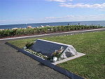
Connecticut's 9-11 Living Memorial.