

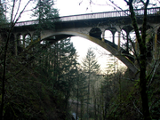
Shepperd's Dell
Encyclopedia
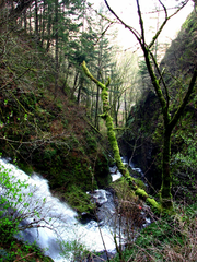
Columbia River Gorge
The Columbia River Gorge is a canyon of the Columbia River in the Pacific Northwest of the United States. Up to deep, the canyon stretches for over as the river winds westward through the Cascade Range forming the boundary between the State of Washington to the north and Oregon to the south...
in Oregon
Oregon
Oregon is a state in the Pacific Northwest region of the United States. It is located on the Pacific coast, with Washington to the north, California to the south, Nevada on the southeast and Idaho to the east. The Columbia and Snake rivers delineate much of Oregon's northern and eastern...
, located at 45.54833°N 122.195°W
which is less than one-third mile (500 m) southeast of Rooster Rock
Rooster Rock
Rooster Rock State Park is a state park located east of Corbett, in the U.S. state of Oregon. One of the features of the park is Rooster Rock, a column of basalt forming a natural obelisk, which stands near the south side of the Columbia River Gorge, in the lee of Crown Point...
State Park.
The spelling of the dell's name tends to vary depending on the source. The official Oregon State Park site http://www.oregonstateparks.org/park_168.php spells it with the apostrophe, however the GNIS entry omits the apostrophe.