

Sgurr nan Eugallt
Encyclopedia
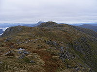
Sgurr nan Eugallt is the highest of a well defined group of mountains that lie south of Loch Hourn
, stretching from Barrisdale to Loch Quoich
. Although its summit is lower than many nearby neighbours, it is cut off from all its higher neighbours by a ring of deep glens. Despite being in a very wild and remote area, it can be easily ascended from a ruined roadside cottage 4 km to the east of its summit, where there is limited parking space. But the road is single track and the cottage is 20 miles from the nearest main road. Due to its isolation and insufficient height to qualify for Munro's Tables
, Sgurr nan Eugallt is infrequently climbed.
 An old stalkers' path from the ruined cottage should guide the climber to a point just below a ridge at about 650 metres. The path was well built in its time but some sections have become wet and slippery. On gaining the ridge, turn left and follow the ridge to the 894 m triangulation point. The ridge becomes steep near the top but the steepest section can be bypassed. Contrary to the implication of the 1:50,000 Landranger map, several websites and the 1990 edition of the Scottish Mountaineering Club
publication The Corbetts and other Scottish Hills, the true summit lies about 600 metres to the north west of the triangulation point. List tickers should therefore turn right along the main ridge of the range and continue for about 600 metres to the main summit, which is not shown on any map. About 300 m further along the ridge is an 881 m summit, which is shown on topographic maps.
Loch Hourn
Loch Hourn is a sea loch to the north of Knoydart, on the west coast of Scotland.-Geography:Loch Hourn runs inland from the Sound of Sleat, opposite the island of Skye, for 22 km to the head of the loch at Kinloch Hourn...
, stretching from Barrisdale to Loch Quoich
Loch Quoich
Loch Quoich is a loch and reservoir situated west of Loch Garry approximately 40k m northwest of Fort William, Lochaber, Scotland...
. Although its summit is lower than many nearby neighbours, it is cut off from all its higher neighbours by a ring of deep glens. Despite being in a very wild and remote area, it can be easily ascended from a ruined roadside cottage 4 km to the east of its summit, where there is limited parking space. But the road is single track and the cottage is 20 miles from the nearest main road. Due to its isolation and insufficient height to qualify for Munro's Tables
Munro
A Munro is a mountain in Scotland with a height over . They are named after Sir Hugh Munro, 4th Baronet , who produced the first list of such hills, known as Munros Tables, in 1891. A Munro top is a summit over 3,000 ft which is not regarded as a separate mountain...
, Sgurr nan Eugallt is infrequently climbed.
Ascents
Scottish Mountaineering Club
The Scottish Mountaineering Club is Scotland's second oldest mountaineering club. Founded in 1889, in Glasgow, the private club, with about 400 members, publishes guidebooks and runs a list of Munroists.-History:At the time of the club's founding there were a number of experienced Alpinists...
publication The Corbetts and other Scottish Hills, the true summit lies about 600 metres to the north west of the triangulation point. List tickers should therefore turn right along the main ridge of the range and continue for about 600 metres to the main summit, which is not shown on any map. About 300 m further along the ridge is an 881 m summit, which is shown on topographic maps.