
Sgurr Ghiubhsachain
Encyclopedia
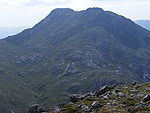
Sgurr Ghiubhsachain is a the mountain in the Lochaber
area in the west of Scotland
. Its summit is the highest point in a group of mountains that stand south of Glenfinnan
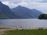
, to the south east of the northern part of Loch Shiel
. It is considerably lower than the nearby Nevis
range, but it is a long way from a public road. Its slopes are steep and rugged on all sides and are devoid of paths. Despite easy access to the trail head from the road from Fort William
to Mallaig
, an individual or party that climbs this mountain may be alone there, even on a fine day in the summer.
in places. The guidebooks recommend bypassing the lower part of the ridge via the Allt Coire Ghiubhsachain, but not all authorities agree that this is necessary. After gaining a subsidiary summit at an elevation of about 820 metres, the route continues along a short ridge via a minor col to the main summit, which is marked by a large cairn.
If returning by the Allt na Cruaiche route (see below), a direct descent of the south east face may be obstructed by steep slabs, but these can be avoided by first returning to the minor col.
populations, and at the time of writing (June 2008), some of the lower part had been bulldozed away to construct a service road for a new hydro-electric development. From the high point of the path, the route traverses up to the 600m col to the north east of Sgurr Ghiubhsachain; from the col, the route to the minor col between the main and subsidiary summits avoids the steep slabs.
 Corbett and Marilyn baggers
can include Sgorr Croabh a Chaorainn (rowantree peak), to the north east of the above mentioned 600m col, within their itinerary. A crossing of this peak provides a good alternative to part of the Cruaiche path. There are steep sections that may require scrambling; a step to the west of the summit can be bypassed on the south side.
Lochaber
District of Lochaber 1975 to 1996Highland council area shown as one of the council areas of ScotlandLochaber is one of the 16 ward management areas of the Highland Council of Scotland and one of eight former local government districts of the two-tier Highland region...
area in the west of Scotland
Scotland
Scotland is a country that is part of the United Kingdom. Occupying the northern third of the island of Great Britain, it shares a border with England to the south and is bounded by the North Sea to the east, the Atlantic Ocean to the north and west, and the North Channel and Irish Sea to the...
. Its summit is the highest point in a group of mountains that stand south of Glenfinnan
Glenfinnan
Glenfinnan is a village in Lochaber area of the Highlands of Scotland. It is located at the northern end of Loch Shiel, at the foot of Glenfinnan.- Glenfinnan Monument :...
, to the south east of the northern part of Loch Shiel
Loch Shiel
Loch Shiel is a 19.3 km2 freshwater loch, 120 m deep, situated 20 km west of Fort William in Lochaber, Highland, Scotland...
. It is considerably lower than the nearby Nevis
Ben Nevis
Ben Nevis is the highest mountain in the British Isles. It is located at the western end of the Grampian Mountains in the Lochaber area of the Scottish Highlands, close to the town of Fort William....
range, but it is a long way from a public road. Its slopes are steep and rugged on all sides and are devoid of paths. Despite easy access to the trail head from the road from Fort William
Fort William, Scotland
Fort William is the second largest settlement in the highlands of Scotland and the largest town: only the city of Inverness is larger.Fort William is a major tourist centre with Glen Coe just to the south, Aonach Mòr to the north and Glenfinnan to the west, on the Road to the Isles...
to Mallaig
Mallaig
Mallaig ; is a port in Lochaber, on the west coast of the Highlands of Scotland. The local railway station, Mallaig, is the terminus of the West Highland railway line , completed in 1901, and the town is linked to Fort William by the A830 road – the "Road to the Isles".The village of Mallaig...
, an individual or party that climbs this mountain may be alone there, even on a fine day in the summer.
Ascents
The best starting point is a car park at Callop, which is close to the A830 road which connects Fort William and Mallaig. From here, there are two possible routes, via the banks of Loch Shiel, or via the Allt na Cruaiche.Loch Shiel Route
From Callop, a forestry vehicle track heads westwards, then continues south west along the banks of Loch Shiel. Those returning by the same route can save time by using a bicycle. After about 6 km, this track reaches a small cottage at Guesachan, from where the north ridge can be ascended. The ridge is steep and craggy, and may require scramblingScrambling
Scrambling is a method of ascending rocky faces and ridges. It is an ambiguous term that lies somewhere between hillwalking and rock climbing. It is often distinguished from hillwalking by defining a scramble as a route where hands must be used in the ascent...
in places. The guidebooks recommend bypassing the lower part of the ridge via the Allt Coire Ghiubhsachain, but not all authorities agree that this is necessary. After gaining a subsidiary summit at an elevation of about 820 metres, the route continues along a short ridge via a minor col to the main summit, which is marked by a large cairn.
If returning by the Allt na Cruaiche route (see below), a direct descent of the south east face may be obstructed by steep slabs, but these can be avoided by first returning to the minor col.
Allt na Cruaiche route
From Callop, a path follows a course west of the Allt na Cruaiche, eventually reaching an elevation of 400 metres before descending into Cona Glen. The path is not in good condition; parts of it are boggy enough to support tadpoleTadpole
A tadpole or polliwog is the wholly aquatic larval stage in the life cycle of an amphibian, particularly that of a frog or toad.- Appellation :...
populations, and at the time of writing (June 2008), some of the lower part had been bulldozed away to construct a service road for a new hydro-electric development. From the high point of the path, the route traverses up to the 600m col to the north east of Sgurr Ghiubhsachain; from the col, the route to the minor col between the main and subsidiary summits avoids the steep slabs.
Sgorr Craobh a'Chaorainn
Peak bagging
Peak bagging is an activity in which hillwalkers and mountaineers attempt to reach the summit of some collection of peaks, usually those above some height in a particular region, or having a particular feature.Peak bagging can be distinguished from highpointing...
can include Sgorr Croabh a Chaorainn (rowantree peak), to the north east of the above mentioned 600m col, within their itinerary. A crossing of this peak provides a good alternative to part of the Cruaiche path. There are steep sections that may require scrambling; a step to the west of the summit can be bypassed on the south side.