
Sendaido
Encyclopedia
The was a subroute of the Ōshū Kaidō
, one of the Edo Five Routes
of Japan
. It connected the Ōshū Kaidō's terminus in Shirakawa
and Mutsu Province
with Sendai. It was established by Tokugawa Ieyasu
for government officials traveling through the area.
along the Sendaidō are listed below in order and are divided by their modern-day prefecture. The present day municipality is listed afterwards in parentheses. The Matsumaedō
connects the end of the Sendaidō with the northern tip of modern-day Aomori Prefecture
.
Oshu Kaido
The was one of the five routes of the Edo period and it was built to connect Edo with Mutsu Province and the present-day city of Shirakawa, Fukushima Prefecture, Japan...
, one of the Edo Five Routes
Edo Five Routes
The were the five major roads that started at Edo during the Edo period, the most important of which was the Tōkaidō, which linked Edo and Kyoto...
of Japan
Japan
Japan is an island nation in East Asia. Located in the Pacific Ocean, it lies to the east of the Sea of Japan, China, North Korea, South Korea and Russia, stretching from the Sea of Okhotsk in the north to the East China Sea and Taiwan in the south...
. It connected the Ōshū Kaidō's terminus in Shirakawa
Shirakawa, Fukushima
is a city in Fukushima, Japan. It is located in the southern portion of the prefecture.The 2003 estimated population was 48,297 and the density in that year was 410.44 persons per km². The total area was 117.67 km²...
and Mutsu Province
Mutsu Province
was an old province of Japan in the area of Fukushima, Miyagi, Iwate and Aomori prefecture and the municipalities of Kazuno and Kosaka in Akita Prefecture...
with Sendai. It was established by Tokugawa Ieyasu
Tokugawa Ieyasu
was the founder and first shogun of the Tokugawa shogunate of Japan , which ruled from the Battle of Sekigahara in 1600 until the Meiji Restoration in 1868. Ieyasu seized power in 1600, received appointment as shogun in 1603, abdicated from office in 1605, but...
for government officials traveling through the area.
Stations of the Sendaidō
The 41 post stationsShukuba
were post stations during the Edo period in Japan, generally located on one of the Edo Five Routes or one of its sub-routes. They were also called shukueki . These post stations were places where travelers could rest on their journey around the nation...
along the Sendaidō are listed below in order and are divided by their modern-day prefecture. The present day municipality is listed afterwards in parentheses. The Matsumaedō
Matsumaedo
The was a subroute of the Ōshū Kaidō, one of the Edo Five Routes of the Japan. It connected the Sendaidō's terminus at Sendai Castle with the northern tip of modern-day Aomori Prefecture. It was established by Tokugawa Ieyasu for government officials traveling through the area...
connects the end of the Sendaidō with the northern tip of modern-day Aomori Prefecture
Aomori Prefecture
is a prefecture of Japan located in the Tōhoku Region. The capital is the city of Aomori.- History :Until the Meiji Restoration, the area of Aomori prefecture was known as Mutsu Province....
.
Fukushima Prefecture
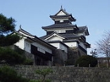
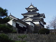
- Starting Location: Shirakawa CastleKomine Castleis a castle in the city of Shirakawa, Fukushima, Japan. It may be also called simply by the name of .In English, its literal meaning could be translated as "Small Peak Castle"...
(白河城) (ShirakawaShirakawa, Fukushimais a city in Fukushima, Japan. It is located in the southern portion of the prefecture.The 2003 estimated population was 48,297 and the density in that year was 410.44 persons per km². The total area was 117.67 km²...
) - 1. Neda-juku (根田宿) (Shirakawa)
- 2. Kotagawa-juku (小田川宿) (Shirakawa)
- 3. Ōtagawa-juku (太田川宿) (IzumizakiIzumizaki, Fukushimais a village located in Nishishirakawa District, Fukushima, Japan.As of 2003, the village has an estimated population of 6,880 and a density of 194.35 persons per km². The total area is 35.40 km².-External links:*...
, Nishishirakawa DistrictNishishirakawa District, Fukushimais a district located in Fukushima, Japan.As of 2003, the district has an estimated population of 68,450 and a density of 138.39 persons per km². The total area is 494.63 km².-Towns and villages:*Izumizaki*Nakajima*Nishigō*Yabuki-Merger:...
) - 4. Fumase-juku (踏瀬宿) (Izumizaki, Nishishirakawa District)
- 5. Yamatoku-juku (大和久宿) (YabukiYabuki, Fukushimais a town located in Nishishirakawa District, Fukushima, Japan.As of 2003, the town has an estimated population of 18,808 and a density of 311.55 persons per km²...
, Nishishirakawa District) - 6. Nakahatashinden-juku (中畑新田宿) (Yabuki, Nishishirakawa District)
- 7. Yabuki-juku (矢吹宿) (Yabuki, Nishishirakawa District)
- 8. Kyūraishi-juku (久来石宿) (KagamiishiKagamiishi, Fukushimais a town located in Iwase District, Fukushima, Japan.As of 2003, the town has an estimated population of 12,718 and a density of 406.98 persons per km². The total area is 31.25 km².-External links:*...
, Iwase DistrictIwase District, Fukushimais a district located in Fukushima, Japan.As of 2003, the district has an estimated population of 31,847 and a density of 83.50 persons per km². The total area is 381.38 km².-Merger:...
) - 9. Kasaishi-juku (笠石宿) (Kagamiishi, Iwase District)
- 10. Sukagawa-juku (須賀川宿) (SukagawaSukagawa, Fukushimais a city located in the center of Fukushima, Japan. It is famous for both its peony garden , a national scenic beauty, and its torch festival which has been hereditary for over 400 years....
) - 11. Sasagawa-juku (笹川宿) (KōriyamaKoriyama, Fukushimais a city in the center of the Nakadōri region of Fukushima Prefecture, Japan. As of May 2011, the city had an estimated population of 336,328. The total area is 757 km²....
) - 12. Hinodeyama-juku (日出山宿) (Kōriyama)
- 13. Koharada-juku (小原田宿) (Kōriyama)
- 14. Kōriyama-juku (郡山宿) (Kōriyama)
- 15. Fukuhara-juku (福原宿) (Kōriyama)
- 16. Hiwada-juku (日和田宿) (Kōriyama)
- 17. Takakura-juku (高倉宿) (Kōriyama)
- 18. Motomiya-juku (本宮宿) (MotomiyaMotomiya, Fukushimawas a town located in the Nakadori, or Abukuma, part of Adachi District, Fukushima, Japan.On January 1, 2007, Motomiya was merged with the village of Shirasawa, also from Adachi District, to form the new city of Motomiya....
)
- 19. Minamisugita-juku (南杉田宿) (NihonmatsuNihonmatsu, Fukushimais a city located in Fukushima, Japan. As of May 2011, the city has an estimated population of 59,323. The total area is 344.65 km².The city was founded on October 1, 1958.-Geography:Nihonmatsu's Western border consists of the Adatara mountain range...
) - 20. Kitasugita-juku (北杉田宿) (Nihonmatsu)
- 21. Nihonmatsu-juku (二本松宿) (Nihonmatsu)
- 22. Nihonyanagi-juku (二本柳宿) (Nihonmatsu)
- 23. Hatchōme-juku (八丁目宿) (FukushimaFukushima, Fukushimais the capital city of Fukushima Prefecture in the Tōhoku Region of Japan. As of May 2011 the city has an estimated population of 290,064 and an area of 746.43 km².It lies about 250 km north of Tokyo and 80 km south of Sendai.-History:...
)- Asakawashinden-juku(浅川新町宿) (Fukushima) (ai no shukuAi no shukuwere unofficial post stations along historical routes in Japan. These post stations formed organically along routes when the distance between two places was too far or when there were difficult passes nearby. Because they were not officially designated rest areas, travelers along the roads were...
)
- Asakawashinden-juku(浅川新町宿) (Fukushima) (ai no shuku
- 24. Shimizuchō-juku (清水町宿) (Fukushima)
- 25. Fukushima-juku (福島宿) (Fukushima)
- 26. Senoue-juku (瀬上宿) (Fukushima)
- 27. Kōri-juku (桑折宿) (KōriKori, Fukushimais a town located in Date District, Fukushima, Japan. It is also known as Koori-machi.As of 2003, the town has an estimated population of 13,507 and a density of 314.34 persons per km². The total area is 42.97 km²....
, Date DistrictDate District, Fukushimais a district located in Fukushima, Japan.As of 2008, the district has an estimated population of 39,633 and a density of 190 persons per km². The total area is 208.53 km².-Towns and villages:*Kawamata*Kōri*Kunimi-Mergers:...
) (also part of the Ushū KaidōUshu KaidoThe was a subroute of the Ōshū Kaidō and the Sendaidō in Japan. It breaks off from the Sendaidō at Kōri-juku in the modern-day Kōri in Fukushima Prefecture. It connects to Aburakawa-juku along Matsumaedō, the other subroute of the Ōshū Kaidō. It is traced by National Routes 13 and 7...
) - 28. Fujita-juku (藤田宿) (KunimiKunimi, Fukushimais a town located in Date District, Fukushima, Japan.As of 2003, the town has an estimated population of 10,889 and a density of 287.31 persons per km². The total area is 37.90 km².-External links:*...
, Date District) - 29. Kaida-juku (貝田宿) (Kunimi, Date District)
Miyagi Prefecture
- 30. Kosugō-juku (越河宿) (ShiroishiShiroishi, Miyagiis a city located in Miyagi Prefecture, Japan.As of 2010, the city has an estimated population of 37,432 and a population density of 131 persons per km². The total area is 286.47 km².The city was founded on April 1, 1954.-Notable locations:...
) - 31. Saikawa-juku (斎川宿) (Shiroishi)
- 32. Shiroishi CastleShiroishi Castleis a Japanese castle in Shiroishi, Miyagi, within what was Mutsu Province. It was the castle of the Katakura clan, which was a family of retainers serving the Date clan of Sendai...
(白石城) (Shiroishi) - 33. Miya-juku (宮宿) (ZaōZao, Miyagiis a town located in Katta District, Miyagi, Japan.As of 2003, the town has an estimated population of 13,360 and a population density of 87.41 persons per km². The total area is 152.85 km².-Major roads:* Tōhoku Expressway:* Route 4, Route 457...
, Katta DistrictKatta District, Miyagiis a district located in Miyagi Prefecture, Japan.As of 2003, the district has an estimated population of 15,266 and a population density of 36.71 persons per km². The total area is 415.85 km²....
) - 34. Kanagase-juku (金ヶ瀬宿) (ŌgawaraOgawara, Miyagiis a town located in Shibata District, Miyagi, Japan.As of 30 September 2011, the town has an estimated population of 23,615. The total area is 25.01 km².-External links:...
, Shibata DistrictShibata District, Miyagiis a district located in Miyagi Prefecture, Japan.As of 2003, the district has an estimated population of 86,405 and a population density of 201.79 persons per km². The total area is 428.20 km².- Towns and villages :*Kawasaki*Murata*Ōgawara*Shibata...
) - 35. Ōgawara-juku (大河原宿) (Ōgawara, Shibata District)
- 36. Funabasama-juku (船迫宿) (Shibata, Shibata District)
- 37. Tsukinoki-juku (槻木宿) (Shibata, Shibata District)
- 38. Iwanuma-juku (岩沼宿) (IwanumaIwanuma, Miyagiis a city located in Miyagi Prefecture, Japan.As of July 1, 2010, the city has an estimated population of 44,379 and a population density of 731 persons per km²...
) - 39. Masuda-juku (増田宿) (NatoriNatori, Miyagiis a city located in Miyagi Prefecture, Japan.As of 2010, the city has an estimated population of 72,757 and a population density of 727 persons per km². The total area is officially 100.07 km²....
) - 40. Nakada-juku (中田宿) (Taihaku-kuTaihaku-ku, Sendaiis a ward located in Sendai in Miyagi, Japan.As of 2005, the ward has an estimated population of 223,530 and the density of 979.49 persons per km²...
, Sendai) - 41. Nagamachi-juku (長町宿) (Taihaku-ku, Sendai)
- Ending Location: Sendai Castle (Aoba-kuAoba-ku, Sendaiis one of five wards of Sendai, the largest city in the Tōhoku region of Japan. Aoba-ku encompasses 302.28 km² and had a population of 282,903 as of August 1, 2005.-Infrastructure:...
, Sendai)