

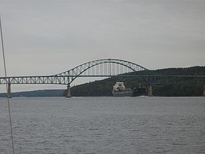
Seal Island Bridge
Encyclopedia
Canada
Canada is a North American country consisting of ten provinces and three territories. Located in the northern part of the continent, it extends from the Atlantic Ocean in the east to the Pacific Ocean in the west, and northward into the Arctic Ocean...
bridge located in Victoria County
Victoria County, Nova Scotia
Victoria County is a county in the Canadian province of Nova Scotia.The shire town and largest municipality is the village of Baddeck.-History:Named after Queen Victoria, it was established by statute in 1851...
, Nova Scotia
Nova Scotia
Nova Scotia is one of Canada's three Maritime provinces and is the most populous province in Atlantic Canada. The name of the province is Latin for "New Scotland," but "Nova Scotia" is the recognized, English-language name of the province. The provincial capital is Halifax. Nova Scotia is the...
.
It is an arch truss
Arch bridge
An arch bridge is a bridge with abutments at each end shaped as a curved arch. Arch bridges work by transferring the weight of the bridge and its loads partially into a horizontal thrust restrained by the abutments at either side...
design and crosses the Great Bras d'Or channel of Bras d'Or Lake
Bras d'Or Lake
Bras d'Or Lake is a large body of salt water dominating the centre of Cape Breton Island in the province of Nova Scotia, Canada. Bras d'Or Lake is sometimes referred to as the Bras d'Or Lakes or the Bras d'Or Lakes system, however its official geographic name is Bras d'Or Lake as it is a singular...
, connecting Boularderie Island
Boularderie Island
Boularderie Island is an island separating the Cabot Strait from Bras d'Or Lake on the eastern coast of Cape Breton Island, Nova Scotia, Canada. It takes its name from Louis-Simon le Poupet de la Boularderie, who was granted the area as a concession from the King of France.At 40 km long and...
on the south side with Cape Breton Island
Cape Breton Island
Cape Breton Island is an island on the Atlantic coast of North America. It likely corresponds to the word Breton, the French demonym for Brittany....
on the north side.
With the third longest bridge span in the province, the Seal Island Bridge opened in 1961 as part of the Trans-Canada Highway
Trans-Canada Highway
The Trans-Canada Highway is a federal-provincial highway system that joins the ten provinces of Canada. It is, along with the Trans-Siberian Highway and Australia's Highway 1, one of the world's longest national highways, with the main route spanning 8,030 km...
project. The structure carries 2 traffic lanes of Highway 105
Nova Scotia Highway 105
Highway 105 in Nova Scotia represents the Cape Breton Island leg of the Trans-Canada Highway. It runs from the junction just east of the Canso Causeway in Port Hastings to the Marine Atlantic ferry terminal in North Sydney, representing a distance of ....
as well as a sidewalk on each side.
The bridge crosses part of the channel on a causeway connecting the north shore of the channel to Seal Island, a small wooded island. It consists of eight steel truss spans: a main arch of 152 m (500 ft), two side spans of 106 m (350 ft), and five approach spans of 76 m (250 ft).
Controversy
The location of the bridge has proven extremely controversial. It replaced two ferryFerry
A ferry is a form of transportation, usually a boat, but sometimes a ship, used to carry primarily passengers, and sometimes vehicles and cargo as well, across a body of water. Most ferries operate on regular, frequent, return services...
services crossing the Great Bras d'Or; one at the northeastern end between New Campbellton
New Campbellton, Nova Scotia
New Campbellton is a small community in the Canadian province of Nova Scotia, located in Victoria County on Cape Breton Island.-References:*...
-Big Bras d'Or
Big Bras d'Or, Nova Scotia
Big Bras d'Or is a small community in the Canadian province of Nova Scotia, located in Victoria County on Cape Breton Island. An important early shipbuilding location, Big Bras d'Or's ships included the ship Inconstant built in 1848, one of the largest ships built in Cape Breton and an important...
, and the other at the southwestern end at Big Harbour
Big Harbour, Nova Scotia
Big Harbour is a small community in the Canadian province of Nova Scotia, located in Victoria County on Cape Breton Island.-References:*...
-Ross Ferry
Ross Ferry, Nova Scotia
Ross Ferry is a small community in the Canadian province of Nova Scotia, located in Victoria County on Cape Breton Island.-References:*...
.
For political reasons, it was decided to place the bridge halfway between the two ferry services on account of an outcry by communities fearing the loss of their transportation links. Unfortunately to do this required a massive modification to the Trans-Canada Highway route on the eastern slope of Kelly's Mountain (240 m (787.4 ft) high), resulting in a 180° "switchback".
A safer alternative to continue the highway further east on a gradual descent of Kelly's Mountain toward New Campbellton, crossing at the northern end of the Great Bras d'Or channel was rejected. Likewise, a route between Beinn Bhreagh
Beinn Bhreagh, Nova Scotia
Beinn Bhreagh, generally pronounced "ban vreeagh", is the name of the estate founded by Dr. Alexander Graham Bell, which has become an unincorporated rural community located in Victoria County, Nova Scotia, Canada...
and Kempt Head
Kempt Head, Nova Scotia
Kempt Head is a small community in the Canadian province of Nova Scotia, located in Victoria County on Boularderie Island.-References:*...
at the extreme southwestern end of the channel (much wider waterway but avoiding Kelly's Mountain altogether) was never considered. Numerous deaths at the switchback have occurred over the years as a result of perceived political interference in choosing the route.