
Saskatchewan Highway 697
Encyclopedia
Saskatchewan Highway 697 connects Saskatchewan Highway 26
in the Meota
rural municipality (RM)
to Saskatchewan Highway 3
in the Parkdale
RM. The length of Highway 697 is 45.4 kilometres (28.2 mi) and extends north, in the north western area of Saskatchewan west of North Battleford
. There are no communities along Highway 697.
(RM) of Meota Number 468
number 468 has a population of 984 residents who are mainly farmers. The retail sector is the next highest employer in this area catering to the tourism sector followed by educational services. Hunting for waterfowl in this region is popular. A Federal Bird Sanctuary was established in the region in 1962 around Scentgrass Lake. Fishing is enjoyed on Jackfish Lake and in the Battlefords Provincial Park which is on the eastern banks of Jackfish Lake. In this region there are erected oil wells in the Meota Lloydminster Sand Pool. The RM is located on a parkland
transition area in Jackfish country. The Local Improvement District was established to monitor civic affairs in 1907. In 1909, the RM of Meota was incorporated. Parkdale Number 98 has a population of 711 residents, with the majority of these employed in the agricultural sector. The next highest employer is education followed by industry. Parkdale RM was established in 1913, preceded by the Local Improvement District which handled civic affairs for three years prior to this. Seasonal visitations increase the population in the resort area of this region. 6 kilometres (3.7 mi) west of Glasylyn is the Little Loon Regional Park in a boreal forest
transition area.
The area belongs to Battlefords Regional Economic Development Authority which has a mandate of creating jobs and employment opportunities in the area enhancing its economic sector.
. To the west along Highway 26 is the town of Vawn
, and to the east along highway 26 is the town of Meota, Saskatchewan
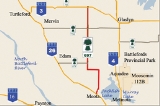
. The beginning terminus circumnavigates around the western shoreline of Jackfish Lake. At Km 11.3, Highway 697 turns west sharply.At Km 16.1, Highway 697 then returns to its northerly routing. At Km 19.3 the Highway meets with the junction with Highway 674
. Highway 674 only extends in a westerly direction providing access to the town of Edam. At Km 35.5, Highway 697 intersects with Highway 794. Travel west on Highway 794 provides access to the town of Mervin, travel east on Highway 794 provides joins Saskatchewan Highway 4
south of the town of Glaslyn
. At Km 45.4, Highway 697 ends at Highway 3
. To the north west of the terminal junction is the town of Livelong
, to the south east along Highway 3 is the town of Glaslyn.
Saskatchewan Highway 26
Highway 26 is a highway in the northern portion of the Canadian province of Saskatchewan and begins at Hwy 4 north of North Battleford which sets the southern end of the highway. The concurrency of Highway 224 east with Highway 950 west separates at Highway 26 which demarks the northern extremity. ...
in the Meota
Meota No. 468, Saskatchewan
Meota No. 468 is a rural municipality in the Canadian province of Saskatchewan. The municipality is located in the Census Division 17 which is a part of SARM Division 6. The seat of the municipality is located in the Village of Meota.-Demographics:...
rural municipality (RM)
Rural municipality
A rural municipality, often abbreviated RM, is a form of municipality in the Canadian provinces of Manitoba and Saskatchewan, perhaps best comparable to counties or townships in the western United States...
to Saskatchewan Highway 3
Saskatchewan Highway 3
Highway 3 is a major provincial paved undivided highway in the Canadian province of Saskatchewan. It runs from the Alberta border, continues west as Alberta Highway 45 to the Manitoba border, and then continues east as Highway 77. Highway 3 is about 615 km long. The CanAm Highway comprises ...
in the Parkdale
Parkdale No. 498, Saskatchewan
Parkdale No. 498 is a rural municipality in the Canadian province of Saskatchewan. The municipality is located in the Census Division 17 which is a part of SARM Division 6. The seat of the municipality is located in the Hamlet of Glaslyn.-Demographics:...
RM. The length of Highway 697 is 45.4 kilometres (28.2 mi) and extends north, in the north western area of Saskatchewan west of North Battleford
North Battleford, Saskatchewan
In the late 2000s a large number of Ruthenians have emigrated to Canada, concentrating in North Battleford.-History:Prior to European settlement, the Battlefords area was home to several aboriginal groups...
. There are no communities along Highway 697.
Rural municipalties
The rural municipalityRural municipality
A rural municipality, often abbreviated RM, is a form of municipality in the Canadian provinces of Manitoba and Saskatchewan, perhaps best comparable to counties or townships in the western United States...
(RM) of Meota Number 468
Meota No. 468, Saskatchewan
Meota No. 468 is a rural municipality in the Canadian province of Saskatchewan. The municipality is located in the Census Division 17 which is a part of SARM Division 6. The seat of the municipality is located in the Village of Meota.-Demographics:...
number 468 has a population of 984 residents who are mainly farmers. The retail sector is the next highest employer in this area catering to the tourism sector followed by educational services. Hunting for waterfowl in this region is popular. A Federal Bird Sanctuary was established in the region in 1962 around Scentgrass Lake. Fishing is enjoyed on Jackfish Lake and in the Battlefords Provincial Park which is on the eastern banks of Jackfish Lake. In this region there are erected oil wells in the Meota Lloydminster Sand Pool. The RM is located on a parkland
Flora of Saskatchewan
The native flora of the Saskatchewan includes vascular plants, plus additional species of other plants and plant-like organisms such as algae, lichens and other fungi, and mosses...
transition area in Jackfish country. The Local Improvement District was established to monitor civic affairs in 1907. In 1909, the RM of Meota was incorporated. Parkdale Number 98 has a population of 711 residents, with the majority of these employed in the agricultural sector. The next highest employer is education followed by industry. Parkdale RM was established in 1913, preceded by the Local Improvement District which handled civic affairs for three years prior to this. Seasonal visitations increase the population in the resort area of this region. 6 kilometres (3.7 mi) west of Glasylyn is the Little Loon Regional Park in a boreal forest
Flora of Saskatchewan
The native flora of the Saskatchewan includes vascular plants, plus additional species of other plants and plant-like organisms such as algae, lichens and other fungi, and mosses...
transition area.
The area belongs to Battlefords Regional Economic Development Authority which has a mandate of creating jobs and employment opportunities in the area enhancing its economic sector.
Travel Route
Highway 697 begins in a northerly direction at the intersection with Highway 26Saskatchewan Highway 26
Highway 26 is a highway in the northern portion of the Canadian province of Saskatchewan and begins at Hwy 4 north of North Battleford which sets the southern end of the highway. The concurrency of Highway 224 east with Highway 950 west separates at Highway 26 which demarks the northern extremity. ...
. To the west along Highway 26 is the town of Vawn
Vawn, Saskatchewan
Vawn, Saskatchewan is a hamlet located on Highway 26....
, and to the east along highway 26 is the town of Meota, Saskatchewan
Meota, Saskatchewan
Meota is a village in Meota Rural Municipality No. 468, Saskatchewan, Canada. The village's population was 297 at the 2006 Canadian Census. The village name is derived from the Cree phrase Meotate or Mo-Was-In-Ota, meaning "good place to camp" or "it is good here."-Demographics:In 2006, Meota had a...
. The beginning terminus circumnavigates around the western shoreline of Jackfish Lake. At Km 11.3, Highway 697 turns west sharply.At Km 16.1, Highway 697 then returns to its northerly routing. At Km 19.3 the Highway meets with the junction with Highway 674
Saskatchewan Highway 674
Highway 674 is a highway in the Canadian province of Saskatchewan. It runs from Highway 40 near Cut Knife to Highway 697. Highway 674 is about 80 km long.Other highways that connect with Highway 674 are Highway 16 and Highway 26...
. Highway 674 only extends in a westerly direction providing access to the town of Edam. At Km 35.5, Highway 697 intersects with Highway 794. Travel west on Highway 794 provides access to the town of Mervin, travel east on Highway 794 provides joins Saskatchewan Highway 4
Saskatchewan Highway 4
Highway 4 is a major highway in the Canadian province of Saskatchewan. It runs from U.S. Route 191 at the United States border near Monchy to Highway 224/Highway 904 at Meadow Lake Provincial Park. Highway 4 is about 653 km long....
south of the town of Glaslyn
Glaslyn, Saskatchewan
- See also :* List of communities in Saskatchewan* Villages of Saskatchewan-External links:*******-Footnotes:...
. At Km 45.4, Highway 697 ends at Highway 3
Saskatchewan Highway 3
Highway 3 is a major provincial paved undivided highway in the Canadian province of Saskatchewan. It runs from the Alberta border, continues west as Alberta Highway 45 to the Manitoba border, and then continues east as Highway 77. Highway 3 is about 615 km long. The CanAm Highway comprises ...
. To the north west of the terminal junction is the town of Livelong
Livelong, Saskatchewan
Livelong is a hamlet in the Canadian province of Saskatchewan. Listed as a designated place by Statistics Canada, the hamlet had a population of 95 in the Canada 2006 Census.S0M 1J0 is a postal code for Livelong....
, to the south east along Highway 3 is the town of Glaslyn.