
Saskatchewan Highway 694
Encyclopedia
Saskatchewan Highway 694 connects Saskatchewan Highway 3
in the Canwood No. 494
rural municipality (RM)
to Saskatchewan Highway 55
at Polwarth. South of Highway 55, Highway 694 is named Hilldrop Road. The length of Highway 694 is 22.9 kilometres (14.2 mi) and extends north, in the north central area of Saskatchewan west of Prince Albert
.
Polwarth is too small to be enumerated on its own, and in the 2006 census it was enumerated as a part of the RM of Canwood. Ahtahkakoop 104 Indian reserve is populated with 1,101 residents.
Thompson from January 1, 1913 to April 29, 1916 before changing names to Canwood No. 494.
and east of Shell Lake
. Highway 694 extends north 22.9 kilometres (14.2 mi) to the Highway 551
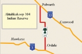
intersection. At Km 2.0 Highway 694 intersects with the range road which provides access to Ordale west of the highway. The highway turns shrpaly to the west at Km 13.2. Continue bearing west until Km 15.3, when the highway returns to the northerly direction. The land area reserved for Indian reserve Ahtahkakoop 104
is west of the highway. Continuing west on the range road will provide a thorouhfare into the Indian reserve. The terminus of Highway 694 is at Polwarth, at the Saskatchewan Highway 55
intersection.
Highway 694 has no intersections with any major road.
Saskatchewan Highway 3
Highway 3 is a major provincial paved undivided highway in the Canadian province of Saskatchewan. It runs from the Alberta border, continues west as Alberta Highway 45 to the Manitoba border, and then continues east as Highway 77. Highway 3 is about 615 km long. The CanAm Highway comprises ...
in the Canwood No. 494
Canwood No. 494, Saskatchewan
The Rural Municipality of Canwood No. 494 was firstly formed as Rural Municipality Thompson No. 494 from January 1, 1913 until April 29, 1916 before changing names to Canwood No. 494. It is located in the north central region of the province of Saskatchewan, west of Prince Albert, and completely...
rural municipality (RM)
Rural municipality
A rural municipality, often abbreviated RM, is a form of municipality in the Canadian provinces of Manitoba and Saskatchewan, perhaps best comparable to counties or townships in the western United States...
to Saskatchewan Highway 55
Saskatchewan Highway 55
Highway 55 is a provincial paved undivided highway in the Canadian province of Saskatchewan. It runs from Alberta Highway 55 near the Alberta border until Highway 9. Highway 55 is 652 km long. It forms part of the interprovincial Northern Woods and Water Route.-Attractions:On the West portion...
at Polwarth. South of Highway 55, Highway 694 is named Hilldrop Road. The length of Highway 694 is 22.9 kilometres (14.2 mi) and extends north, in the north central area of Saskatchewan west of Prince Albert
Prince Albert, Saskatchewan
Prince Albert is the third-largest city in Saskatchewan, Canada. It is situated in the centre of the province on the banks of the North Saskatchewan River. The city is known as the "Gateway to the North" because it is the last major centre along the route to the resources of northern Saskatchewan...
.
Communities
| Communities |
|---|
|
Polwarth is too small to be enumerated on its own, and in the 2006 census it was enumerated as a part of the RM of Canwood. Ahtahkakoop 104 Indian reserve is populated with 1,101 residents.
Rural municipalties
The RM of Canwood has a population of 1,535 residents. Canwood No. 494 was firstly formed as Rural MunicipalityRural municipality
A rural municipality, often abbreviated RM, is a form of municipality in the Canadian provinces of Manitoba and Saskatchewan, perhaps best comparable to counties or townships in the western United States...
Thompson from January 1, 1913 to April 29, 1916 before changing names to Canwood No. 494.
Travel Route
Highway 694 begins west of ShellbrookShellbrook, Saskatchewan
Shellbrook, Saskatchewan is rural community in Saskatchewan, Canada west of Prince AlbertTown, pop 1,276, located 44.5 km W of Prince Albert and served by Hwys 3, 40, and 55.- History :...
and east of Shell Lake
Shell Lake, Saskatchewan
Shell Lake is a village located in the Rural Municipality of Spiritwood No. 496, Saskatchewan. It was formerly part of the Rural Municipality of Shell Lake No. 495, Saskatchewan before it was absorbed in the RM of Spiritwood. The Shell Lake murders took place on a nearby farm....
. Highway 694 extends north 22.9 kilometres (14.2 mi) to the Highway 551
Saskatchewan Highway 55
Highway 55 is a provincial paved undivided highway in the Canadian province of Saskatchewan. It runs from Alberta Highway 55 near the Alberta border until Highway 9. Highway 55 is 652 km long. It forms part of the interprovincial Northern Woods and Water Route.-Attractions:On the West portion...
intersection. At Km 2.0 Highway 694 intersects with the range road which provides access to Ordale west of the highway. The highway turns shrpaly to the west at Km 13.2. Continue bearing west until Km 15.3, when the highway returns to the northerly direction. The land area reserved for Indian reserve Ahtahkakoop 104
Ahtahkakoop 104, Saskatchewan
Ahtahkakoop 104 is an Indian Reserve in Census Division No. 15, Saskatchewan, Canada. It is one of the few settlements in Saskatchewan that is growing in terms of population. Between 2001 and 2006, according to the census, the reserve grew by 0.2%, or 2 people. The current rank of all the...
is west of the highway. Continuing west on the range road will provide a thorouhfare into the Indian reserve. The terminus of Highway 694 is at Polwarth, at the Saskatchewan Highway 55
Saskatchewan Highway 55
Highway 55 is a provincial paved undivided highway in the Canadian province of Saskatchewan. It runs from Alberta Highway 55 near the Alberta border until Highway 9. Highway 55 is 652 km long. It forms part of the interprovincial Northern Woods and Water Route.-Attractions:On the West portion...
intersection.
Highway 694 has no intersections with any major road.