

Ruby Crest National Recreation Trail
Encyclopedia
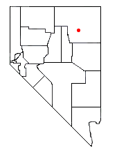
Ruby Mountains
The Ruby Mountains comprise one of the many mountain ranges of the Great Basin in the western United States. They are the predominant range in Elko County, in the northeastern section of the state of Nevada. To the north is Secret Pass and the East Humboldt Range, and from there the Rubies run...
, in Elko County
Elko County, Nevada
-Demographics:As of the census of 2000, there were 45,291 people, 15,638 households, and 11,493 families residing in the county. The population density was 3/sq mi . There were 18,456 housing units at an average density of 1/sq mi...
in the northeastern part of the state of Nevada
Nevada
Nevada is a state in the western, mountain west, and southwestern regions of the United States. With an area of and a population of about 2.7 million, it is the 7th-largest and 35th-most populous state. Over two-thirds of Nevada's people live in the Las Vegas metropolitan area, which contains its...
. Approximately 38 miles (61.2 km) in length, the trail is used by hikers and pack trains to experience some of the most spectacular scenery in the western United States.
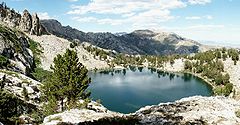
The southern end of the trail is just north of Harrison Pass, at approximately 40°20.2'N and 115°30.1'W and an elevation of 7300 feet (2,225 m). From there it climbs northward around Green and Tipton Peaks, while crossing the three upper forks of Smith Creek. It then climbs steeply to a 10400 feet (3,169.9 m) pass, and descends to scenic Overland Lake.
The next section of trail most closely follows the actual crest of the Rubies, and is therefore the driest. The trail circles around the upper parts of Overland Creek, passes King Peak
King Peak (Nevada)
King Peak is the southernmost summit above in the Ruby Mountains of Elko County, in northeastern Nevada in the western United States. To the west is Rattlesnake Canyon, and to the east is Overland Creek Canyon, which drains into the Ruby Valley). The Ruby Crest National Recreation Trail passes...
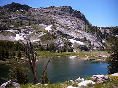
11045 feet (3,366.5 m), climbs to the crest, and then stays above 10000 feet (3,048 m) while passing Long and Mahogany Canyons. After crossing over the top of Wine's Peak 10900 feet (3,322.3 m), it finally descends again into forested areas. A short side trail leads to North Furlong Lake, a common campsite.
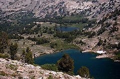
The northern section of the trail includes the most spectacular alpine scenery. The trail drops into Kleckner Canyon (with distant views of Ruby Dome
Ruby Dome
Ruby Dome, the highest peak of the Ruby Mountains and Elko County, is located in northeastern Nevada in the western United States. It rises from a base elevation of about to a height of . It is located about southeast of the city of Elko....
) and crosses Kleckner Creek just below Favre and Castle Lakes. It then climbs to Liberty Lake and Liberty Pass 10400 feet (3,169.9 m). Finally, it descends steeply to Lamoille and Dollar Lakes, and then continues down to the Road's End Trailhead in Lamoille Canyon
Lamoille Canyon
Lamoille Canyon is the largest valley in the Ruby Mountains, located in the central portion of Elko County in the northeastern section of the state of Nevada, in the western United States. Approximately in length, it was extensively sculpted by glaciers in previous ice ages.Lamoille Canyon begins...
, at approximately 40°36.2'N and 115°22.5'W at an elevation of 8800 feet (2,682.2 m).
The USGS 7.5 minute topographic quadrangles that include the length of the trail are: Ruby Dome, Franklin Lake NW, Green Mountain, Harrison Pass, Franklin Lake SW, and Lee.