
.gif)
Route 78 (Rhode Island)
Encyclopedia
Route 78, also known as the Westerly Bypass is a two-lane arterial boulevard and expressway between Stonington, Connecticut
to Westerly, Rhode Island. The route is about 4.4 miles (7.1 km) long and begins at Connecticut Route 2 in Stonington, crossing into Rhode Island at the Pawcatuck River
, where it continues as an expressway to U.S. Route 1
in Westerly. The route was constructed in 1979, after a sixteen year delay. The designation was to become part of the Orient Point–Watch Hill Bridge, but this plan was later dropped. The route was given the memorial name of Veterans Way in 2004.
 Route 78 begins at an interchange with Connecticut Route 2 in Stonington
. The expressway heads eastward, crossing over the Pawcatuck River
and into Rhode Island
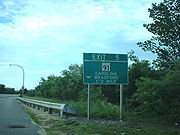
. Route 78 crosses over White Rock Road and Canal Street, entering the community of Stillmanville. There, the highway comes upon a small, partial interchange with High Street, which connects drivers to Rhode Island Route 3. After crossing over Route 3, Route 78 turns to the south. In the opposite direction, where it turns eastward, there is an interchange with Route 3. The route heads southward through the local development, coming to a partial cloverleaf interchange with Rhode Island Route 91 at Exit 5. The route continues southward, passing Chapman Pond and the route becomes an arterial. The route turns southwest, interchanging partially with U.S. Route 1, where the Route 78 designation ends. The right-of-way continues as Airport Road towards Westerly State Airport
.
, and when planned, the route was to exist farther east then it does currently. During the late 1950s, the RIDPW moved the location of the bypass to its current location, creating a 4.8 miles (7.7 km) long bypass of Westerly and connecting with Interstate 95
in Stonington, Connecticut
. The route was proposed to begin at an interchange with U.S. Route 1 near Westerly State Airport
, take an arc expressway and into Connecticut. First estimated to cost $4 million (1959 USD), construction of the new Route 78 Expressway was planned to begin in 1961 and finish in 1963, but lack of funds held off construction for several years.
 In 1967, the state highway officials in Connecticut began to collaborate with Rhode Island officials to construct the new Route 78 Expressway in both states. The plan became detailed as Route 78 would start at US 1 in Rhode Island, continue over the Pawcatuck River
into Connecticut, where it follow Route 2 over to Interstate 95 where it would form an interchange 91A with the interstate. However, this new interchange and extension were pulled by 1971, due to lack of funding. By 1974, the cost had ballooned to $12.8 million (1974 USD) along with a budget crisis around that time, the two states scaled down the project from at an intersection with US 1 to an intersection with CT 2. The bypass was finally constructed in the late 1970s, and opened to traffic in 1979. After a number of head-on collisions, the Rhode Island Department of Transportation added medians to the highway, and in 2004, the bypass was given the memorial name of Veterans Way, which was proposed in 2002.
In 1961, during the time of the proposals, the New York State Department of Transportation
to extend of the Long Island Expressway another 55 miles (88.5 km) further from Riverhead, New York to Westerly, Rhode Island using a multi-span bridge across the Long Island Sound
. The bridge was to extend from Orient Point, New York to Watch Hill, Rhode Island, and although it was never added to the interstate highway plans, the theory of a new bridge was restarted in 1979, with a feasibility study. However, officials from Rhode Island and New York were both uninterested from continuing the project.
Stonington, Connecticut
The Town of Stonington is located in New London County, Connecticut, in the state's southeastern corner. It includes the borough of Stonington, the villages of Pawcatuck, Lords Point, Wequetequock, the eastern halves of the villages of Mystic and Old Mystic...
to Westerly, Rhode Island. The route is about 4.4 miles (7.1 km) long and begins at Connecticut Route 2 in Stonington, crossing into Rhode Island at the Pawcatuck River
Pawcatuck River
The Pawcatuck River is a river in the U.S. states of Rhode Island and Connecticut flowing approximately . There are eight dams along the river's length. The former USS Pawcatuck was named after the river.-History:...
, where it continues as an expressway to U.S. Route 1
U.S. Route 1 in Rhode Island
In the U.S. state of Rhode Island, U.S. Route 1 is a major north–south state highway through Providence. Staying close to the Atlantic Ocean and Narragansett Bay, it is a longer route than Interstate 95, and many portions are a four-lane divided highway....
in Westerly. The route was constructed in 1979, after a sixteen year delay. The designation was to become part of the Orient Point–Watch Hill Bridge, but this plan was later dropped. The route was given the memorial name of Veterans Way in 2004.
Route description
Stonington, Connecticut
The Town of Stonington is located in New London County, Connecticut, in the state's southeastern corner. It includes the borough of Stonington, the villages of Pawcatuck, Lords Point, Wequetequock, the eastern halves of the villages of Mystic and Old Mystic...
. The expressway heads eastward, crossing over the Pawcatuck River
Pawcatuck River
The Pawcatuck River is a river in the U.S. states of Rhode Island and Connecticut flowing approximately . There are eight dams along the river's length. The former USS Pawcatuck was named after the river.-History:...
and into Rhode Island
Rhode Island
The state of Rhode Island and Providence Plantations, more commonly referred to as Rhode Island , is a state in the New England region of the United States. It is the smallest U.S. state by area...
. Route 78 crosses over White Rock Road and Canal Street, entering the community of Stillmanville. There, the highway comes upon a small, partial interchange with High Street, which connects drivers to Rhode Island Route 3. After crossing over Route 3, Route 78 turns to the south. In the opposite direction, where it turns eastward, there is an interchange with Route 3. The route heads southward through the local development, coming to a partial cloverleaf interchange with Rhode Island Route 91 at Exit 5. The route continues southward, passing Chapman Pond and the route becomes an arterial. The route turns southwest, interchanging partially with U.S. Route 1, where the Route 78 designation ends. The right-of-way continues as Airport Road towards Westerly State Airport
Westerly State Airport
Westerly State Airport is a public use airport in Washington County, Rhode Island, United States. It serves the city of Westerly and is located two nautical miles southeast of its central business district....
.
History
In the mid-1950s, the Rhode Island Department of Public Works (RIDPW) put forward a proposal to create a four-lane "relocation" of Route 3 in Westerly. This relocated highway was to connect with Interstate 95Interstate 95 in Rhode Island
Interstate 95, the main north–south Interstate Highway on the east coast of the United States, runs generally southwest-northeast through the U.S. state of Rhode Island. It runs from the border with Connecticut near Westerly through Warwick and Providence and to the Massachusetts state line...
, and when planned, the route was to exist farther east then it does currently. During the late 1950s, the RIDPW moved the location of the bypass to its current location, creating a 4.8 miles (7.7 km) long bypass of Westerly and connecting with Interstate 95
Interstate 95 in Connecticut
Interstate 95, the main north–south Interstate Highway on the East Coast of the United States, runs in a general east–west compass direction for 111.57 miles in Connecticut from the Rhode Island state line to the New York State line. I-95 Southbound from East Lyme to the New York State...
in Stonington, Connecticut
Stonington, Connecticut
The Town of Stonington is located in New London County, Connecticut, in the state's southeastern corner. It includes the borough of Stonington, the villages of Pawcatuck, Lords Point, Wequetequock, the eastern halves of the villages of Mystic and Old Mystic...
. The route was proposed to begin at an interchange with U.S. Route 1 near Westerly State Airport
Westerly State Airport
Westerly State Airport is a public use airport in Washington County, Rhode Island, United States. It serves the city of Westerly and is located two nautical miles southeast of its central business district....
, take an arc expressway and into Connecticut. First estimated to cost $4 million (1959 USD), construction of the new Route 78 Expressway was planned to begin in 1961 and finish in 1963, but lack of funds held off construction for several years.
Pawcatuck River
The Pawcatuck River is a river in the U.S. states of Rhode Island and Connecticut flowing approximately . There are eight dams along the river's length. The former USS Pawcatuck was named after the river.-History:...
into Connecticut, where it follow Route 2 over to Interstate 95 where it would form an interchange 91A with the interstate. However, this new interchange and extension were pulled by 1971, due to lack of funding. By 1974, the cost had ballooned to $12.8 million (1974 USD) along with a budget crisis around that time, the two states scaled down the project from at an intersection with US 1 to an intersection with CT 2. The bypass was finally constructed in the late 1970s, and opened to traffic in 1979. After a number of head-on collisions, the Rhode Island Department of Transportation added medians to the highway, and in 2004, the bypass was given the memorial name of Veterans Way, which was proposed in 2002.
In 1961, during the time of the proposals, the New York State Department of Transportation
New York State Department of Transportation
The New York State Department of Transportation is responsible for the development and operation of highways, railroads, mass transit systems, ports, waterways and aviation facilities in the U.S...
to extend of the Long Island Expressway another 55 miles (88.5 km) further from Riverhead, New York to Westerly, Rhode Island using a multi-span bridge across the Long Island Sound
Long Island Sound
Long Island Sound is an estuary of the Atlantic Ocean, located in the United States between Connecticut to the north and Long Island, New York to the south. The mouth of the Connecticut River at Old Saybrook, Connecticut, empties into the sound. On its western end the sound is bounded by the Bronx...
. The bridge was to extend from Orient Point, New York to Watch Hill, Rhode Island, and although it was never added to the interstate highway plans, the theory of a new bridge was restarted in 1979, with a feasibility study. However, officials from Rhode Island and New York were both uninterested from continuing the project.