
Rosewater, South Australia
Encyclopedia
Rosewater is one of the western suburbs of Adelaide
and is located 10 km north-west of Adelaide's central business district
(CBD). Although mainly residential, there are many shops along Grand Junction Road
and the retired "Rosewater Loop" railway line runs through the suburb. Rosewater is split in half by Grand Junction Road and bordered on the east by Addison and on the south by Torrens Road.
Originally, the area was mainly used as vegetable and dairy farmland but became more and more residential as the railway lines and Grand Junction Road were completed and as Port Adelaide grew and developed. Rosewater was also the site of the AdelaideRadio (VIA) maritime radio station
system from 1912 to 1963.
The original subdivision of Rosewater was created in 1855 by Philip Levi
, when he subdivided Section 1189. The area just south of this, between Grand Junction and Torrens Roads, had been laid out by Osmond Gilles
in 1847 and was known as "Yatala" (Sections 422 and 2072). The area west of Levi's subdivision was farmland owned by William Henry Gray and was called Graytown (Section 699). After Gray's death, Graytown was subdivided and sold as residential lands in 1898. Many of the streets there are named after Gray and his family; Rosetta, Edith, Alice and Jane (now Jennifer Street) were all family members.
The generally accepted explanation of the name "Rosewater" is attributed to Philip Levi who, it is claimed, said "The locality was a swamp, and the perfumes arising from the stagnant water were so offensive that I thought the name of Rosewater would, to some extent, act as a corrective". An alternative etymology came to light in 1945 when a Commissioner of Police
report accompanying a parcel of human bone fragments discovered in Rosewater stated the following:
"Mrs J. Ward, the owner of the property, where the bones were found, states that her father arrived here 100 years ago and took up land and used water from a wall on the site in question, for the manufacture of sand bricks. The water in the well was so pure that it was named "rose water" and her father often remarked to her that the district derived its name therefrom".
As the population grew the area became crowded with subdivisions. The areas north and east of Levi's original "Rosewater" were called Rosewater North and Rosewater East respectively, while to the east of Evans Street were Dockville and Kingsnorth. East of these were the subdivisions of Brookesville, Ottoway and Ottoway East, which are now all part of Ottoway
. East of Addison Road were Rosewater Gardens, Rosewater Gardens South and Stone's Farm (where the Flinders Hotel now stands). South of the "Yatala" area were Klemscott, Everton and Pennington
.
Rosewater Post Office opened around July 1877 and closed in 1982. Rosewater East Post Office on Grand Junction Road opened on 1 December 1947.
It was not until 1945 that the confusion was put to an end when the Port Adelaide Council moved to reduce the number of local district areas, combining 13 into what is now known as Rosewater.
Between the 1880s and the 1980s, Rosewater grew to become a reasonably large township with two hotels, a police and firestation, churches and many shops along Grand Junction Road. The Rosewater Gasworks was the largest local industry and many of the residents of the area worked in the timber mills, rail yards and woolsheds to the east of Port Adelaide.
 Rosewater was also the site of the AdelaideRadio (VIA) maritime radio station
system, the sixth built in Australia and one of 19 around the country. Opened 1 October 1912 it operated from 8am to midnight every day of the week, and was one of the first points of contact for ships sailing south from Hong Kong and Japan. Apart from its major function of listening for ships' messages, Adelaide also handled traffic to and from the State telegraph system, and broadcast time signals to shipping. By 1963 the rapid industrialisation of the Rosewater area had increased electrical interference to the point where a move to a new site became necessary and the operation was moved to McLaren Vale where it operated until 1993 when it was shut down.
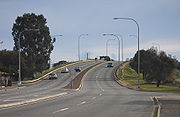
In the 1980s the extension and widening of Grand Junction Road and the construction of the Redhill Bridge spelt the end for many of the small shops in the area and property value experienced a slump. Since the start of the 21st century, with the new developments of Port Adelaide, the area is experiencing somewhat of a revival as is evidenced by the rising property value.
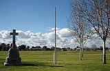
 Prior to European settlement the Rosewater area was mainly swampy marshlands of stagnant water. Today the area is almost entirely urbanised with only a small swamp area left next to the Redhill Bridge. The Eric Sutton Oval is one of two reserves in the area, with the other, Duffield Playground, a short distance away.
Using the selected averages from the 2001 Census, the average Rosewater resident is 38 years old, with a median weekly individual income of $200–$299. The median family income is $600–$699 per week with an average household size of 2.2 people.
As a whole, the Rosewater area has an average religious affiliation (67.8%) with Christians accounting for 59.2% of the total population. The top ten religious affiliations (in descending order) were: Catholic
, Anglican, Uniting Church, Buddhism
, Orthodox
, Pentecostal, Lutheran, Baptist
and Islam
.
Adelaide
Adelaide is the capital city of South Australia and the fifth-largest city in Australia. Adelaide has an estimated population of more than 1.2 million...
and is located 10 km north-west of Adelaide's central business district
City of Adelaide
The City of Adelaide is a local government area in the metropolitan area of Adelaide, South Australia. It covers the original Adelaide city centre settlement, , North Adelaide, and the Adelaide Park Lands which surround North Adelaide and the city centre.Established in 1840, the organisation now...
(CBD). Although mainly residential, there are many shops along Grand Junction Road
Grand Junction Road, Adelaide
Grand Junction Road is the longest east-west thoroughfare in the Adelaide metropolitan area, and is located approximately 9 kilometres north of the city centre. Travelling from the Port Adelaide region, it is mostly a double lane sealed road running 21 kilometres to the base of the Adelaide Hills...
and the retired "Rosewater Loop" railway line runs through the suburb. Rosewater is split in half by Grand Junction Road and bordered on the east by Addison and on the south by Torrens Road.
Originally, the area was mainly used as vegetable and dairy farmland but became more and more residential as the railway lines and Grand Junction Road were completed and as Port Adelaide grew and developed. Rosewater was also the site of the AdelaideRadio (VIA) maritime radio station
Coast radio station
A coast radio station is an on-shore maritime radio station which monitors radio distress frequencies and relays ship-to-ship and ship-to-land communications.-See also:* Marconi Station* Utility station...
system from 1912 to 1963.
History
Prior to European settlement, the area was inhabited by the Kaurna people. They called the general area Yatala from which the nearby Yatala takes its name. Further north, the area was known as Yertabulti and Yerta Boldingga, which means 'land of sleep or death' according to John Phillip Gell.The original subdivision of Rosewater was created in 1855 by Philip Levi
Philip Levi (pastoralist)
Philip Levi was an early settler and pastoralist of South Australia.Born at Brixton Hill, Surrey, England, at the age of sixteen, Levi arrived in South Australia, aboard the Eden in 1838 with his father, Nathaniel Philip Levi...
, when he subdivided Section 1189. The area just south of this, between Grand Junction and Torrens Roads, had been laid out by Osmond Gilles
Osmond Gilles
Osmond Gilles was a settler, pastoralist, mine owner and South Australia’s first colonial treasurer.After several years of working in Hamburg, Germany as a merchant, Gilles migrated to the new Australian colony on the HMS Buffalo in 1836 and acted as the Colonial Treasurer...
in 1847 and was known as "Yatala" (Sections 422 and 2072). The area west of Levi's subdivision was farmland owned by William Henry Gray and was called Graytown (Section 699). After Gray's death, Graytown was subdivided and sold as residential lands in 1898. Many of the streets there are named after Gray and his family; Rosetta, Edith, Alice and Jane (now Jennifer Street) were all family members.
The generally accepted explanation of the name "Rosewater" is attributed to Philip Levi who, it is claimed, said "The locality was a swamp, and the perfumes arising from the stagnant water were so offensive that I thought the name of Rosewater would, to some extent, act as a corrective". An alternative etymology came to light in 1945 when a Commissioner of Police
Police
The police is a personification of the state designated to put in practice the enforced law, protect property and reduce civil disorder in civilian matters. Their powers include the legitimized use of force...
report accompanying a parcel of human bone fragments discovered in Rosewater stated the following:
"Mrs J. Ward, the owner of the property, where the bones were found, states that her father arrived here 100 years ago and took up land and used water from a wall on the site in question, for the manufacture of sand bricks. The water in the well was so pure that it was named "rose water" and her father often remarked to her that the district derived its name therefrom".
As the population grew the area became crowded with subdivisions. The areas north and east of Levi's original "Rosewater" were called Rosewater North and Rosewater East respectively, while to the east of Evans Street were Dockville and Kingsnorth. East of these were the subdivisions of Brookesville, Ottoway and Ottoway East, which are now all part of Ottoway
Ottoway, South Australia
Ottoway is an industrial suburb of Adelaide, located in the City of Port Adelaide Enfield local government area. It is around west northwest of the city centre....
. East of Addison Road were Rosewater Gardens, Rosewater Gardens South and Stone's Farm (where the Flinders Hotel now stands). South of the "Yatala" area were Klemscott, Everton and Pennington
Pennington, South Australia
Pennington is an outer urban suburb of Adelaide, South Australia. It is located in the City of Charles Sturt.The suburb is residential, apart from a light industrial pocket to the south.-History:...
.
Rosewater Post Office opened around July 1877 and closed in 1982. Rosewater East Post Office on Grand Junction Road opened on 1 December 1947.
It was not until 1945 that the confusion was put to an end when the Port Adelaide Council moved to reduce the number of local district areas, combining 13 into what is now known as Rosewater.
Between the 1880s and the 1980s, Rosewater grew to become a reasonably large township with two hotels, a police and firestation, churches and many shops along Grand Junction Road. The Rosewater Gasworks was the largest local industry and many of the residents of the area worked in the timber mills, rail yards and woolsheds to the east of Port Adelaide.
Coast radio station
A coast radio station is an on-shore maritime radio station which monitors radio distress frequencies and relays ship-to-ship and ship-to-land communications.-See also:* Marconi Station* Utility station...
system, the sixth built in Australia and one of 19 around the country. Opened 1 October 1912 it operated from 8am to midnight every day of the week, and was one of the first points of contact for ships sailing south from Hong Kong and Japan. Apart from its major function of listening for ships' messages, Adelaide also handled traffic to and from the State telegraph system, and broadcast time signals to shipping. By 1963 the rapid industrialisation of the Rosewater area had increased electrical interference to the point where a move to a new site became necessary and the operation was moved to McLaren Vale where it operated until 1993 when it was shut down.
In the 1980s the extension and widening of Grand Junction Road and the construction of the Redhill Bridge spelt the end for many of the small shops in the area and property value experienced a slump. Since the start of the 21st century, with the new developments of Port Adelaide, the area is experiencing somewhat of a revival as is evidenced by the rising property value.
Geography
Residents
According to the 2001 Census the population of Rosewater is 3,274 and this is split almost evenly between male and female with only 8 more women than men. Of the local population 66% were born in Australia and 90% are Australian citizens, while the indigenous population makes up 2.7% of the total.Using the selected averages from the 2001 Census, the average Rosewater resident is 38 years old, with a median weekly individual income of $200–$299. The median family income is $600–$699 per week with an average household size of 2.2 people.
As a whole, the Rosewater area has an average religious affiliation (67.8%) with Christians accounting for 59.2% of the total population. The top ten religious affiliations (in descending order) were: Catholic
Catholic
The word catholic comes from the Greek phrase , meaning "on the whole," "according to the whole" or "in general", and is a combination of the Greek words meaning "about" and meaning "whole"...
, Anglican, Uniting Church, Buddhism
Buddhism
Buddhism is a religion and philosophy encompassing a variety of traditions, beliefs and practices, largely based on teachings attributed to Siddhartha Gautama, commonly known as the Buddha . The Buddha lived and taught in the northeastern Indian subcontinent some time between the 6th and 4th...
, Orthodox
Orthodox Christianity
The term Orthodox Christianity may refer to:* the Eastern Orthodox Church and its various geographical subdivisions...
, Pentecostal, Lutheran, Baptist
Baptist
Baptists comprise a group of Christian denominations and churches that subscribe to a doctrine that baptism should be performed only for professing believers , and that it must be done by immersion...
and Islam
Islam
Islam . The most common are and . : Arabic pronunciation varies regionally. The first vowel ranges from ~~. The second vowel ranges from ~~~...
.
|
| ||||||||||||||||||||||||||||||||||||
Politics
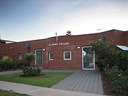
Rosewater is split between two state electoral districts - north of Grand Junction Road is considered part of the Port Adelaide district, while south is considered part of the Cheltenham electorate. In federal politics, the suburb is part of the electorate of Port Adelaide, which is represented by Mark Butler MP. The results shown here are from the Rosewater polling booth which is located at Mount Carmel College.Places of interest
- Rosewater Bowling Club
- Rosewater Football Club
- Rosewater Social Sports Club
- Eric Sutton Oval
- Duffield Playground
- Mount Carmel CollegeMount Carmel CollegeMount Carmel College is a Catholic secondary school located in Rosewater, South Australia. Established in 1927 by the Marist Brothers, it was an all boys school until December 1966...
- Rosewater Hotel
- Rosewater Uniting ChurchRosewater Uniting ChurchThe Rosewater Uniting Church was founded in Queenstown, South Australia as a Primitive Methodist Church in 1878. The Foundation Stone was laid by the Chairman of the Rosewater District Council, Mr. H.C.E...
- Wikimap marking the places mentioned in this article