

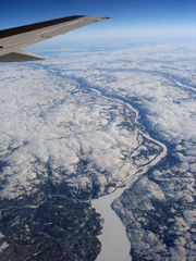
Rivière aux Mélèzes
Encyclopedia
Nunavik
Nunavik comprises the northern third of the province of Quebec, Canada. Covering a land area of 443,684.71 km² north of the 55th parallel, it is the homeland of the Inuit of Quebec...
, Quebec
Quebec
Quebec or is a province in east-central Canada. It is the only Canadian province with a predominantly French-speaking population and the only one whose sole official language is French at the provincial level....
, Canada
Canada
Canada is a North American country consisting of ten provinces and three territories. Located in the northern part of the continent, it extends from the Atlantic Ocean in the east to the Pacific Ocean in the west, and northward into the Arctic Ocean...
. It forms the western part of the large basin of the Koksoak River
Koksoak River
The Koksoak River is a river in northern Quebec, Canada, the largest river in the Nunavik region. The Inuit village and region's administrative center Kuujjuaq lies on the shores of the Koksoak, about south from its mouth.The name Koksoak is believed to originate from Moravian missionaries who...
. The other main tributary of the Koksoak is the Caniapiscau River
Caniapiscau River
The Caniapiscau River is a tributary of the Koksoak River in Nunavik, Quebec, Canada. In Cree the name of the river means rocky point.Starting from Lac Sevestre on the Canadian Shield, the Caniapiscau River flows northward through a wide, timbered glacial valley until it makes a sharp turn at its...
, to the south.
The English
English language
English is a West Germanic language that arose in the Anglo-Saxon kingdoms of England and spread into what was to become south-east Scotland under the influence of the Anglian medieval kingdom of Northumbria...
name "Larch River" probably comes from the larch
Larch
Larches are conifers in the genus Larix, in the family Pinaceae. Growing from 15 to 50m tall, they are native to much of the cooler temperate northern hemisphere, on lowlands in the north and high on mountains further south...
trees found in the sheltered valley of the river, which is, in less sheltered locations, as much as 400 kilometres beyond the northern limit of tree growth. Most of the basin is covered by sparse tundra
Tundra
In physical geography, tundra is a biome where the tree growth is hindered by low temperatures and short growing seasons. The term tundra comes through Russian тундра from the Kildin Sami word tūndâr "uplands," "treeless mountain tract." There are three types of tundra: Arctic tundra, alpine...
and is remains uninhabited, even by Inuit
Inuit
The Inuit are a group of culturally similar indigenous peoples inhabiting the Arctic regions of Canada , Denmark , Russia and the United States . Inuit means “the people” in the Inuktitut language...
. Owing to the intense glaciation, the basin is generally flat and does not rise to elevations beyond three hundred metres above sea level
Sea level
Mean sea level is a measure of the average height of the ocean's surface ; used as a standard in reckoning land elevation...
even after major post-glacial rebound
Post-glacial rebound
Post-glacial rebound is the rise of land masses that were depressed by the huge weight of ice sheets during the last glacial period, through a process known as isostasy...
. The climate
Climate
Climate encompasses the statistics of temperature, humidity, atmospheric pressure, wind, rainfall, atmospheric particle count and other meteorological elemental measurements in a given region over long periods...
is polar (Köppen ET) with temperatures ranging from about -20 C in January to 8 °C (46.4 °F) in July.
The river probably flowed into Hudson Bay
Hudson Bay
Hudson Bay , sometimes called Hudson's Bay, is a large body of saltwater in northeastern Canada. It drains a very large area, about , that includes parts of Ontario, Quebec, Saskatchewan, Alberta, most of Manitoba, southeastern Nunavut, as well as parts of North Dakota, South Dakota, Minnesota,...
before the Pleistocene
Pleistocene
The Pleistocene is the epoch from 2,588,000 to 11,700 years BP that spans the world's recent period of repeated glaciations. The name pleistocene is derived from the Greek and ....
. However, the fact that for ninety percent of the Quaternary
Quaternary
The Quaternary Period is the most recent of the three periods of the Cenozoic Era in the geologic time scale of the ICS. It follows the Neogene Period, spanning 2.588 ± 0.005 million years ago to the present...
Nunavik has been covered with glacial ice
Glacier
A glacier is a large persistent body of ice that forms where the accumulation of snow exceeds its ablation over many years, often centuries. At least 0.1 km² in area and 50 m thick, but often much larger, a glacier slowly deforms and flows due to stresses induced by its weight...
up to four kilometres thick has meant that, during the very brief deglaciations, ice dam
Ice dam
An ice dam occurs when water builds up behind a blockage of ice. Ice dams can occur in various ways.-Caused by a glacier:Sometimes a glacier flows down a valley to a confluence where the other branch carries an unfrozen river...
s and/or moraine
Moraine
A moraine is any glacially formed accumulation of unconsolidated glacial debris which can occur in currently glaciated and formerly glaciated regions, such as those areas acted upon by a past glacial maximum. This debris may have been plucked off a valley floor as a glacier advanced or it may have...
s have tended to prevent the river from flowing westwards. Hence, during the brief periods of deglaciation (generally only the latter half of interglacials), the river has flowed into the Koksoak River
Koksoak River
The Koksoak River is a river in northern Quebec, Canada, the largest river in the Nunavik region. The Inuit village and region's administrative center Kuujjuaq lies on the shores of the Koksoak, about south from its mouth.The name Koksoak is believed to originate from Moravian missionaries who...
.