
Rimutaka Rail Trail
Encyclopedia
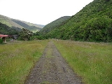
The Rimutaka Rail Trail is a walking and cycling track in the North Island
of New Zealand
. It runs between Maymorn
and Cross Creek
, and follows 22 kilometres (13.7 mi) of the original route of the Wairarapa Line
over the Rimutaka Ranges between the Mangaroa Valley and the Wairarapa
, including the world-famous Rimutaka Incline. Parts of the trail are also used by vehicles both from the regional council and from forestry companies with tree plantations in the area; members of the public have limited vehicular access from the Kaitoke
end to a car park, go-kart track and gun range. Access is also granted by permission to horse riders. Touring coaches have been used upon occasion to convey tourists and other visitors to various parts of the route.
The trail is a popular regional recreation facility and is used by more than 30,000 walkers, runners, and cyclists annually. It is part of a network of walking and cycling trails in public parks and reserves in the area. Several forestry roads diverge from the rail trail and are also used for recreational purposes.
The Incline section became the responsibility of the New Zealand Forest Service. All railway-related structures were removed from Cross Creek and Summit in the years following closure of the line. The Cross Creek yard and incline section were gradually reclaimed by nature. The Siberia embankment collapsed during a severe storm in 1967 after its drainage became blocked. A similar problem caused the Summit tunnel to flood.
The publication of A Line Of Railway in 1976 and establishment of Featherston’s
Fell Engine Museum helped spur interest in the Incline, prompting the Forest Service to provide permanent access to Cross Creek in 1984. In order to facilitate recreational use of the formation it drained Summit Tunnel and cleared the Cross Creek yard and incline formation. A proposal mooted in the mid 1980s for a walkway between Cross Creek and Kaitoke culminated in the opening of the Rimutaka Rail Trail on 1 November 1987, a joint project between the Wellington Regional Council and the Department of Conservation. Shelter sheds were constructed at Cross Creek and Summit, and several picnic areas along the route. A retaining wall and culverts were installed near the entrance to Price's Tunnel in 2009 by the Department of Conservation to remedy a slip that occurred the previous year.
If traversing the entire length of the rail trail, a trip can be timed to start at Cross Creek and meet a Wairarapa Connection train at Maymorn station.
The following car parks are available for users of the trail:
Points of interest along this section include:
and car park, is an access road which joins with the rail trail on the hillside above the Rimutaka Tunnel
portal. From the Kaitoke end, access to the rail trail can be gained either from one of several forestry roads which join up with the Kaitoke – Cross Creek section of the trail, or from a forestry road that connects with Kaitoke Loop Road about km west of Station Drive.
The following parking facilities are near the Maymorn end of this section of the trail:
There are no car parking facilities at the Kaitoke end.
Points of interest along this section of the route include:
North Island
The North Island is one of the two main islands of New Zealand, separated from the much less populous South Island by Cook Strait. The island is in area, making it the world's 14th-largest island...
of New Zealand
New Zealand
New Zealand is an island country in the south-western Pacific Ocean comprising two main landmasses and numerous smaller islands. The country is situated some east of Australia across the Tasman Sea, and roughly south of the Pacific island nations of New Caledonia, Fiji, and Tonga...
. It runs between Maymorn
Maymorn
Maymorn is a rural area of Upper Hutt city in the Wellington region of New Zealand. For statistical purposes, Maymorn is counted as part of Te Marua in the New Zealand census. The usual resident 2006 population of this area was 1,068...
and Cross Creek
Cross Creek
As a place in the United States, Cross Creek may refer to: *Cross Creek , a waterway connecting Orange Lake and Lochloosa Lake in southeastern Alachua County**Cross Creek, Florida, a community centered on the Cross Creek waterway...
, and follows 22 kilometres (13.7 mi) of the original route of the Wairarapa Line
Wairarapa Line
The Wairarapa Line is a secondary railway line in the south-east of the North Island of New Zealand, connecting the capital city of Wellington with the Wairarapa region. The line ends at Woodville, where it joins the Palmerston North - Gisborne Line...
over the Rimutaka Ranges between the Mangaroa Valley and the Wairarapa
Wairarapa
Wairarapa is a geographical region of New Zealand. It occupies the south-eastern corner of the North Island, east of metropolitan Wellington and south-west of the Hawke's Bay region. It is lightly populated, having several rural service towns, with Masterton being the largest...
, including the world-famous Rimutaka Incline. Parts of the trail are also used by vehicles both from the regional council and from forestry companies with tree plantations in the area; members of the public have limited vehicular access from the Kaitoke
Kaitoke
Kaitoke, part of Upper Hutt City, is a locality in the southern North Island of New Zealand. It is located at the northern end of the Hutt Valley, 45 kilometres northeast of Wellington City and six kilometres from the northern end of the Upper Hutt urban area...
end to a car park, go-kart track and gun range. Access is also granted by permission to horse riders. Touring coaches have been used upon occasion to convey tourists and other visitors to various parts of the route.
The trail is a popular regional recreation facility and is used by more than 30,000 walkers, runners, and cyclists annually. It is part of a network of walking and cycling trails in public parks and reserves in the area. Several forestry roads diverge from the rail trail and are also used for recreational purposes.
History
The Wellington City and Suburban Water Supply Board assumed ownership of the railway corridor land on the Wellington side of the Rimutaka Ranges following closure of the railway line in 1955. They retained the railway bridges so as to maintain vehicular access to the area for forestry purposes. Trees were planted by forestry staff around the summit yard and along the route from the late 1950s to the early 1970s. Access was restricted, and it was rare for anyone to be granted permission to enter the area for recreation.The Incline section became the responsibility of the New Zealand Forest Service. All railway-related structures were removed from Cross Creek and Summit in the years following closure of the line. The Cross Creek yard and incline section were gradually reclaimed by nature. The Siberia embankment collapsed during a severe storm in 1967 after its drainage became blocked. A similar problem caused the Summit tunnel to flood.
The publication of A Line Of Railway in 1976 and establishment of Featherston’s
Featherston, New Zealand
Featherston is a town in the north of the Wellington Region region of New Zealand. It lies in the Wairarapa, just north of the Rimutaka Tunnel, in the South Wairarapa District. The population was 2,340 in the 2006 Census....
Fell Engine Museum helped spur interest in the Incline, prompting the Forest Service to provide permanent access to Cross Creek in 1984. In order to facilitate recreational use of the formation it drained Summit Tunnel and cleared the Cross Creek yard and incline formation. A proposal mooted in the mid 1980s for a walkway between Cross Creek and Kaitoke culminated in the opening of the Rimutaka Rail Trail on 1 November 1987, a joint project between the Wellington Regional Council and the Department of Conservation. Shelter sheds were constructed at Cross Creek and Summit, and several picnic areas along the route. A retaining wall and culverts were installed near the entrance to Price's Tunnel in 2009 by the Department of Conservation to remedy a slip that occurred the previous year.
Management of the trail
The Cross Creek to Summit section is managed by the Department of Conservation, Summit to Maymorn by the Greater Wellington Regional Council. After Kaitoke the trail runs through Tunnel Gully Reserve.If traversing the entire length of the rail trail, a trip can be timed to start at Cross Creek and meet a Wairarapa Connection train at Maymorn station.
Cross Creek – Kaitoke
This 18 kilometres (11.2 mi) section can be accessed from either end. At Kaitoke there are signposted directions along Incline Rd off SH 2 to the start of the formation, km along which is a car park. On the Wairarapa side there is a turn-off to the Cross Creek car park from Western Lake Road, about 10 kilometres (6.2 mi) south-west of Featherston. From the Cross Creek car park it is a hour walk to the Cross Creek station yard. About six hours should be allowed to traverse the entire distance between Cross Creek and Kaitoke.The following car parks are available for users of the trail:
- Cross Creek: 41°10′5.59"S 175°14′11.92"E
- Kaitoke: 41°5′7.42"S 175°11′4.20"E
Points of interest along this section include:
- Cross Creek yard, the site of Cross Creek Railway StationCross Creek Railway StationCross Creek railway station was the base of operations for the Rimutaka Incline, a Fell railway over the Rimutaka Ranges, and part of the original Wairarapa Line between Upper Hutt and Featherston in the Wellington region of New Zealand’s North Island....
- Price’s Tunnel, 98 metres (321.5 ft) long on an S-curve
- Horseshoe Gully, the site of the Siberia embankment
- Siberia Tunnel, 108 metres (354.3 ft) long
- Summit Tunnel, 584 metres (1,916 ft) long
- Summit yard, the site of Summit Railway StationSummit Railway StationSummit railway station was at the summit of the Wairarapa Line over the Rimutaka Ranges in the Wellington region of New Zealand’s North Island and was where trains were marshalled for a descent down the Incline or for Fell locomotives to be extricated from a train that had ascended the Incline...
- Ladle Bend Creek bridge, 70 metres (229.7 ft) long, restored by the regional council in 2002
- Pakuratahi bridge, 28 metres (91.9 ft) long, rebuilt in 1910 and restored by the regional council in 2001
- Rimutaka Tunnel ventilation shaft, built after it was decided to dieselise the line instead of electrifying it as originally planned, and it was found that there was insufficient natural ventilation to operate diesel locomotives through the tunnel
- Pakuratahi Tunnel, 73 metres (239.5 ft) long
- Munitions Bend bridge, the footbridge here was installed in 2003
Kaitoke – Maymorn
Though this 4.25 kilometres (2.6 mi) section can be walked or cycled from either end, access is easiest from the Maymorn end of the trail. At the end of Plateau Road is a car park for recreational users of the Tunnel Gully reserve, from which access can be gained to the rail trail. At the intersection of Maymorn Road and Parkes Line Road, near Maymorn Railway StationMaymorn Railway Station
Maymorn railway station is a twin platform, rural railway station serving the small settlement of Maymorn on the Maymorn Plateau, east of Upper Hutt, in New Zealand’s North Island...
and car park, is an access road which joins with the rail trail on the hillside above the Rimutaka Tunnel
Rimutaka Tunnel
The Rimutaka Tunnel is a railway tunnel through New Zealand's Rimutaka Ranges, between Maymorn, near Upper Hutt, and Featherston, on the Wairarapa Line.The tunnel, which was opened to traffic on 3 November 1955, is long...
portal. From the Kaitoke end, access to the rail trail can be gained either from one of several forestry roads which join up with the Kaitoke – Cross Creek section of the trail, or from a forestry road that connects with Kaitoke Loop Road about km west of Station Drive.
The following parking facilities are near the Maymorn end of this section of the trail:
- Plateau Road: 41°6′14.74"S 175°9′13.43"E
- Maymorn Railway Station
There are no car parking facilities at the Kaitoke end.
Points of interest along this section of the route include:
- Mangaroa Tunnel, 152 metres long
Future
The Rimutaka Incline Railway Heritage Trust plans to reinstate the railway line over the Rimutaka Ranges, and expects to incorporate all of the former railway formation that currently comprises the rail trail. The laying of track on this formation is still many years away. The trust is currently working on stage one of their plan, which involves the development of facilities at Maymorn. Later stages include the development of alternative facilities for current users of the rail trail prior to the laying of track.See also
- Cross Creek Railway StationCross Creek Railway StationCross Creek railway station was the base of operations for the Rimutaka Incline, a Fell railway over the Rimutaka Ranges, and part of the original Wairarapa Line between Upper Hutt and Featherston in the Wellington region of New Zealand’s North Island....
- Kaitoke Railway StationKaitoke Railway StationKaitoke railway station was a single-platform rural railway station on the Wairarapa Line between Upper Hutt and Featherston in the Wellington region of New Zealand’s North Island. Initially it was the railhead of the Wairarapa Line, at a point where the railway met the main road between Upper...
- List of rail trails
- Maymorn Railway StationMaymorn Railway StationMaymorn railway station is a twin platform, rural railway station serving the small settlement of Maymorn on the Maymorn Plateau, east of Upper Hutt, in New Zealand’s North Island...
- Rimutaka Incline
- Rimutaka TunnelRimutaka TunnelThe Rimutaka Tunnel is a railway tunnel through New Zealand's Rimutaka Ranges, between Maymorn, near Upper Hutt, and Featherston, on the Wairarapa Line.The tunnel, which was opened to traffic on 3 November 1955, is long...
- Summit Railway StationSummit Railway StationSummit railway station was at the summit of the Wairarapa Line over the Rimutaka Ranges in the Wellington region of New Zealand’s North Island and was where trains were marshalled for a descent down the Incline or for Fell locomotives to be extricated from a train that had ascended the Incline...
External links
- Rimutaka Rail Trail. Greater Wellington Regional Council.
- Tunnel Gully. Greater Wellington Regional Council.
- Rimutaka Rail Trail. Department of Conservation.