

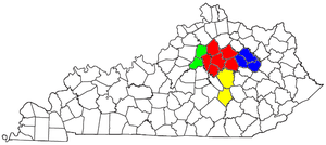
Richmond-Berea micropolitan area
Encyclopedia
United States Census Bureau
The United States Census Bureau is the government agency that is responsible for the United States Census. It also gathers other national demographic and economic data...
, is an area consisting of two counties in Kentucky
Kentucky
The Commonwealth of Kentucky is a state located in the East Central United States of America. As classified by the United States Census Bureau, Kentucky is a Southern state, more specifically in the East South Central region. Kentucky is one of four U.S. states constituted as a commonwealth...
, anchored by the cities of Richmond
Richmond, Kentucky
There were 10,795 households out of which 24.4% had children under the age of 18 living with them, 35.2% were married couples living together, 12.8% had a female householder with no husband present, and 48.6% were non-families. Of all households, 34.7% were made up of individuals and 8.8% had...
and Berea
Berea, Kentucky
-Demographics:As of the census of 2000, there were 9,851 people, 3,693 households, and 2,426 families residing in the city. The population density was 1,055.4 people per square mile . There were 4,115 housing units at an average density of 440.9 per square mile...
. As of the 2000 census
United States Census, 2000
The Twenty-second United States Census, known as Census 2000 and conducted by the Census Bureau, determined the resident population of the United States on April 1, 2000, to be 281,421,906, an increase of 13.2% over the 248,709,873 persons enumerated during the 1990 Census...
, the μSA had a population of 87,454 (though a July 1, 2009 estimate placed the population at 99,762).
The Richmond–Berea Micropolitan Statistical Area is part of the Lexington
Lexington, Kentucky
Lexington is the second-largest city in Kentucky and the 63rd largest in the US. Known as the "Thoroughbred City" and the "Horse Capital of the World", it is located in the heart of Kentucky's Bluegrass region...
–Fayette
Fayette County, Kentucky
Fayette County is a county located in the U.S. state of Kentucky. The population was 295,083 in the 2010 Census. Its territory, population and government are coextensive with the city of Lexington, which also serves as county seat....
–Frankfort
Frankfort, Kentucky
Frankfort is a city in Kentucky that serves as the state capital and the county seat of Franklin County. The population was 27,741 at the 2000 census; by population it is the 5th smallest state capital in the United States...
–Richmond Combined Statistical Area
Lexington-Fayette-Frankfort-Richmond, KY Combined Statistical Area
The Lexington-Fayette-Frankfort-Richmond, KY Combined Statistical Area, created by the United States Bureau of the Census in 2000, is the 76th largest Combined Statistical Area of the United States...
.
Incorporated places
- BereaBerea, Kentucky-Demographics:As of the census of 2000, there were 9,851 people, 3,693 households, and 2,426 families residing in the city. The population density was 1,055.4 people per square mile . There were 4,115 housing units at an average density of 440.9 per square mile...
(Principal city) - BrodheadBrodhead, KentuckyBrodhead is a city in Rockcastle County, Kentucky, United States. The population was 1,193 at the 2000 census. It is part of the Richmond–Berea Micropolitan Statistical Area.-Geography:Brodhead is located at ....
- LivingstonLivingston, KentuckyLivingston is a city in Rockcastle County, Kentucky, United States. The population was 228 at the 2000 census. It is part of the Richmond–Berea Micropolitan Statistical Area.-Geography:Livingston is located at ....
- Mount VernonMount Vernon, KentuckyMount Vernon is a city in Rockcastle County, Kentucky, United States. The population was 2,592 at the 2000 census. It is the county seat of Rockcastle County. It is located at the junction of U.S...
- RichmondRichmond, KentuckyThere were 10,795 households out of which 24.4% had children under the age of 18 living with them, 35.2% were married couples living together, 12.8% had a female householder with no husband present, and 48.6% were non-families. Of all households, 34.7% were made up of individuals and 8.8% had...
(Principal city)
Unincorporated places
- BighillBighill, KentuckyBighill is an unincorporated community in Madison County, Kentucky, United States. It lies east of Berea on Kentucky Route 21. The community is part of the Richmond–Berea Micropolitan Statistical Area....
- BoonesboroughBoonesborough, KentuckyBoonesborough is an unincorporated community in Madison County, Kentucky, United States. It lies in the central part of the state along the Kentucky River. Boonesborough is part of the Richmond–Berea Micropolitan Statistical Area....
- BybeeBybee, KentuckyBybee is an unincorporated community in Madison County, Kentucky, United States. It lies east of Richmond on Kentucky Route 52. The community is part of the Richmond–Berea Micropolitan Statistical Area. by Jason Fritz, a collection of poems from that will be released on October 16, 2009,...
- KirksvilleKirksville, KentuckyKirksville is an unincorporated community in Madison County, Kentucky, United States. It lies southwest of Richmond on County Road 1295. The community is part of the Richmond–Berea Micropolitan Statistical Area....
- WacoWaco, KentuckyWaco is an unincorporated community in Madison County, Kentucky, United States. It lies east of Richmond on Kentucky Route 52. The community is part of the Richmond–Berea Micropolitan Statistical Area....
- Valley ViewValley View, KentuckyValley View is an unincorporated community in Madison County, Kentucky, United States. It lies west of Richmond on Kentucky Route 169. The community is part of the Richmond–Berea Micropolitan Statistical Area.-See also:*Valley View Ferry...
Demographics
As of the censusCensus
A census is the procedure of systematically acquiring and recording information about the members of a given population. It is a regularly occurring and official count of a particular population. The term is used mostly in connection with national population and housing censuses; other common...
of 2000, there were 87,454 people, 33,696 households, and 22,982 families residing within the μSA. The racial makeup of the μSA was 94.41% White, 3.65% African American, 0.27% Native American, 0.61% Asian, 0.02% Pacific Islander, 0.28% from other races
Race (United States Census)
Race and ethnicity in the United States Census, as defined by the Federal Office of Management and Budget and the United States Census Bureau, are self-identification data items in which residents choose the race or races with which they most closely identify, and indicate whether or not they are...
, and 1.08% from two or more races. Hispanic or Latino of any race were 0.90% of the population.
The median income for a household in the μSA was $28,168, and the median income for a family was $35,831. Males had a median income of $29,372 versus $20,438 for females. The per capita income
Per capita income
Per capita income or income per person is a measure of mean income within an economic aggregate, such as a country or city. It is calculated by taking a measure of all sources of income in the aggregate and dividing it by the total population...
for the μSA was $14,564.