
René-Levasseur Island
Encyclopedia
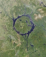
René-Levasseur Island is a large island
in the center of Lake Manicouagan in Quebec
, Canada
. Its highest peak is Mount Babel
, at 952 m (3,123 feet). With a total area of 2,020 km² (and a diameter of 72 km), the island is larger in terms of area than the lake in which it is situated. René-Levasseur Island is considered to be the second largest island in the world located in a lake, in terms of area (the largest is Manitoulin Island
in Lake Huron
) .
The geological structure was formed by the impact of a meteorite 214 million years ago. The meteorite is believed to have been about 5 km in diameter, and would have hit the earth at a speed of 17 km/s, the fourth most powerful known impact the earth has seen. The impact of the meteorite formed a crater roughly 100 km in diameter, the centre of which forms the island known today. It became an artificial island
when the Manicouagan reservoir was flooded, merging two crescent-shaped lakes: Mouchalagane Lake on the western side and Manicouagan Lake on the eastern side.
The island was named after René Levasseur, the chief engineer responsible for the construction of Hydro-Québec
's Daniel-Johnson Dam
on the Manicouagan River
, which created the Manicouagan Reservoir
. The structure is the world's largest multiple-arch dam
. Levasseur died at the age of 35, only days before the dam's inauguration.
There is an Innu
anecdote concerning René Levasseur's and Daniel Johnson's deaths. Both died of cardiovascular problems. The Innu say that just as they were clogging the rivers, the Earth's veins and arteries, the creator responded by clogging theirs in turn.
The Manicouagan Reservoir, and René-Levasseur Island are sometimes called the "eye of Quebec".
The Island is currently the subject of an ongoing legal battle, as the Innu
First Nation of Betsiamites
is taking legal action to protect its indigenous land from logging. The Quebec Court of Appeal
recently made a ruling allowing Kruger Inc. to resume its logging activities (April 28, 2006).
The Island is also the object of an environmental/ecological campaign lobbying the government of Québec to create a protected area spanning the entire Island. The group, SOS Levasseur arose in 2003 partly from the interest that mainstream environmental groups in Québec demonstrated during environmental consultations. All groups recommended that René-Levasseur Island be protected in whole. The Island has been proposed as a Canadian National Park, an ecological reserve, a biodiversity reserve and an exceptional geological site. There seems to be an exceptional concentration of old-growth boreal forest stands on the island.
SOS Levasseur has been conducting research expeditions to the Island since January 2005, whose aim is to identify old-growth forest stands and to obtain their protection under the Quebec Forest Law as Exceptional Forest Ecosystems (EFE).
The Ministry of Natural Resources and Fauna (MRNFQ), along with Kruger Inc. have already Identified 7 EFEs spanning approximately 25 km². SOS Levasseur has submitted an additional 7 surveyed in the summer of 2005, and is expected to submit many more from the 2006 and 2007 expeditions.
The MRNFQ has yet to recognize the 7 sites proposed by SOS Levasseur.
Island
An island or isle is any piece of sub-continental land that is surrounded by water. Very small islands such as emergent land features on atolls can be called islets, cays or keys. An island in a river or lake may be called an eyot , or holm...
in the center of Lake Manicouagan in Quebec
Quebec
Quebec or is a province in east-central Canada. It is the only Canadian province with a predominantly French-speaking population and the only one whose sole official language is French at the provincial level....
, Canada
Canada
Canada is a North American country consisting of ten provinces and three territories. Located in the northern part of the continent, it extends from the Atlantic Ocean in the east to the Pacific Ocean in the west, and northward into the Arctic Ocean...
. Its highest peak is Mount Babel
Mount Babel (Quebec)
Mount Babel is the highest peak of the René-Levasseur Island, at above sea-level, which is above the Manicouagan Reservoir level. It lies within the Louis-Babel Ecological Reserve in Quebec, Canada.-History:...
, at 952 m (3,123 feet). With a total area of 2,020 km² (and a diameter of 72 km), the island is larger in terms of area than the lake in which it is situated. René-Levasseur Island is considered to be the second largest island in the world located in a lake, in terms of area (the largest is Manitoulin Island
Manitoulin Island
Manitoulin Island is a Canadian island in Lake Huron, in the province of Ontario. It is the largest island in a freshwater lake in the world. In addition to the historic Anishinaabe and European settlement of the island, archeological discoveries at Sheguiandah have demonstrated Paleo-Indian and...
in Lake Huron
Lake Huron
Lake Huron is one of the five Great Lakes of North America. Hydrologically, it comprises the larger portion of Lake Michigan-Huron. It is bounded on the east by the Canadian province of Ontario and on the west by the state of Michigan in the United States...
) .
The geological structure was formed by the impact of a meteorite 214 million years ago. The meteorite is believed to have been about 5 km in diameter, and would have hit the earth at a speed of 17 km/s, the fourth most powerful known impact the earth has seen. The impact of the meteorite formed a crater roughly 100 km in diameter, the centre of which forms the island known today. It became an artificial island
Artificial island
An artificial island or man-made island is an island or archipelago that has been constructed by people rather than formed by natural means...
when the Manicouagan reservoir was flooded, merging two crescent-shaped lakes: Mouchalagane Lake on the western side and Manicouagan Lake on the eastern side.
The island was named after René Levasseur, the chief engineer responsible for the construction of Hydro-Québec
Hydro-Québec
Hydro-Québec is a government-owned public utility established in 1944 by the Government of Quebec. Based in Montreal, the company is in charge of the generation, transmission and distribution of electricity across Quebec....
's Daniel-Johnson Dam
Daniel-Johnson Dam
The Daniel-Johnson Dam , formerly known as Manic-5, is a multiple arch buttress dam on the Manicouagan River which creates Manicouagan Reservoir. The dam is composed of 14 buttresses and 13 arches and is north of Baie-Comeau in Quebec, Canada...
on the Manicouagan River
Manicouagan River
The Manicouagan River is a river in Côte-Nord region of Quebec, Canada. The river originates at the Daniel-Johnson Dam of the Manicouagan Reservoir and flows approximately south, emptying into the Saint Lawrence River near Baie-Comeau...
, which created the Manicouagan Reservoir
Manicouagan Reservoir
Manicouagan Reservoir is an annular lake in central Quebec, Canada. The lake covers an area of 1,942 km², and its eastern shore is accessible via Route 389. The island in the centre of the lake is known as René-Levasseur Island, and its highest point is Mount Babel...
. The structure is the world's largest multiple-arch dam
Arch dam
An arch dam is a type of dam that is curved and commonly built with concrete. The arch dam is a structure that is designed to curve upstream so that the force of the water against it, known as hydrostatic pressure, presses against the arch, compressing and strengthening the structure as it pushes...
. Levasseur died at the age of 35, only days before the dam's inauguration.
There is an Innu
Innu
The Innu are the indigenous inhabitants of an area they refer to as Nitassinan , which comprises most of the northeastern portions of the provinces of Quebec and some western portions of Labrador...
anecdote concerning René Levasseur's and Daniel Johnson's deaths. Both died of cardiovascular problems. The Innu say that just as they were clogging the rivers, the Earth's veins and arteries, the creator responded by clogging theirs in turn.
The Manicouagan Reservoir, and René-Levasseur Island are sometimes called the "eye of Quebec".
The Island is currently the subject of an ongoing legal battle, as the Innu
Innu
The Innu are the indigenous inhabitants of an area they refer to as Nitassinan , which comprises most of the northeastern portions of the provinces of Quebec and some western portions of Labrador...
First Nation of Betsiamites
Betsiamites, Quebec
Betsiamites, also known as Pessamit , is a First Nations reserve and Innu community in the Canadian province of Quebec, located about southwest from Baie-Comeau along the north shore of the Saint Lawrence River at the mouth of the Betsiamites River...
is taking legal action to protect its indigenous land from logging. The Quebec Court of Appeal
Quebec Court of Appeal
The Court of Appeal for Quebec is the highest judicial court in Quebec, Canada....
recently made a ruling allowing Kruger Inc. to resume its logging activities (April 28, 2006).
The Island is also the object of an environmental/ecological campaign lobbying the government of Québec to create a protected area spanning the entire Island. The group, SOS Levasseur arose in 2003 partly from the interest that mainstream environmental groups in Québec demonstrated during environmental consultations. All groups recommended that René-Levasseur Island be protected in whole. The Island has been proposed as a Canadian National Park, an ecological reserve, a biodiversity reserve and an exceptional geological site. There seems to be an exceptional concentration of old-growth boreal forest stands on the island.
SOS Levasseur has been conducting research expeditions to the Island since January 2005, whose aim is to identify old-growth forest stands and to obtain their protection under the Quebec Forest Law as Exceptional Forest Ecosystems (EFE).
The Ministry of Natural Resources and Fauna (MRNFQ), along with Kruger Inc. have already Identified 7 EFEs spanning approximately 25 km². SOS Levasseur has submitted an additional 7 surveyed in the summer of 2005, and is expected to submit many more from the 2006 and 2007 expeditions.
The MRNFQ has yet to recognize the 7 sites proposed by SOS Levasseur.