
Red Rock Coulee
Encyclopedia
Red Rock Coulee is located in south-eastern Alberta
, Canada
. It is 60 kilometers south of the city of Medicine Hat on Highway 887, just outside the hamlet of Seven Persons. The main feature of this natural landscape
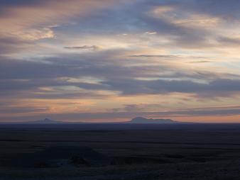
is the huge red boulders; some measuring 2.5 meters across. They are scattered over a relatively small distance and can be viewed without walking far at all. From the viewpoint off Highway 887 you can view the red rocks and see the Sweetgrass Hills of Montana
on the horizon.
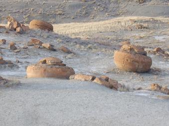
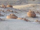
The most striking features of this landscape are the round reddish boulders. These are sandstone concretions and at up to 2.5 metres in diameter, they are among the largest in the world. The boulders were formed in prehistoric seas as layers of sand, calcite and iron oxide collected around a nucleus formed by shells, leaves or bones. The concretions grew larger as the circulating waters deposited more layers. The reddish colour comes from iron oxide. Look carefully at the concretions - you may be able to see their "growth rings" (layers of sediment deposition) and fossilized shells, leaves or bones.
Alberta
Alberta is a province of Canada. It had an estimated population of 3.7 million in 2010 making it the most populous of Canada's three prairie provinces...
, Canada
Canada
Canada is a North American country consisting of ten provinces and three territories. Located in the northern part of the continent, it extends from the Atlantic Ocean in the east to the Pacific Ocean in the west, and northward into the Arctic Ocean...
. It is 60 kilometers south of the city of Medicine Hat on Highway 887, just outside the hamlet of Seven Persons. The main feature of this natural landscape
Natural landscape
A natural landscape is a landscape that is unaffected by human activity. A natural landscape is intact when all living and nonliving elements are free to move and change. The nonliving elements distinguish a natural landscape from a wilderness. A wilderness includes areas within which natural...
is the huge red boulders; some measuring 2.5 meters across. They are scattered over a relatively small distance and can be viewed without walking far at all. From the viewpoint off Highway 887 you can view the red rocks and see the Sweetgrass Hills of Montana
Montana
Montana is a state in the Western United States. The western third of Montana contains numerous mountain ranges. Smaller, "island ranges" are found in the central third of the state, for a total of 77 named ranges of the Rocky Mountains. This geographical fact is reflected in the state's name,...
on the horizon.
Geographical Features
Many features make Red Rock Coulee a special site to visit. Bedrock is close to the surface in this area, covered by only a thin layer of soil. Water erosion has carved the landscape over time and a badlands topography has formed in places. The bands of colour visible in the exposed bedrock are made of dark gray shales, greenish and gray sandstones, bentonitic clays and thin bands of ironstone.The most striking features of this landscape are the round reddish boulders. These are sandstone concretions and at up to 2.5 metres in diameter, they are among the largest in the world. The boulders were formed in prehistoric seas as layers of sand, calcite and iron oxide collected around a nucleus formed by shells, leaves or bones. The concretions grew larger as the circulating waters deposited more layers. The reddish colour comes from iron oxide. Look carefully at the concretions - you may be able to see their "growth rings" (layers of sediment deposition) and fossilized shells, leaves or bones.
See also
- List of coulees in Alberta
- List of lakes in Alberta
- Geography of AlbertaGeography of AlbertaAlberta is a Canadian province. Located in Western Canada, the province has an area of and is bounded to the south by the U.S. state of Montana along 49° north for ; to the east at 110° west by the province of Saskatchewan for ; and at 60° north the Northwest Territories for...
- CouleeCouleeCoulee is applied rather loosely to different landforms, all of which refer to a kind of valley or drainage zone.The word coulee comes from the Canadian French coulée, from French word couler meaning "to flow"....