

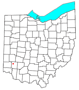
Red Lion, Ohio
Encyclopedia
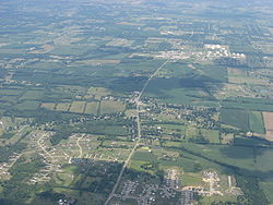
Unincorporated area
In law, an unincorporated area is a region of land that is not a part of any municipality.To "incorporate" in this context means to form a municipal corporation, a city, town, or village with its own government. An unincorporated community is usually not subject to or taxed by a municipal government...
in southwestern Clearcreek Township
Clearcreek Township, Warren County, Ohio
Clearcreek Township is one of the eleven townships of Warren County, Ohio, United States, located in the north central portion of the county. It had a population of 20,974 in 2000, up from 13,344 in 1990; of this total, 8,747 lived in the unincorporated portions of the township. It was originally...
, Warren County
Warren County, Ohio
Warren County is a county located in the state of Ohio, United States. The population was 212,693 at the 2010 census. Its county seat is Lebanon. Warren County was erected May 1, 1803, from Hamilton County, and named for Dr...
, Ohio
Ohio
Ohio is a Midwestern state in the United States. The 34th largest state by area in the U.S.,it is the 7th‑most populous with over 11.5 million residents, containing several major American cities and seven metropolitan areas with populations of 500,000 or more.The state's capital is Columbus...
, United States
United States
The United States of America is a federal constitutional republic comprising fifty states and a federal district...
, at the intersection of State Routes 741
Ohio State Route 741
State Route 741 is a north–south state highway in the southwest portion of the U.S. state of Ohio. The southern terminus of the route is at a diamond interchange with I-71 at its Exit 25 near Kings Mills, adjacent to the Kings Island Amusement Park...
, 122
Ohio State Route 122
In Ohio, State Route 122 is a state highway which runs from the Ohio-Indiana state line in Preble County east of Eaton, Ohio to State Route 48 near Lebanon, Ohio a distance of . The Route once ran past State Route 48 to US Route 42. This section was renamed "Old State Route 122", but this is no...
, and 123
Ohio State Route 123
In Ohio, State Route 123 is a state highway which runs Ohio Route 251 about southeast of Blanchester to Germantown, a distance of .-External links:*...
. Red Lion is approximately five miles south of Springboro
Springboro, Ohio
Springboro is an affluent suburb of Cincinnati and Dayton located in Warren and Montgomery counties in the U.S. state of Ohio. It is in Warren County's Clearcreek and Franklin Townships and Montgomery County's Miami Township...
and five miles northwest of Lebanon, Ohio
Lebanon, Ohio
The population at the 2010 census was 20,033. As of the census of 2000, there were 16,962 people residing in the city. The population density was 1,440.6 people per square mile . There were 6,218 housing units at an average density of 528.1 per square mile...
.
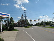
Two landmarks in Red Lion are a historic Methodist
Methodism
Methodism is a movement of Protestant Christianity represented by a number of denominations and organizations, claiming a total of approximately seventy million adherents worldwide. The movement traces its roots to John Wesley's evangelistic revival movement within Anglicanism. His younger brother...
church building and the Red Lion Cemetery. Red Lion was named after an inn that was once a stage coach stop, but this building no longer exists.