

Rattlesnake Island (New Hampshire)
Encyclopedia
Lake Winnipesaukee
Lake Winnipesaukee is the largest lake in the U.S. state of New Hampshire. It is approximately long and from wide , covering — when Paugus Bay is included—with a maximum depth of ....
, New Hampshire
New Hampshire
New Hampshire is a state in the New England region of the northeastern United States of America. The state was named after the southern English county of Hampshire. It is bordered by Massachusetts to the south, Vermont to the west, Maine and the Atlantic Ocean to the east, and the Canadian...
. There are conflicting accounts of where it got its name, because its shape looks somewhat like a snake, but some say it is named for a rattlesnake population that lived there.
The island is located within the town of Alton
Alton, New Hampshire
Alton is a town in Belknap County, New Hampshire, United States. The population was 5,250 at the 2010 census. It is home to Alton Bay State Forest and Mount Major State Forest. Alton includes the village of Alton Bay, a long-time resort located beside Lake Winnipesaukee.The primary settlement in...
.
Topography and physical features
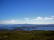
Rattlesnake Island is about 2 miles (3 km) long, and approximately 5 miles (8 km) around its shore. The topography varies greatly. Some sections of the island are quite steep, with the land rising dramatically from the shore (and affording spectacular views), while other sections, particularly on the "peninsula", which protrudes from the southerly side of the island, rise gradually. Rattlesnake Island is the highest (in elevation) island on Lake Winnipesaukee. The top of so-called "Mount Rattlesnake" (the top of Rattlesnake Island is not officially named) is 874 feet (266.4 m) high - rising 370 feet (112.8 m) above the mean lake level.Due to its great height, the island affords wonderful views of the lake. There are hiking trails interconnecting all parts of the island, and these are used frequently by island residents.
Rattlesnake Island Association
Island property owners are required to join the Rattlesnake Island Association, including payment of modest yearly association dues. In addition to owning land on the island itself, the Rattlesnake Island Association owns a mainland area to the east of Smith Point in Glidden Cove which includes short-term docking, a boat launching ramp, and two large parking areas for residents and guests. There is also an area for the parking of boat trailers.Electric power and wired telephone service is available to all parts of the island. However, as of 2011 no other land-based services such as cable TV are available.