
Rammey Marsh Lock
Encyclopedia
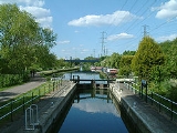
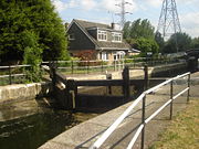
Rammey Marsh Lock is a lock
on the River Lee Navigation
at Enfield
. The area adjacent to the lock is known as Rammey Marsh and close to the River Lee Flood Relief Channel
.
map of 1887, named from Ramhey 1538, Rammey 1610, probably 'island (of dry ground in marsh) where rams are pastured', from Old English ramm and ēg.
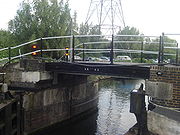
 The lock and the adjoining cut are of 1864. Across the lock tail, a reused cast- iron footbridge dated 1835.
. Which can be accessed at Lea Road.
Pedestrian and cycle access via the towpath
which forms part of the Lea Valley Walk.
or Waltham Cross
Lock (water transport)
A lock is a device for raising and lowering boats between stretches of water of different levels on river and canal waterways. The distinguishing feature of a lock is a fixed chamber in which the water level can be varied; whereas in a caisson lock, a boat lift, or on a canal inclined plane, it is...
on the River Lee Navigation
River Lee Navigation
The Lee Navigation is a canalised river incorporating the River Lea . Its course runs from Hertford Castle Weir all the way to the River Thames at Bow Creek. The first lock of the navigation is Hertford Lock the last being Bow Locks....
at Enfield
London Borough of Enfield
The London Borough of Enfield is the most northerly London borough and forms part of Outer London. It borders the London Boroughs of Barnet, Haringey and Waltham Forest...
. The area adjacent to the lock is known as Rammey Marsh and close to the River Lee Flood Relief Channel
River Lee Flood Relief Channel
The River Lee Flood Relief Channel is located in the Lea Valley and flows between Ware, Hertfordshire and Stratford, east London. Work started on the channel in 1947 following major flooding and was fully operational by 1976...
.
Etymology
Rammey Marsh is marked thus on the Ordnance SurveyOrdnance Survey
Ordnance Survey , an executive agency and non-ministerial government department of the Government of the United Kingdom, is the national mapping agency for Great Britain, producing maps of Great Britain , and one of the world's largest producers of maps.The name reflects its creation together with...
map of 1887, named from Ramhey 1538, Rammey 1610, probably 'island (of dry ground in marsh) where rams are pastured', from Old English ramm and ēg.
History
Public access
Vehicular access only from the north via Lea Valley WalkLea Valley Walk
The Lea Valley Walk is a long-distance path located between Leagrave, the source of the River Lea near Luton, and the Thames, at Limehouse Basin, Limehouse, east London. From its source much of the walk is rural. At Hertford the path follows the towpath of the River Lee Navigation, and it becomes...
. Which can be accessed at Lea Road.
Pedestrian and cycle access via the towpath
Towpath
A towpath is a road or trail on the bank of a river, canal, or other inland waterway. The purpose of a towpath is to allow a land vehicle, beasts of burden, or a team of human pullers to tow a boat, often a barge...
which forms part of the Lea Valley Walk.
Public transport
Nearest station Enfield LockEnfield Lock railway station
Enfield Lock railway station is in the London Borough of Enfield in north east London, and is in Travelcard Zone 6, on the Tottenham Hale branch of the Lea Valley Lines, on the West Anglian Railway...
or Waltham Cross
Waltham Cross railway station
Waltham Cross railway station, opened in 1840, is a railway station that serves Waltham Cross in Hertfordshire, England. It is also the closest railway station to Waltham Abbey, Essex, England...